Cycle Route

Moderators: John, Sharon, Fossil, Lucky Poet, crusty_bint, Jazza, dazza

Postby Captain Brittles » Fri May 06, 2005 3:19 pm

Dexter St. Clair wrote:
The Home Brew shop as they can't afford to go out, The Broomhill Shopping Cente to deal their drugs which gave them the money to buy their flat, Roastit Bubbly Jocks for a not too expensive but good meal out, The Rosevale Tavern to meet up with fellow season ticket holders and of course LIDL for their shopping.


Why would these prospective riverside apartment dwellers buy a home brew kit with the proceedings of their alleged drug dealing activities and then dine out and finish an evening off in a pub ? A contradiction or two there Dex.
User avatar
Captain Brittles
Third Stripe
Third Stripe
 
Posts: 531
Joined: Fri Feb 25, 2005 1:05 am
Location: The Gleneagles front

Postby adouglasmathie » Tue May 10, 2005 4:16 pm

The current cyclepath from town out to Scotstoun is a joke. Ideally it should all be along the banks of the Clyde.

However, the worst bit is the pedestrian bridge over the expressway which is just not bike friendly.

So some of this sounds like a good idea.

Presumably, new flats only get planning permission if they open up public/bike access to the water front. Can anyone in GCC planning confirm this is right.
adouglasmathie
Just settling in
Just settling in
 
Posts: 6
Joined: Wed Apr 06, 2005 1:44 pm
Location: Glasgow

Cycle path part removed

Postby Dexter St. Clair » Sun May 29, 2005 4:47 pm

The domolition of the cycle path has started. South Street, west of Harmsworth Street has already been flattenned along with the Harmesworth bar.
User avatar
Dexter St. Clair
Third Stripe
Third Stripe
 
Posts: 6252
Joined: Tue Nov 16, 2004 9:54 pm

Postby Strike Team » Sun May 29, 2005 10:32 pm

Some bumff came though the letterbox the other day describing the road works for the harbour. It shows a "proposed light rapid transit route" running immediately South of, and parallel to, Castlebank St., then apparrently running along an extended Castlebank St., and the disappearing past Yorkhill Quay. Whether this is the end of of the line, it goes into a tunnel, or this is simply the result of some cooncil bureaucrat drawing random railway tracks on the map in felt-tip pen after a particularly heavy bevvy session is not clear.

What is clear though is the sheer fluorescent idiocly of the cooncil in allowing railway land to be taken over for the Glasgow Harbour project, while blathering on about developing a rapid transit/guided bus system. Common sense would of course dictate using the existing embankment, Partick Central site, etc. for light rail. But common sense and Glasgow City Council are like matter and anti-matter - incapable of existing in the same universe.
User avatar
Strike Team
Second Stripe
Second Stripe
 
Posts: 128
Joined: Thu May 06, 2004 7:43 pm
Location: Leafy Suburbia

Postby Pgcc93 » Wed Jun 08, 2005 6:35 pm

Wholesale demolition of the former railway bridges now in full swing on the cycletrack on South Street.

Image


Image


Image


Image


Old Station about to disappear

Image
User avatar
Pgcc93
Third Stripe
Third Stripe
 
Posts: 4104
Joined: Thu Jul 24, 2003 8:12 pm
Location: Hotel Du Vin

Postby Pgcc93 » Wed Jun 08, 2005 6:39 pm

some more images from South Street

Harmsworth Street bridge ......gone!

Image

Going!

Image

Going!!

Image


Gone!!!
Image
User avatar
Pgcc93
Third Stripe
Third Stripe
 
Posts: 4104
Joined: Thu Jul 24, 2003 8:12 pm
Location: Hotel Du Vin

Postby Fossil » Wed Jun 08, 2005 6:42 pm

I hope you got the sign PGCC :!: :?

Fossil
Bum tit tit bum tit tit play yer hairy banjo
User avatar
Fossil
-
-
 
Posts: 12310
Joined: Sun Feb 08, 2004 12:07 am
Location: Pitt Street

Postby Pgcc93 » Wed Jun 08, 2005 6:44 pm

Cutting up the remains

Image

Image


Image


Image
User avatar
Pgcc93
Third Stripe
Third Stripe
 
Posts: 4104
Joined: Thu Jul 24, 2003 8:12 pm
Location: Hotel Du Vin

Postby Pgcc93 » Wed Jun 08, 2005 6:46 pm

Modern Fossil wrote:I hope you got the sign PGCC :!: :?

Fossil


I asked the demolition guy for it and he happily obliged but it was too well fecked to bother about. So I just took a pic instead.
User avatar
Pgcc93
Third Stripe
Third Stripe
 
Posts: 4104
Joined: Thu Jul 24, 2003 8:12 pm
Location: Hotel Du Vin

Postby Pgcc93 » Wed Jun 08, 2005 6:51 pm

Bridge at Thornwood about to go next.

Image


Image


Image


Image


Yet another little bit of Glasgow history bites the dust.
User avatar
Pgcc93
Third Stripe
Third Stripe
 
Posts: 4104
Joined: Thu Jul 24, 2003 8:12 pm
Location: Hotel Du Vin

Postby Vladimir » Wed Jun 08, 2005 7:02 pm

When did this line close down :?:
User avatar
Vladimir
Third Stripe
Third Stripe
 
Posts: 1830
Joined: Mon May 02, 2005 9:40 am
Location: Confédération Générale du Travail

Postby Alycidon » Wed Jun 08, 2005 7:27 pm

Passenger services ceased on the 5th of October 1964, along with the remainder of the former Caledonian services via Glasgow Central Low Level. Freight traffic remained, and Scotstoun signal box remained manned until 1st December 1968 after which the line was worked as a freight siding.
The former through route was severed to the East beyond Partick Central in 1965 and was worked as a siding from Rothesay Dock and Yoker yard serving various sidings, closures were as follows:
PARTICK EAST JN to Partick Central Goods 23-Oct-1978
SCOTSTOUN WEST to Balmoral Street Level Crossing 18-Nov-1966
Scotstoun West to Yoker Ferry, S S E B Siding 31-Jan-1978
Scotstoun, Balmoral Street Level Crossing to Meadowside Granary Siding 03-Mar-1969
Yoker Yard to Partick, Meadowside Granary Siding 22-Mar-1980
User avatar
Alycidon
Third Stripe
Third Stripe
 
Posts: 1047
Joined: Mon Apr 18, 2005 11:11 am
Location: Eaglesham

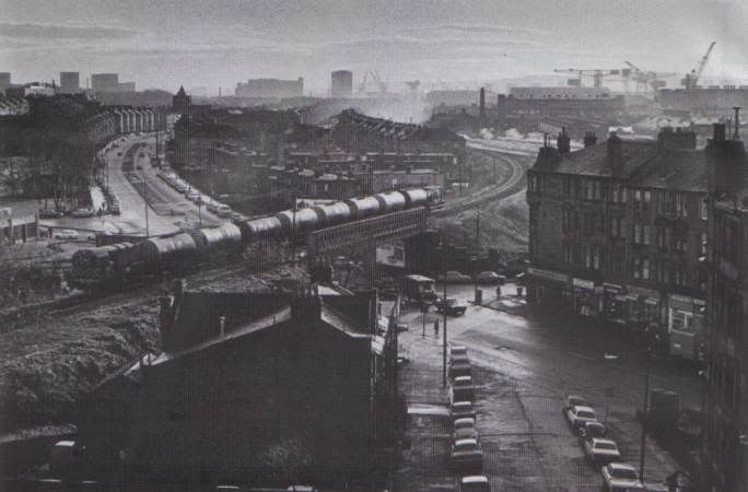
Postby Alycidon » Wed Jun 08, 2005 7:43 pm

Image
From George C O'Hara's book "Scottish Urban and Rural Branch Lines" April 1976
User avatar
Alycidon
Third Stripe
Third Stripe
 
Posts: 1047
Joined: Mon Apr 18, 2005 11:11 am
Location: Eaglesham

Postby Vladimir » Wed Jun 08, 2005 7:43 pm

Thanks for the info. Would it not be kind of useful if that line was still in operation, given the transoprt needs for that area :? , or does it miss out a lot on its route.
User avatar
Vladimir
Third Stripe
Third Stripe
 
Posts: 1830
Joined: Mon May 02, 2005 9:40 am
Location: Confédération Générale du Travail

Postby james73 » Wed Jun 08, 2005 10:56 pm

Alycidon wrote:Image
From George C O'Hara's book "Scottish Urban and Rural Branch Lines" April 1976


Great picture - is there a date on it? EDIT - just noticed, April 76?

Looks like the line is singled. Scotstoun West station (and the main line itself)
was behind the tenements to the right. The bridge is part of the cycle route
and I've cycled passed the neds that congregate on it many times. :roll:


James H
james73
Third Stripe
Third Stripe
 
Posts: 2035
Joined: Wed Dec 17, 2003 4:08 pm
Location: urbanglasgow.co.uk - come & join us.....

Next

Return to Glasgow Chat (Coffee Lounge)

Who is online

Users browsing this forum: No registered users and 11 guests