I'm not in a position where I can say that you're wrong and GCC are right (or vice-versa, as I'm still open to both possibilities). If I was asked to state who I think is most likely to be right I think I’d possibly side with you at the moment, however I don’t think the case for the opposite view has been defeated as yet. To show what I mean, I thought I'd make a few points to challenge your argument/logic.
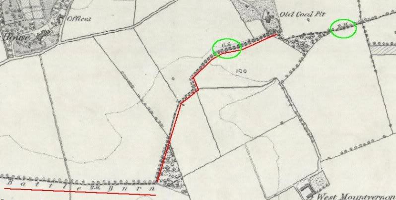
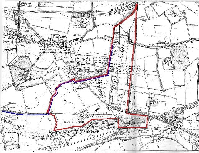
I've been doing a bit of digging and have noticed that not only does the GCC plan - of where they think the burn comes from - follow the old parish boundaries
I think historical errors have been compounded in that boundaries have been assumed to be the line of a water course
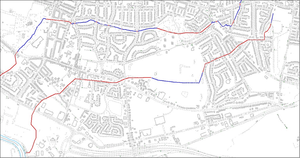
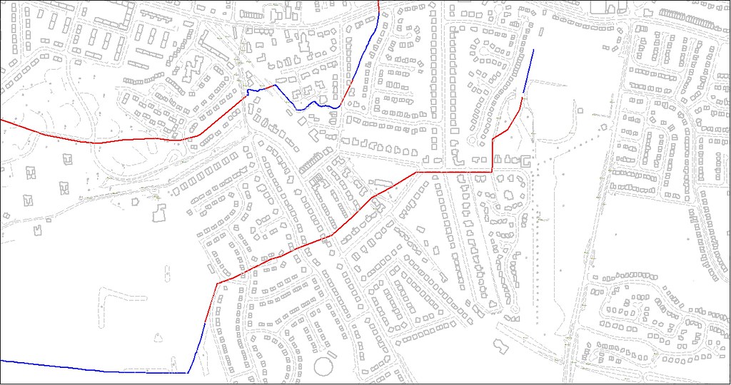
The original line of the burn followed the old parish boundary, however the GCC indicated culvert route doesn't. In fact, through the residential area of Mount Vernon the culvert route noticeably deviates from the boundary. I could demonstrate this more accurately if I was at work so I could access our GIS, however to give a rough indication of this I have added (by hand as a lime green line) the old parish boundary (as identified on the OS 1864 published plan) to one of the plans I posted previously.
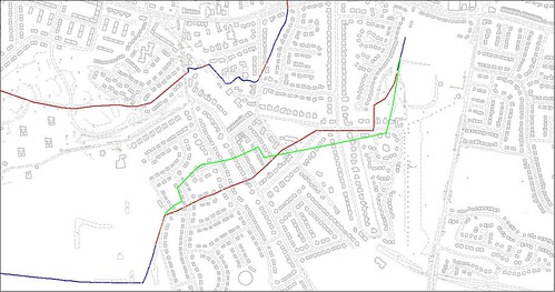
Larger version
hereYour theory re the identified burn line being the result of such historical errors would seem well founded if the GCC identified route still followed the old parish boundary. As it clearly doesn’t though, how do you account for the variation in the line?
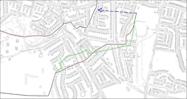
Let us assume for a moment that GCC are correct and also that the burn did originally follow the parish boundary all the way up to Barrachnie Park. It could be suggested that, through the older part of Mount Vernon (i.e. in the general vicinity of the bowling/tennis club), it appears as though the burn was culverted along a route that enabled the construction of houses on the land that it previously flowed through. Alterations such as this have been (and still are – a recent example being the diversion of the Tollcross Burn for the ongoing Barratt development next to Easterhouse train station) fairly common practice (with both natural and man-made drainage) over the last couple of centuries and this is a plausible explanation for the variation in the line of the burn.
Another issue to consider is that GCC (or any local authority for that matter) wouldn’t acknowledge the presence of a culverted watercourse unless they had very good reason to believe it existed. I know through personal experience that local authorities will steadfastly refuse to acknowledge that a previously uncharted ‘conduit’ is a culverted watercourse without strong evidence to prove as much. This is in part due to common law, which places responsibilities upon riparian owners of watercourses, whether they be open or culverted (e.g. GCC are responsible for maintaining the structural integrity of any culvert passing beneath land they own, such as highways or parks) and legislation that places flood prevention duties on local authorities (e.g. they have a duty to undertake any reasonable work that is necessary to prevent watercourse flooding of non-agricultural land).
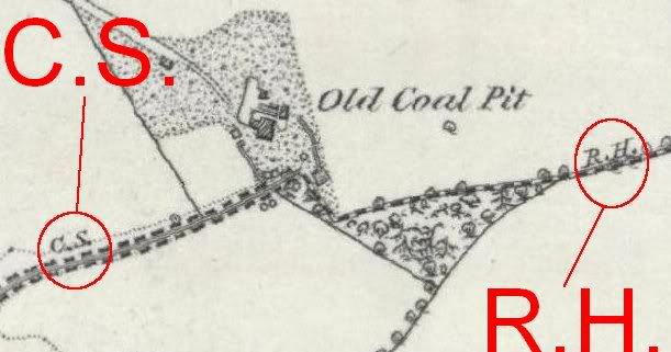
There is no reference to C.S. in the present day area west of the Barrachnie sports fields by the first surveyors…
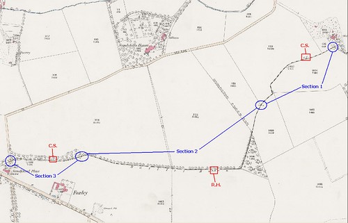
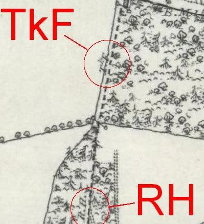
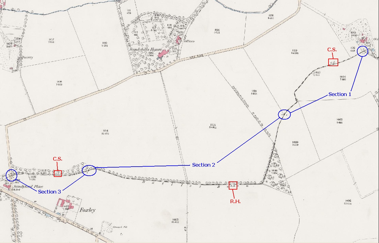
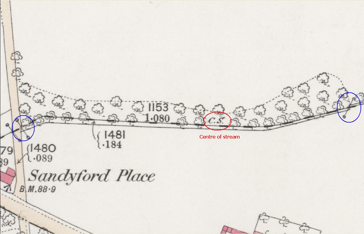
The absence of any clear reference to, or indication of, a burn in any given area is by no means conclusive evidence that a burn didn’t (or doesn’t) exist. Hedges (as I’m sure you are aware) were/are a very common field/property boundary marker feature, however it was also common for hedge lines to follow watercourses (and ditches, field drains, etc) - I’ve seen many instances on old plans where the boundary line features changed from being the centre of a stream to the root of a hedge and back again several times. You don’t even have to go far downstream on this very burn for an example of this, as is shown in the below images.
Larger version
hereSection 1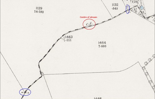
Larger version
hereSection 2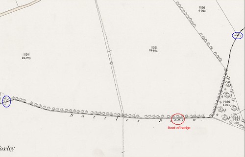
Larger version
hereSection 3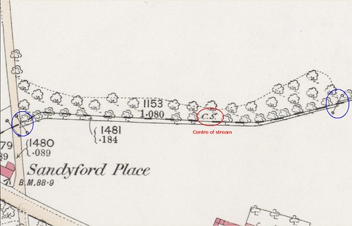
Larger version
hereThis type of scenario is replicated further downstream on the Battles Burn and on many other watercourses/old boundaries across the country.
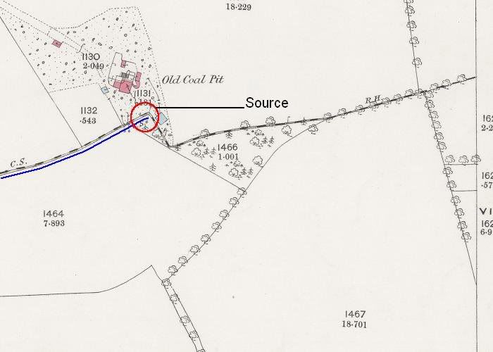
I believe the 1861 estate plan that you referred to shows that the line of the ‘water pan’ continued east past the pit (and the last boundary line marker related to the centre of the stream) and actually followed at least part of the ‘roof of hedge’ section of the parish boundary line.
I’d suggest the above possibly negates this element of your argument or at the very least provides substantial reason for doubt as to its validity.
…and it would be unimaginable for a land owner to culvert a burn that was draining his fields so there can't have been one there at all.
I can appreciate the general reasoning of why it would seem your view on this makes sense, however you’ve made a broadly sweeping statement as though it’s a matter of fact. Although such scenarios weren’t particularly common, I can assure you that it isn’t as unimaginable as you might think. I’ll give a couple of examples that I believe demonstrate this.
Not too long ago, I was involved in the investigation of a flooding problem in the Spittal area of Rutherglen, at a point right on the Glasgow/South Lanarkshire local authority boundary. I don’t want to post sensitive information (for reasons that I’m sure everyone can understand) so I won’t go into specific detail – basically, during heavy storm conditions, some properties were suffering severe and repeated flooding for unknown reason. The affected properties were on the South Lanarkshire side of the boundary but the floodwater was coming from the Glasgow side and flowing overland towards them. The local authorities made a joint request for the assistance of Scottish Water in determining the cause of the problem.
I spoke to some of the affected residents and this revealed that the floodwater was believed to be surcharging from a surface water conduit (I say conduit as its legal status is still being debated) at the bottom of Castlemilk Drive. Our records only showed the downstream line of this conduit up to the local authority boundary (they still do actually so this has just reminded me to get them updated!) so we didn’t know where it was discharging to. I therefore took a walk along the nearby Cityford Burn (in the expectation of finding a piped outlet to it) and this resulted in my identifying what appeared to be an uncharted culverted tributary of stone cundy type construction.
Cityford Burn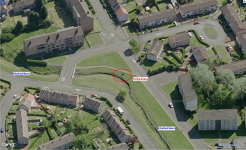
Larger version
hereInitial background checks/discussions revealed that all three parties were unaware of the existence of a tributary at this location. I therefore arranged a dye test of the conduit and this revealed that (i) there seemed to be an unusually large dry weather flow (DWF) through it (the preceding few days had been very warm and dry) and (ii) it was discharging to the Cityford Burn via the cundy (incidentally, the flow through its outfall seemed much clearer in appearance than is generally the case with surface water discharges arising from storm run-off from highways and roofs).
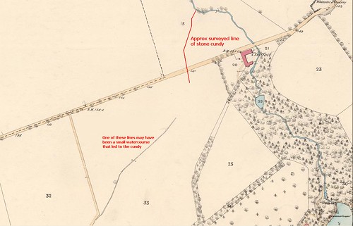
A review of old OS plans and archived development drainage drawings of the Castlemilk/Spittal area failed to reveal any indication of a tributary (culverted or otherwise) at this point so we decided to carry out a CCTV survey of the conduit and cundy. We didn’t get very far downstream from the conduit (I won’t say why but you can probably guess) but we did manage to make reasonable upstream progress from the cundy outfall (we had to construct a couple of access chambers on it to enable this though). The below images show the approx surveyed line of the cundy as far as the point we reached.
Looking north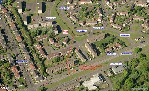
Larger version
hereLooking south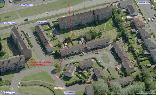
Larger version
hereIt’s evident that the uncharted nature of this cundy resulted in the construction of at least a few dwellings over the top of it – this simply wouldn’t have been allowed to happen if the authorities had known it existed. It’s not unheard of for structures to be built over, or close to, culverts or sewers, but this is only permitted where diversion of them would be at unreasonable cost and they are of sufficient depth – in many cases protective measures (e.g. concrete surround of the length being built over) also have to be implemented before construction is allowed. In this case, however, we have residential buildings over a stone-built cundy of significant age and unknown structural integrity – I’m glad I don’t live there!
As I mentioned above, none of the old plans we reviewed contained any indication of a watercourse on the line of this cundy or even anything to suggest that there was a confluence at its outfall point to the Cityford Burn. Most of the reviewed plans far pre-dated the development of this area so it seems certain that this cundy would have been constructed through rural land (probably of agricultural use).
The below image is an extract of an 1864 OS plan, on which I have roughly annotated the surveyed line of the cundy. As you can see, other than my annotation there is no indication of a watercourse on this line. At the time of our investigations, I speculated that one of the lines shown to the south-west may have been an upstream stretch of a small watercourse that passed through the cundy, however there’s no other evidence to substantiate this.
Larger version
hereMy second example is (you will be glad to hear) far shorter.
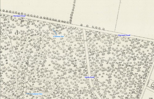
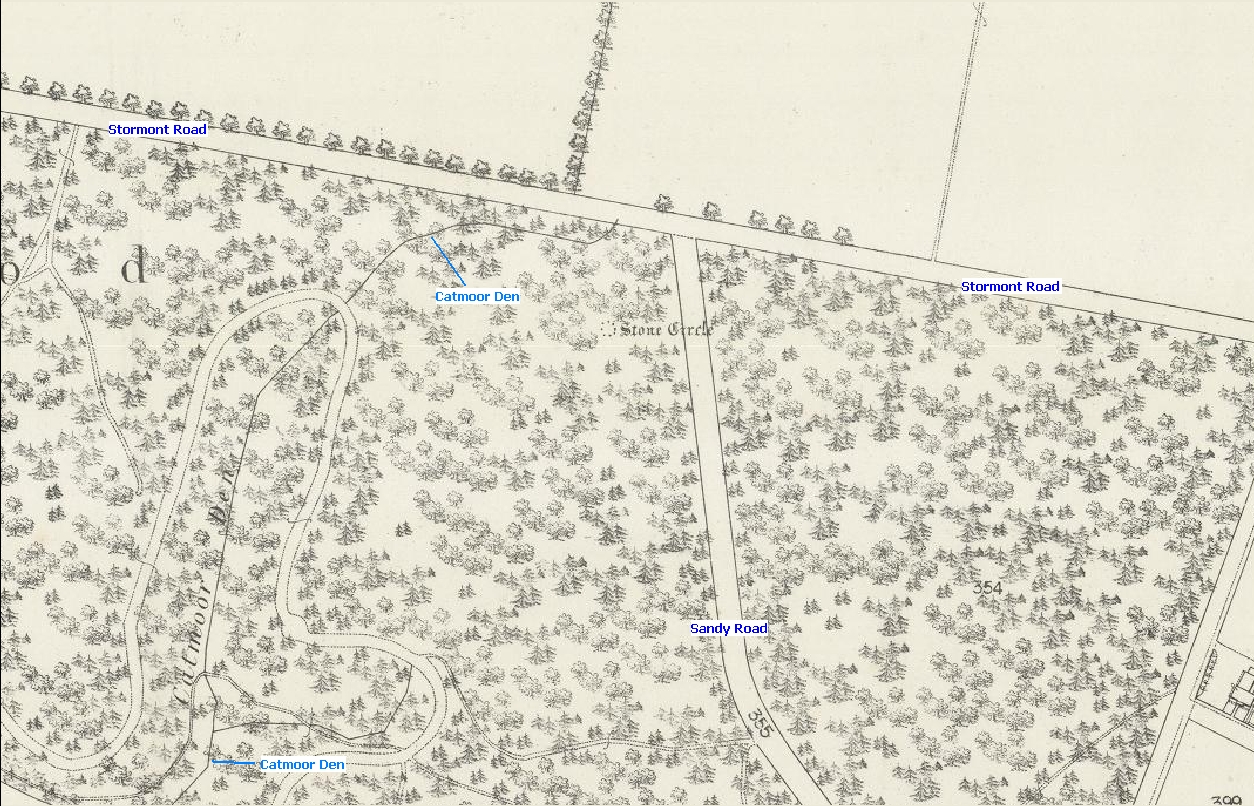
This involves another flooding investigation I was involved in not too long ago – this time a bit further afield in Scone, Perthshire. During the course of our investigations we looked into the background of a burn called the Catmoor Den – see the below images.
Larger version
here
Larger version
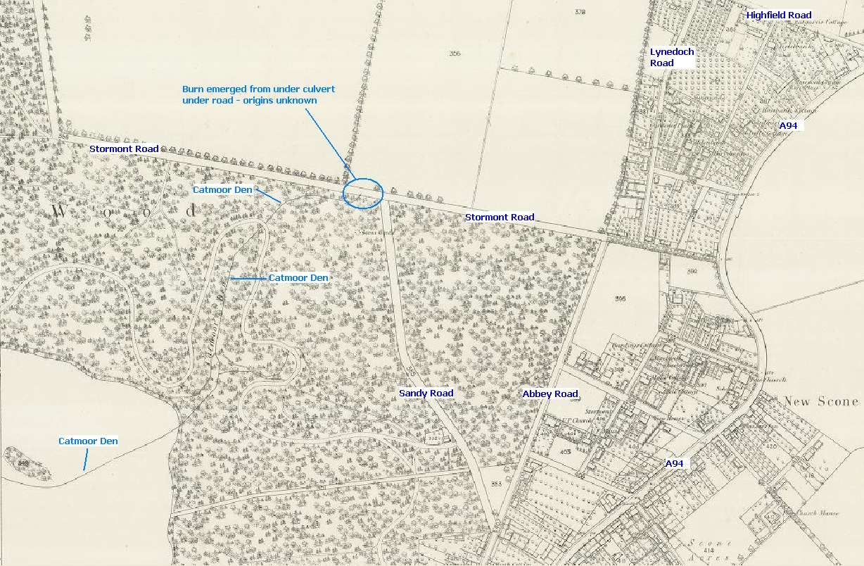
hereAnnotated aerial view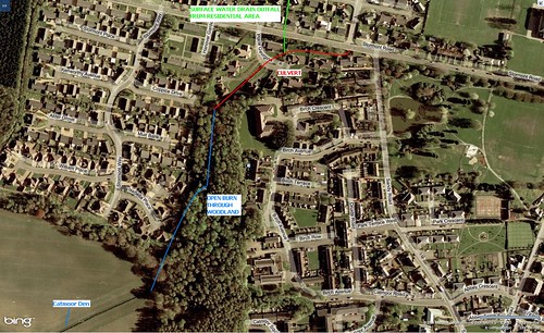
Larger version
hereThis burn is clearly indicated on both old and current OS plans (I don’t have a current one prepared unfortunately), is of a fair size and conveys a significant DWF (even in the area of its upper reaches where we were undertaking investigations).
Both old and current plans only show the line of the burn up to Stormont Road though. North of the road, there is absolutely no indication of its uppermost reaches (or origins) on any plan that I’ve seen to date. This wouldn’t be unusual if it was a very small watercourse but, as I’ve already said, it carries a large DWF. In short, I believe that the same scenario exists here as did in the first example – i.e. culverting of a watercourse through rural/agricultural land for unknown reasons.
The annotated aerial view shows the line of the existing open section of the burn and a part south of Stormont Road that was later culverted to enable a residential development. We discovered during the course of our investigations that very little flow comes from the point where the burn appeared from beneath the road. Practically all of the DWF now arrives via the outfall pipe of the surface water drainage that serves the residential area to the north of Stormont Road. It is worth pointing out that the main surface water drain within this residential area is inordinately large for the area it serves – experience suggests to me that it is more than likely the original culvert to the north of Stormont Road was diverted through the ‘new development’ drainage.
What I have tried to demonstrate through the above examples is that rural land owners did, on occasion at least, culvert watercourses that were draining their fields. I don’t know what the reasons for this might have been but I’d suggest one possibility may have been to simply remove a natural barrier. For instance, a farmer may have wished to culvert (or divert) a burn to enable him to combine several fields/areas to maximise cultivation possibilities – the presence of a burn would restrict the area of land you could farm but if you covered it over you could plough and plant right over the top of it.
There is, of course, one way that could be used to find out what GCC know about the Battles Burn – that great enemy of all publicly funded bodies, an FOI Act request. Not sure I want to find out what they know though – I’m kind of enjoying the thread!


