The Hidden Glasgow Forums
To post in the forums you will need to first register. All new members are welcomed, with one caveat: You must behave and be nice AND SEARCH BEFORE POSTING!
Past Present Vol 2
Moderators: John, Sharon, Fossil, Lucky Poet, crusty_bint, Jazza, dazza
Re: Past Present Vol 2
![]() by banjo » Tue Mar 10, 2009 12:03 pm
by banjo » Tue Mar 10, 2009 12:03 pm
- banjo
- Third Stripe

- Posts: 3516
- Joined: Wed Sep 24, 2008 7:26 pm
Re: Past Present Vol 2
![]() by Vinegar Tom » Wed Mar 11, 2009 12:29 am
by Vinegar Tom » Wed Mar 11, 2009 12:29 am
And I got the angle wrong
-

Vinegar Tom - Third Stripe
- Posts: 2403
- Joined: Sat Sep 15, 2007 11:59 pm
- Location: Trying to find the exit from Black Mesa
Re: Past Present Vol 2
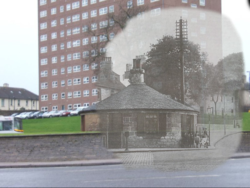
![]() by Glesga_Steve » Sat Mar 14, 2009 1:15 am
by Glesga_Steve » Sat Mar 14, 2009 1:15 am
yoker brian wrote:tobester wrote:Can i ask about the Girnin Gates in Garscadden...
Is part of it still visible from the railway line? I noticed yesterday an old building at the lineside between Scotstounhill and Garscadden, but not sure what it is as ive never seen it before, just caught a glimpse of it as the train sped thru on the way to Dalmuir.
I think I know which building your referring to Tobester, although if it's the one I'm thinking of, it would be on your left hand side as you travel between Yoker and Garscadden Station, just before the Hawick Street overbridge at the west end of Yoker Train Depot.
It's a small pump house I found the info here online, and I'm sure I have more info and possibly a photo somewhere on my old PC which I'll look out sometime soon
It may well have been connected with the Old Yoker Distillery which stood on the land now occupied by the Scottish Power Depot, it's not as far as I know linked to the Yoker Burn which is buried below the railway about 50/ 60 yards to the west of the building your mention in your post.
Cheers
Brian
Was browsing the net for stuff on the Yoker Burn (don't ask... work related!) when I came across this site and subject. Thought I'd sign up so I could comment further...
The building being referred to isn't a sewerage pumphouse (the Historic Scotland listed building report is accurate other than in regard to that point). It is sewerage related though - the building is called Yoker Castle and it is sited on the trunk sewer (Western Outfall Sewer - approx 2.1m diameter at this point if my memory serves me correct) between Partick Pumping Station (on the south side of Dumbarton Road, on the west bank of the River Kelvin - a hundred yards or so east of Partick Cross) and Dalmuir WwTW (sewage treatment works in Clydebank). It was built around 1902 and, like the sewer, is now owned by Scottish Water. I'm not doing it justice by saying this but the building is effectively a huge above-ground manhole chamber... you go into the building, up a flight of stairs (these are within the "turret" on the south-east corner of the building) and onto a sort of gantry that overlooks the channel of the sewer (which is open-topped within the building) - there is also access to an overflow arrangement that allows sewage flows to be spilled to the Yoker Burn culvert on the rare occasions when the sewer becomes surcharged during periods of prolonged intense rainfall. I've been in the building a couple of times over the years - it's quite impressive despite my rather unflattering "manhole chamber" description.
Anyone who has noticed the building might have also noticed there is an earth bund between the railway line and the houses to the north. The bund had to be built over the trunk sewer to protect it because the crown (top) of the sewer was above the surrounding ground levels at this point. The sewer is very flat in gradient along it's full length and while at some sections it is very deep underground (e.g. approx 14m at the junction of Crow Road and Clarence Drive), it is very shallow through Yoker and Clydebank.
I have some fantastic old drawings of the building and sewer layout at work - I'll try to scan them and post them up if anyone is interested.
Regards,
Steven
-

Glesga_Steve - Third Stripe
- Posts: 674
- Joined: Sat Mar 14, 2009 12:46 am
Re: Past Present Vol 2
![]() by Josef » Sat Mar 14, 2009 2:46 am
by Josef » Sat Mar 14, 2009 2:46 am
-

Josef - Third Stripe
- Posts: 8144
- Joined: Mon Jul 10, 2006 9:43 pm
Re: Past Present Vol 2
![]() by banjo » Sat Mar 14, 2009 11:39 am
by banjo » Sat Mar 14, 2009 11:39 am
- banjo
- Third Stripe
- Posts: 3516
- Joined: Wed Sep 24, 2008 7:26 pm
Re: Past Present Vol 2
![]() by BTJustice » Tue Mar 17, 2009 10:43 pm
by BTJustice » Tue Mar 17, 2009 10:43 pm
More to follow now my broken wrist is healing.
Dave
www.rewoundandfound.com
Check oot ma flickr page;
http://www.flickr.com/photos/route9autos/
For handmade jewellery, go to:
http://www.weegemjo.co.uk
-

BTJustice - Third Stripe
- Posts: 1605
- Joined: Sun Dec 10, 2006 5:57 pm
- Location: Cathcart
Re: Past Present Vol 2
![]() by Dexter St. Clair » Thu Mar 19, 2009 8:08 am
by Dexter St. Clair » Thu Mar 19, 2009 8:08 am
received the tip off from Glasgow Guide Allhails has them on his Flickr site. Certainly press photographs.
I don't know whetehr robertpool had found this site previously as his link to a cheapside photo leads to a private set. but apologies if this has been posted before
-
Dexter St. Clair - Third Stripe
- Posts: 6252
- Joined: Tue Nov 16, 2004 9:54 pm
Re: Past Present Vol 2
![]() by Synchro » Fri Mar 20, 2009 1:29 pm
by Synchro » Fri Mar 20, 2009 1:29 pm
tombro wrote:I went to St Sixtus' School (the main school on Kinfauns Drive and both of its annexes, one off Ledmore Drive Wher I started school, and the other on Airgold Drive opposite Camus Place Primary School) from early 1955 until leaving for Australia at the end of 1960.
I lived on Ledmore Drive, number 29, which I believe is boarded up now. I went to Langfaulds Primary School, which was the handiest school ever (as it was actually IN my square
-
Synchro - Just settling in

- Posts: 7
- Joined: Sat Aug 02, 2008 9:36 am
Re: Past Present Vol 2
![]() by Dave » Sun Mar 22, 2009 8:01 am
by Dave » Sun Mar 22, 2009 8:01 am
www.davehouston.co.uk
- Dave
- Third Stripe
- Posts: 2779
- Joined: Wed Feb 07, 2007 12:24 am
- Location: Uzbekistan
Re: Past Present Vol 2
![]() by tombro » Sun Mar 22, 2009 8:53 am
by tombro » Sun Mar 22, 2009 8:53 am
Can you tell me exactly where Langfaulds Primary School was ? I started in a St Sixtus annexe at the Linkwood Drive end of Ledmore Drive and also went to another annexe between Ledmore Drive and Airgold Drive roughly in the middle of both streets and opposite Camus Place School.
I vaguely remember the buildings opposite this small annexe being a school, too !
Can you enlighten me ?
Tombro
- tombro
- Second Stripe

- Posts: 265
- Joined: Sun Dec 30, 2007 9:36 am
- Location: Central Western NSW
Re: Past Present Vol 2
![]() by TheOutSider » Mon Mar 23, 2009 8:29 pm
by TheOutSider » Mon Mar 23, 2009 8:29 pm

Camphill House in Queen's Park, Shawlands as it was in around 1904.

- TheOutSider
- Busy bunny

- Posts: 10
- Joined: Wed Apr 09, 2008 9:15 am
Re: Past Present Vol 2
![]() by TheOutSider » Mon Mar 23, 2009 8:56 pm
by TheOutSider » Mon Mar 23, 2009 8:56 pm

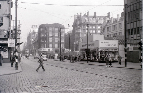
Here we have the present day monstrosity - Shawlands Arcade.

- TheOutSider
- Busy bunny
- Posts: 10
- Joined: Wed Apr 09, 2008 9:15 am
Re: Past Present Vol 2
![]() by TheOutSider » Mon Mar 23, 2009 9:02 pm
by TheOutSider » Mon Mar 23, 2009 9:02 pm

- TheOutSider
- Busy bunny
- Posts: 10
- Joined: Wed Apr 09, 2008 9:15 am
Re: Past Present Vol 2
![]() by TheOutSider » Mon Mar 23, 2009 9:10 pm
by TheOutSider » Mon Mar 23, 2009 9:10 pm

Here is a modern day equivalent from 2009. The trees get in the way a bit!

- TheOutSider
- Busy bunny
- Posts: 10
- Joined: Wed Apr 09, 2008 9:15 am
Re: Past Present Vol 2
![]() by TheOutSider » Mon Mar 23, 2009 9:15 pm
by TheOutSider » Mon Mar 23, 2009 9:15 pm

The 2009 equivalent for Grantly Gardens, Shawlands.

- TheOutSider
- Busy bunny
- Posts: 10
- Joined: Wed Apr 09, 2008 9:15 am
Return to Hidden Glasgow Projects
Who is online
Users browsing this forum: No registered users and 12 guests