At Blantyre the piers of the Craighead Viaduct the first major project of Sir Wm Arrol Ltdof Dalmarock Iron Works are to be demolished for housing.
Although unlisted and just the piers remain of this viaduct constructed for the Hamilton & Bothwell line of the North British Railway they are fine historic examples of scottish engineering and many people in the area will be sad to see them go.
The Hidden Glasgow Forums
To post in the forums you will need to first register. All new members are welcomed, with one caveat: You must behave and be nice AND SEARCH BEFORE POSTING!
Sir William Arrol Viaduct Piers Blantyre --- soon to go
Moderators: John, Sharon, Fossil, Lucky Poet, crusty_bint, Jazza, dazza
21 posts
• Page 1 of 2 • 1, 2
Sir William Arrol Viaduct Piers Blantyre --- soon to go
![]() by junkcatcher » Sun Jan 14, 2007 11:47 am
by junkcatcher » Sun Jan 14, 2007 11:47 am
Andy
- junkcatcher
- First Stripe

- Posts: 73
- Joined: Sun Oct 22, 2006 12:10 pm
![]() by My Word » Sun Jan 14, 2007 11:03 pm
by My Word » Sun Jan 14, 2007 11:03 pm
I'm greatly interested in industrial acrhitecture, especially remnants of railway lines - can you define the location a bit more for a non-local so I can get a photo or two before demolition ?
-

My Word - First Stripe
- Posts: 78
- Joined: Sat Dec 30, 2006 8:52 pm
- Location: The Big Whitbread hoose.
![]() by Fossil » Sun Jan 14, 2007 11:13 pm
by Fossil » Sun Jan 14, 2007 11:13 pm
My Word wrote:I'm greatly interested in industrial acrhitecture, especially remnants of railway lines - can you define the location a bit more for a non-local so I can get a photo or two before demolition ?
aye good idea!
Bum tit tit bum tit tit play yer hairy banjo
-

Fossil - -

- Posts: 12310
- Joined: Sun Feb 08, 2004 12:07 am
- Location: Pitt Street
![]() by scallopboy » Sun Jan 14, 2007 11:28 pm
by scallopboy » Sun Jan 14, 2007 11:28 pm
Some pointers for you. Remember and post those all important pics 
http://www.railscot.co.uk/Glasgow_Bothw ... /frame.htm
http://www.streetmap.co.uk/newmap.srf?x ... search.srf
http://www.railscot.co.uk/Glasgow_Bothw ... /frame.htm
http://www.streetmap.co.uk/newmap.srf?x ... search.srf
-

scallopboy - Third Stripe

- Posts: 1325
- Joined: Sun Jul 03, 2005 5:34 pm
- Location: Strathbungo
![]() by gap74 » Mon Jan 15, 2007 6:23 am
by gap74 » Mon Jan 15, 2007 6:23 am
There's an article in the Hamilton Advertiser this week reporting on a few lone voices in the wilderness who want these to stay:
http://iclanarkshire.icnetwork.co.uk/ha ... _page.html
You can see them on the aerial pic in this link here:
http://maps.live.com/default.aspx?v=2&c ... &alt=-1000
The industrial estate just visible at the bottom of the screen is Whistleberry, at the eastern end of Blantyre. If anyone is heading off out to see these, give me a shout, I'll gladly tag along!
Incidentally, there's another impressive set of piers crossing the Rotten Calder river in High Blantyre, which once carried the line between East Kilbride and Blantyre. Aerial shot of it here:
http://maps.live.com/default.aspx?v=2&c ... &alt=-1000
Gary
-

gap74 - Third Stripe
- Posts: 1532
- Joined: Thu Mar 18, 2004 12:33 am
![]() by My Word » Mon Jan 15, 2007 10:22 pm
by My Word » Mon Jan 15, 2007 10:22 pm
Thanks for the advice I notice its off the EK Expressway, and where I'll be coming from I'll have to come off and travel back to get near it.
Had a look at the pic on Ewan Crawford's website, a typical example of a viaduct on that line, the engineers seemed to prefer a basic type of structure for the contractors to build, mecanno style almost. Still, the piers are impressive, no doubt about that.
Had a look at the pic on Ewan Crawford's website, a typical example of a viaduct on that line, the engineers seemed to prefer a basic type of structure for the contractors to build, mecanno style almost. Still, the piers are impressive, no doubt about that.
-
My Word - First Stripe
- Posts: 78
- Joined: Sat Dec 30, 2006 8:52 pm
- Location: The Big Whitbread hoose.
![]() by junkcatcher » Tue Jan 16, 2007 11:12 am
by junkcatcher » Tue Jan 16, 2007 11:12 am
if anything the ones in the park at High Blantyre are even more impressive bits of stone work --- very tall and slender.
Andy
- junkcatcher
- First Stripe
- Posts: 73
- Joined: Sun Oct 22, 2006 12:10 pm
![]() by Squigster » Tue Jan 16, 2007 8:07 pm
by Squigster » Tue Jan 16, 2007 8:07 pm
if anything the ones in the park at High Blantyre are even more impressive bits of stone work --- very tall and slender.
Being a High Blantyre lad, I can remember being taken walks as a youngster by these pillars and being absolutley amazed as to how they could be built.
-

Squigster - Second Stripe

- Posts: 332
- Joined: Fri Sep 09, 2005 7:11 pm
- Location: Partick
Re: Sir William Arrol Viaduct Piers Blantyre --- soon to go
![]() by Tim » Sat Apr 05, 2008 1:46 am
by Tim » Sat Apr 05, 2008 1:46 am
Did anyone manage photos of the piers at all? Am particularly interested in the High Blantyre ones if anyone has them on camera 
Cheers,
Tim
Cheers,
Tim
- Tim
- Just settling in

- Posts: 2
- Joined: Sat Apr 05, 2008 1:43 am
- Location: Somewhere in the UK
Re: Sir William Arrol Viaduct Piers Blantyre --- soon to go
![]() by gap74 » Sat Apr 05, 2008 2:21 am
by gap74 » Sat Apr 05, 2008 2:21 am
Give me a couple of days, I take the dog up near there fairly regularly, I'll make the minor diversion to these with my camera - pleasant stroll along the Rotten Calder it is too! Never did make it to the ones mooted for demolition, anyone know if they've gone yet?
-
gap74 - Third Stripe
- Posts: 1532
- Joined: Thu Mar 18, 2004 12:33 am
Re: Sir William Arrol Viaduct Piers Blantyre --- soon to go
![]() by Jay23 » Mon Apr 28, 2008 5:48 pm
by Jay23 » Mon Apr 28, 2008 5:48 pm
The regular rail service closed in 1952 but some trains still used it for several years. I remember well crossing it by the underslung footpath, wheeling my bike, with its tyres slipping through the cracks in the planking, and an engine crossing overhead. Terrifying! 
I think that the footpath was officially closed but people still used it. My friends and I visited it many times from Hamilton in 1955 and 1956. After the rails were removed, the top deck was used as a footpath for several years and I think I once saw a car crossing it.
I think that the footpath was officially closed but people still used it. My friends and I visited it many times from Hamilton in 1955 and 1956. After the rails were removed, the top deck was used as a footpath for several years and I think I once saw a car crossing it.
- Jay23
- Just settling in
- Posts: 3
- Joined: Mon Apr 28, 2008 5:31 pm
Re: Sir William Arrol Viaduct Piers Blantyre --- soon to go
![]() by Tim » Sun May 04, 2008 1:42 am
by Tim » Sun May 04, 2008 1:42 am
gap74 wrote:Give me a couple of days, I take the dog up near there fairly regularly, I'll make the minor diversion to these with my camera - pleasant stroll along the Rotten Calder it is too! Never did make it to the ones mooted for demolition, anyone know if they've gone yet?
Any luck there then?
Jay23 wrote:The regular rail service closed in 1952 but some trains still used it for several years. I remember well crossing it by the underslung footpath, wheeling my bike, with its tyres slipping through the cracks in the planking, and an engine crossing overhead. Terrifying!
I think that the footpath was officially closed but people still used it. My friends and I visited it many times from Hamilton in 1955 and 1956. After the rails were removed, the top deck was used as a footpath for several years and I think I once saw a car crossing it.
Fantastic memories there
Cheers,
Tim
- Tim
- Just settling in
- Posts: 2
- Joined: Sat Apr 05, 2008 1:43 am
- Location: Somewhere in the UK
Re: Sir William Arrol Viaduct Piers Blantyre --- soon to go
![]() by gap74 » Mon May 05, 2008 3:05 am
by gap74 » Mon May 05, 2008 3:05 am
Tim wrote:Any luck there then?
Was on my way there last week when I got caught in that thunder and lightning and hail business, so only made it as far as the old WWII AA gunsite on Blantyreferme Rd.
There's still one of the old lattice girder bridges in the area, the one over the Clyde between Carmyle and Westburn - although Christ knows why they retain it still, it's not like it'll ever be load-bearing again in its life, and the approach embankment from the Westburn/Newton side has been partially removed to stop folk walking across it, after the tragic drowning of a kid 12 or so years ago.
I've got plenty of pics of that if you're interested!
-
gap74 - Third Stripe
- Posts: 1532
- Joined: Thu Mar 18, 2004 12:33 am
Re: Sir William Arrol Viaduct Piers Blantyre --- soon to go
![]() by gap74 » Wed May 07, 2008 4:35 pm
by gap74 » Wed May 07, 2008 4:35 pm
OK, made it up here yesterday in the blazing sunshine, which was lovely for walks but made photography a little irksome. Here are some shots that didn't turn out too badly - half of the rest were taken looking directly into the sun, so don't show much other than shadow!
NOTE: These are the High Blantyre ones, not the ones over the Clyde referred to in the thread title - they're next on my list, if they're still there!
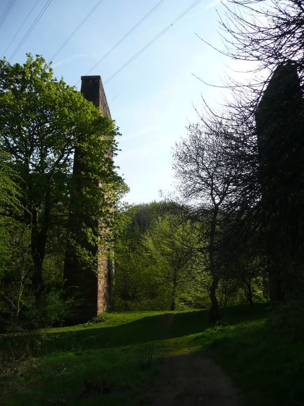
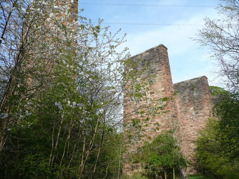
As you walk up the path from the wee bridge over the Calder at Millheugh, this is your first sight of the pillars, and what muckle beasts they are too. As far as I can gather, this line is a continuation of the one that currently runs from Glasgow to East Kilbride, it once having continued through Nerston and just north of where Whirlies roundabout is, through fields alongside Stoneymeadow Road and Crossbasket House, over this viaduct into High Blantyre where it joined up with the Hamilton and Strathaven railway just after High Blantyre station.
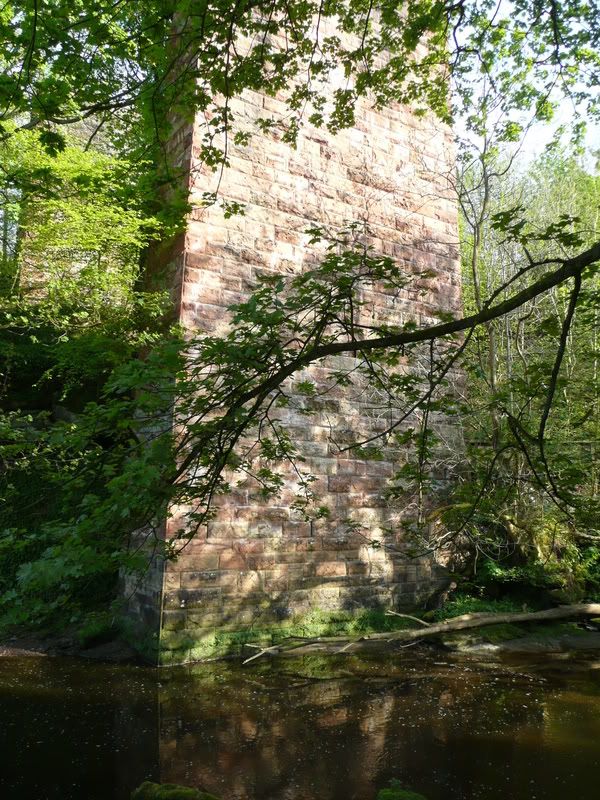
This is probably the tallest pillar, sitting as it does in the eastern bank of the Rotten Calder. The bank rises very sharply on that side, so there's only one more pillar beyond this one, high up on the ravine above, in contrast to the gentler slope behind where I'm standing - I think there are about ten or so pillars in all, two to the east of the river, and eight to the west. I'll think to count them next time!
Evidence of climbing equipment on the side of this one, guess it makes good practice! According to the excellent Railscot site, the line was built around 1868, this section having closed between 1914 and 1923. It then re-opened, only to close permanently to passenger traffic a year later, and to freight traffic in 1935. So it's now been adanboned for 73 years, 6 years longer than it operated for!
There is still much evidence of the line between here and west towards East Kilbride, although a section through Nerston has been completely lost to industrial estates and the like.
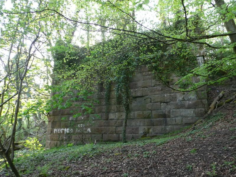
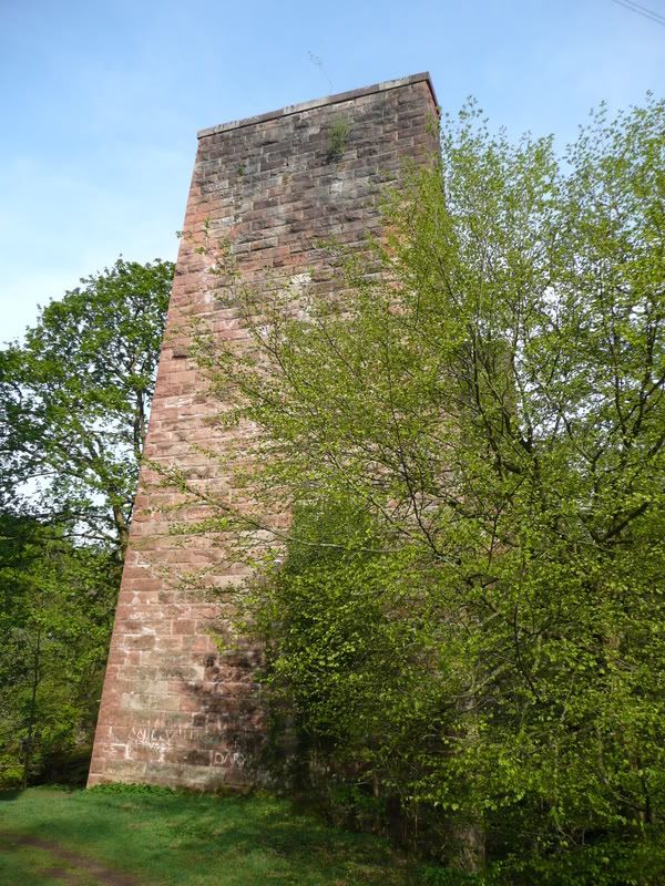
This is where the western side of the viaduct where it hits terra firma, very overgrown now and in the middle of thick woods. The line then enters a wide cutting, with some brick wall structures evident a few hundred metres along, no idea what they are though. Only seems to be a pond behind them.
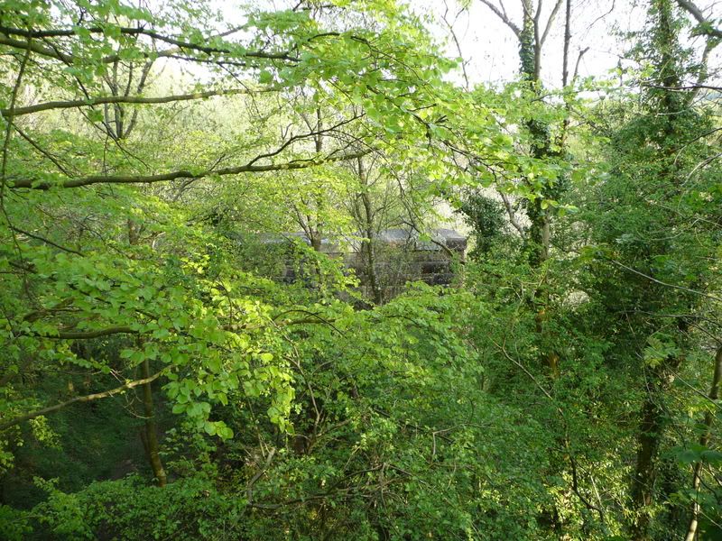
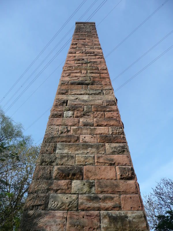
The view from the top of the terminal end of the viaduct, not quite as impressive as it could be due to the tree growth, but you can see the top of the first pillar easily enough. The cutting behind me goes through woods, as I've mentioned, and emerges briefly before going into another cutting across fields behind Crossbasket House.
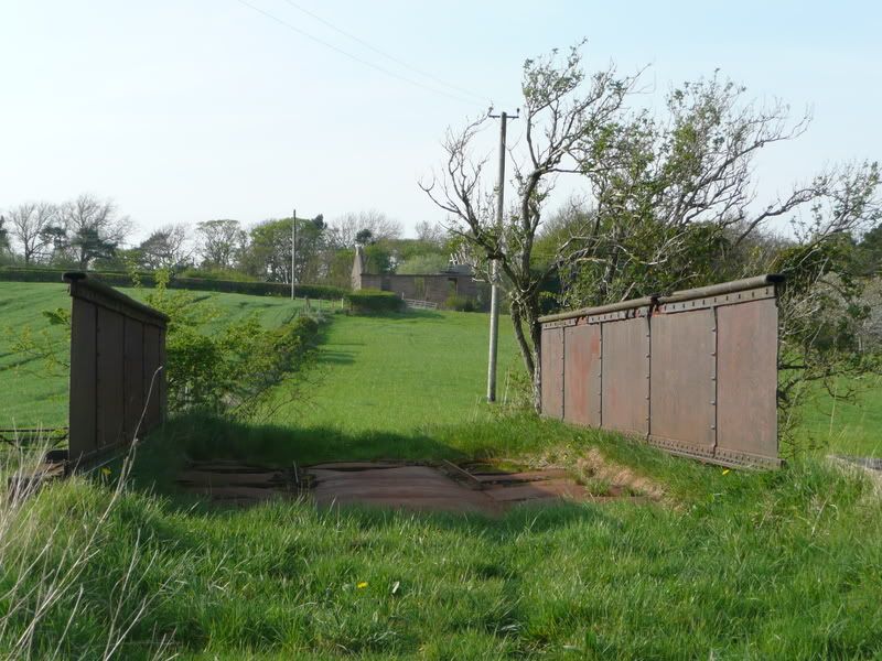
There are two of these wee bridges over the cutting, presumably for farm access. This one is looking worse for wear, with time having robbed it of its stone walls, and rust eating some rather worrying holes in the deck.
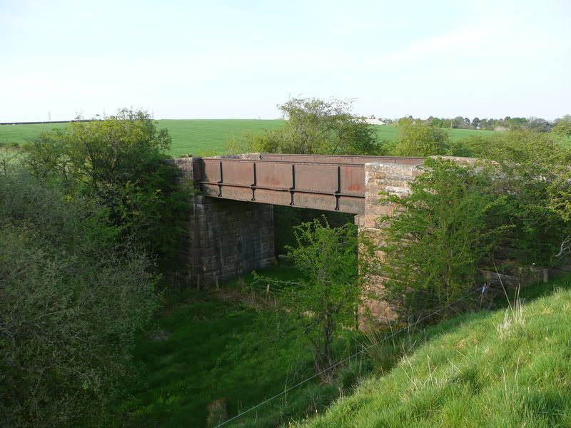
This one is just slightly further west, and in better shape. Strangely, telegraph poles carrying still live wires follow the line here, I'm guessing to serve the farmhouses nearby. It then crossed Flemington Road, near the junction with Stoneymeadow Road, although the supporting walls and bridge have all been removed. Beyond that, it runs on an embankment then a cutting before crossing Stoneymeadow Road on another impressively high bridge, the support walls of which remain. Again, very impressive industrial remains, but I never have my camera with me when I'm there. Give me another week or two!
NOTE: These are the High Blantyre ones, not the ones over the Clyde referred to in the thread title - they're next on my list, if they're still there!
As you walk up the path from the wee bridge over the Calder at Millheugh, this is your first sight of the pillars, and what muckle beasts they are too. As far as I can gather, this line is a continuation of the one that currently runs from Glasgow to East Kilbride, it once having continued through Nerston and just north of where Whirlies roundabout is, through fields alongside Stoneymeadow Road and Crossbasket House, over this viaduct into High Blantyre where it joined up with the Hamilton and Strathaven railway just after High Blantyre station.
This is probably the tallest pillar, sitting as it does in the eastern bank of the Rotten Calder. The bank rises very sharply on that side, so there's only one more pillar beyond this one, high up on the ravine above, in contrast to the gentler slope behind where I'm standing - I think there are about ten or so pillars in all, two to the east of the river, and eight to the west. I'll think to count them next time!
Evidence of climbing equipment on the side of this one, guess it makes good practice! According to the excellent Railscot site, the line was built around 1868, this section having closed between 1914 and 1923. It then re-opened, only to close permanently to passenger traffic a year later, and to freight traffic in 1935. So it's now been adanboned for 73 years, 6 years longer than it operated for!
There is still much evidence of the line between here and west towards East Kilbride, although a section through Nerston has been completely lost to industrial estates and the like.
This is where the western side of the viaduct where it hits terra firma, very overgrown now and in the middle of thick woods. The line then enters a wide cutting, with some brick wall structures evident a few hundred metres along, no idea what they are though. Only seems to be a pond behind them.
The view from the top of the terminal end of the viaduct, not quite as impressive as it could be due to the tree growth, but you can see the top of the first pillar easily enough. The cutting behind me goes through woods, as I've mentioned, and emerges briefly before going into another cutting across fields behind Crossbasket House.
There are two of these wee bridges over the cutting, presumably for farm access. This one is looking worse for wear, with time having robbed it of its stone walls, and rust eating some rather worrying holes in the deck.
This one is just slightly further west, and in better shape. Strangely, telegraph poles carrying still live wires follow the line here, I'm guessing to serve the farmhouses nearby. It then crossed Flemington Road, near the junction with Stoneymeadow Road, although the supporting walls and bridge have all been removed. Beyond that, it runs on an embankment then a cutting before crossing Stoneymeadow Road on another impressively high bridge, the support walls of which remain. Again, very impressive industrial remains, but I never have my camera with me when I'm there. Give me another week or two!
-
gap74 - Third Stripe
- Posts: 1532
- Joined: Thu Mar 18, 2004 12:33 am
Re: Sir William Arrol Viaduct Piers Blantyre --- soon to go
![]() by gap74 » Wed May 07, 2008 4:46 pm
by gap74 » Wed May 07, 2008 4:46 pm
Incidentally, if anyone knows where High Blantyre station was in relation to what's currently there, and where the East Kilbride and Strathaven lines met, I'd be curious to know - the track is impossible to follow on aerial mapping sites due to modern development!
-
gap74 - Third Stripe
- Posts: 1532
- Joined: Thu Mar 18, 2004 12:33 am
21 posts
• Page 1 of 2 • 1, 2
Who is online
Users browsing this forum: No registered users and 11 guests