Coatbridge Area

Moderators: John, Sharon, Fossil, Lucky Poet, crusty_bint, Jazza, dazza

Coatbridge Area

Postby StevenJ » Sun Jan 08, 2006 8:40 pm

Was being generally nosey in the Coatbridge area on Saturday afternoon, and came accross:

Image

Image

Image

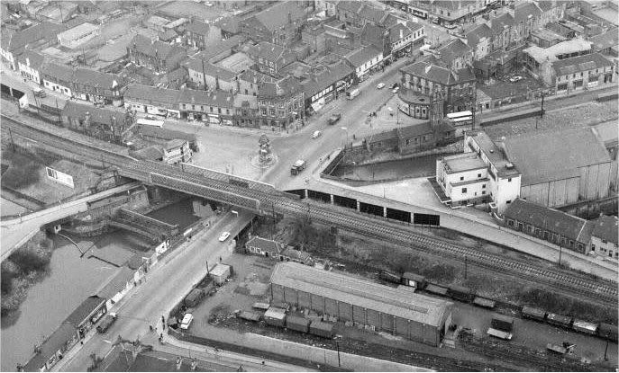
It looks like it could be old railway property or old canalways? Just next to Coatbridge Central, Can anyone tell me what used to be here?
User avatar
StevenJ
Second Stripe
Second Stripe
 
Posts: 211
Joined: Sun Jun 27, 2004 8:54 pm
Location: York

Postby james73 » Sun Jan 08, 2006 9:11 pm

Great pics. No idea what is was, but it could've been part of the Monkland
Canal?


James H
james73
Third Stripe
Third Stripe
 
Posts: 2035
Joined: Wed Dec 17, 2003 4:08 pm
Location: urbanglasgow.co.uk - come & join us.....

Postby Schiehallion » Sun Jan 08, 2006 9:18 pm

I would say it's the old route of the Monkland Canal.

Image

You can see on this map where the canal would continue south-east below Blairhill before turning north-east towards the station. It would've made sense to build the station next to the canal.
User avatar
Schiehallion
Third Stripe
Third Stripe
 
Posts: 1625
Joined: Sat Mar 20, 2004 9:32 pm

Postby StevenJ » Sun Jan 08, 2006 11:07 pm

it's not quite the location you suggest - I have done a map where the photos were taken

Image

Arrow 1 shows where the second picture is taken from
Arrow 2 shows where the last picture is taken from

The other picture is just from under the road bridge......
User avatar
StevenJ
Second Stripe
Second Stripe
 
Posts: 211
Joined: Sun Jun 27, 2004 8:54 pm
Location: York

Nun Aloud

Postby Dexter St. Clair » Mon Jan 09, 2006 12:52 am

Picture 1 shows a tow path.

The Map shows a Canal treet therefore it must be a secret tunnel leading to a Catholics Only Nuclear Shelter.
User avatar
Dexter St. Clair
Third Stripe
Third Stripe
 
Posts: 6252
Joined: Tue Nov 16, 2004 9:54 pm

Postby Alycidon » Mon Jan 09, 2006 7:55 am

Now you are venturing into my territory. The top two pictures are of the original route of the Monkland Canal. It was filled in around 1964 but the water still flows through buried pipes to feed the Forth and Clyde Canal in Glasgow. The short pedestrian tunnel connected the platforms on the original Coatbridge Central (LNER) station which was situated on the line above. Full description on http://www.jhowie.f9.co.uk/coatbridge.htm
More about the Monkland Canal and a small photograph of the canal at StevenJ's location when still filled with water
http://www.monklands.co.uk/features/monklandcanal.htm
User avatar
Alycidon
Third Stripe
Third Stripe
 
Posts: 1047
Joined: Mon Apr 18, 2005 11:11 am
Location: Eaglesham

Re: Nun Aloud

Postby Schiehallion » Mon Jan 09, 2006 10:46 am

Dexter St. Clair wrote:it must be a secret tunnel leading to a Catholics Only Nuclear Shelter.


To hide from the weapons of MASS destruction.

Right, whit jaiket's mine.
User avatar
Schiehallion
Third Stripe
Third Stripe
 
Posts: 1625
Joined: Sat Mar 20, 2004 9:32 pm

Postby Alycidon » Mon Jan 09, 2006 11:02 am

Just as well they filled in the canal, there would have been plenty in Coatbridge wanting to jump in yesterday afternoon. After all they would not have wanted to jump in the Clyde! ::):
User avatar
Alycidon
Third Stripe
Third Stripe
 
Posts: 1047
Joined: Mon Apr 18, 2005 11:11 am
Location: Eaglesham

Postby Alycidon » Mon Jan 09, 2006 11:17 am

Here is an arial view of the vicinity, the pedestrian tunnel is just above and to the left of the advertising hoarding in the middle left of the photograph, originally it gave access to the station building which was on the opposite side of the tracks. The canal runs from the bottom left of the photograph and the photographs show the old bed of the "Gartsherrie and Hornock Cut", just off to the left of the ariel view.

Image
User avatar
Alycidon
Third Stripe
Third Stripe
 
Posts: 1047
Joined: Mon Apr 18, 2005 11:11 am
Location: Eaglesham

Postby lordsleek » Mon Jan 09, 2006 5:40 pm

whats the date of that foty alicydon? good of the cinema too.
eeeeeewwwww whats that!
Can I touch it?
User avatar
lordsleek
Third Stripe
Third Stripe
 
Posts: 477
Joined: Tue Feb 15, 2005 11:43 am
Location: Uddingston

Postby Alycidon » Mon Jan 09, 2006 7:15 pm

Hi Lordsleek

It's might be off the Scran site, given to me by a big laddie that ran away without telling me about any copyright, taken 19th February 1960 (The Scotsman Publications Ltd)
User avatar
Alycidon
Third Stripe
Third Stripe
 
Posts: 1047
Joined: Mon Apr 18, 2005 11:11 am
Location: Eaglesham

Postby lordsleek » Mon Jan 09, 2006 8:02 pm

hehe I hate when that happens
eeeeeewwwww whats that!
Can I touch it?
User avatar
lordsleek
Third Stripe
Third Stripe
 
Posts: 477
Joined: Tue Feb 15, 2005 11:43 am
Location: Uddingston

Postby StevenJ » Mon Jan 09, 2006 10:07 pm

lordsleek wrote:whats the date of that foty alicydon? good of the cinema too.


this was the cinema on Saturday...........

Image
User avatar
StevenJ
Second Stripe
Second Stripe
 
Posts: 211
Joined: Sun Jun 27, 2004 8:54 pm
Location: York

Postby tommytank » Wed Jan 11, 2006 2:17 pm

what happened to the canal then? why did they drain it?
tommytank
Second Stripe
Second Stripe
 
Posts: 187
Joined: Sun Nov 06, 2005 9:05 pm
Location: Glasweegie again!

Postby Alycidon » Wed Jan 11, 2006 4:01 pm

The canal had fallen out of use well before WW2 and it became a rat infested death trap for children. Following a successful campaign the process to fill in the canal started in 1964 beginning with the sections between Sheepford (Coatdyke, Locks Street) and Drumpellier and Easterhouse and Glasgow City Centre. The section from Calderbank to Sheepford was fill in at a later date.
The canal still exists through Drumpellier Park and the flow of water is maintained by underground pipes that feed the Forth and Clyde at Port Dundas
User avatar
Alycidon
Third Stripe
Third Stripe
 
Posts: 1047
Joined: Mon Apr 18, 2005 11:11 am
Location: Eaglesham

Next

Return to Glasgow Chat (Coffee Lounge)

Who is online

Users browsing this forum: No registered users and 22 guests