Harmsworth Street bridge ......gone!

Going!

Going!!

Gone!!!

To post in the forums you will need to first register. All new members are welcomed, with one caveat: You must behave and be nice AND SEARCH BEFORE POSTING!
Moderators: John, Sharon, Fossil, Lucky Poet, crusty_bint, Jazza, dazza
![]() by Pgcc93 » Wed Jun 08, 2005 6:46 pm
by Pgcc93 » Wed Jun 08, 2005 6:46 pm
Modern Fossil wrote:I hope you got the sign PGCC

Fossil

![]() by Alycidon » Wed Jun 08, 2005 7:27 pm
by Alycidon » Wed Jun 08, 2005 7:27 pm

![]() by Vladimir » Wed Jun 08, 2005 7:43 pm
by Vladimir » Wed Jun 08, 2005 7:43 pm

![]() by james73 » Wed Jun 08, 2005 10:56 pm
by james73 » Wed Jun 08, 2005 10:56 pm
Alycidon wrote:
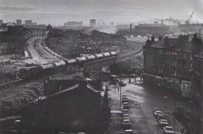
From George C O'Hara's book "Scottish Urban and Rural Branch Lines" April 1976
![]() by Return of UUU » Tue Jun 14, 2005 9:33 pm
by Return of UUU » Tue Jun 14, 2005 9:33 pm
Vladimir wrote: Would it not be kind of useful if that line was still in operation, given the transoprt needs for that area

![]() by radar » Tue Jun 14, 2005 11:20 pm
by radar » Tue Jun 14, 2005 11:20 pm


![]() by Flyingscot » Wed Jun 15, 2005 9:01 pm
by Flyingscot » Wed Jun 15, 2005 9:01 pm

![]() by Vinny the Mackem » Fri Jun 17, 2005 4:34 pm
by Vinny the Mackem » Fri Jun 17, 2005 4:34 pm

Return to Glasgow Chat (Coffee Lounge)
Users browsing this forum: Google [Bot] and 44 guests