Alex.
The Hidden Glasgow Forums
To post in the forums you will need to first register. All new members are welcomed, with one caveat: You must behave and be nice AND SEARCH BEFORE POSTING!
Finmeoot
Moderators: John, Sharon, Fossil, Lucky Poet, crusty_bint, Jazza, dazza

![]() by gap74 » Thu Jun 16, 2005 11:00 pm
by gap74 » Thu Jun 16, 2005 11:00 pm
The plot thickens!
Wonder what they were built for and when? If they pre-date WWII, as the date of the pic suggests, I can't think what was around there that they would serve - the AA-gun emplacement along the road looks very definitely like a WWII structure so wouldn't have been there, unless he has the date of the pic wrong...
Just resizing all my pics of the place to stick up....
Gary
-

gap74 - Third Stripe

- Posts: 1532
- Joined: Thu Mar 18, 2004 12:33 am
![]() by Captain Brittles » Thu Jun 16, 2005 11:15 pm
by Captain Brittles » Thu Jun 16, 2005 11:15 pm
Post removed
Last edited by Captain Brittles on Fri Jul 01, 2005 10:50 pm, edited 1 time in total.
-

Captain Brittles - Third Stripe
- Posts: 531
- Joined: Fri Feb 25, 2005 1:05 am
- Location: The Gleneagles front
![]() by gap74 » Fri Jun 17, 2005 12:22 am
by gap74 » Fri Jun 17, 2005 12:22 am
Indeedy Cap'n - where did you get the info that this was around here?
It might explain why the place is so hidden...
Have resized and hosted all my pics but cannae be arsed writing captions and posting them tonight, so they'll appear tomorrow!
Gary
It might explain why the place is so hidden...
Have resized and hosted all my pics but cannae be arsed writing captions and posting them tonight, so they'll appear tomorrow!
Gary
-
gap74 - Third Stripe
- Posts: 1532
- Joined: Thu Mar 18, 2004 12:33 am
![]() by Apollo » Fri Jun 17, 2005 10:13 am
by Apollo » Fri Jun 17, 2005 10:13 am
I'm going to send a bill for my troosers and the worn out edge of my seat soon 
I have a map that shows Caldervale clearly as two rows of buildings. They're located in the space defined by a road (NOT the Westburn or Calder Road, which is a little south of it) that spurs northeast off the Blantyre Farm Road, and a fairly sharp bend in the Rotten Calder. It also shows an electricity pylon directly accross the road from the end of the buildings.
I'll try and get a grid ref off the map and/or an image I can post later.
Is this becoming an HG outing
-

Apollo - Third Stripe
- Posts: 2283
- Joined: Sun May 09, 2004 10:26 pm
- Location: Glasgow
![]() by gap74 » Fri Jun 17, 2005 10:57 am
by gap74 » Fri Jun 17, 2005 10:57 am
Oh I wouldn't get too excited, there really isn't that much left to see, and what is there is probably only of much interest to sad locals like myself...!
Nice area for a walk though, if you enjoy your industrial, agricultural and military history!
The news that the place was once army barracks and the pic posted yesterday have kinda made me more eager to document it, though, and perhaps even try to find any archive material that might exist on it. Curiously, it appears on very few maps, and when it does, it's usually just two rectangular rows in line, with no other markings - perhaps the army thing is why it seems so secretive!
Anyways, here's a pictorial overview of what's there now, split into a few posts cos there's about 23 pics!
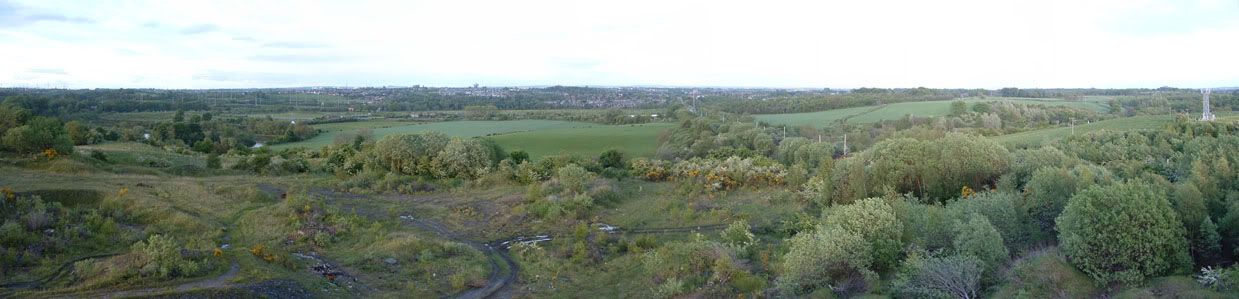
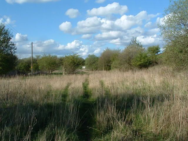
First view is a panormama I've posted elsewhere, taken from the top of the bing behind Newton Village. This gives a good overview of the area in the pics. This bing was the site of Newton Colliery, and there are remains of concrete, brick and railway structures scattered around it. I'd always presumed that Fin Me Oot was built to house workers from these pits, since this is where the path leading from it comes out - seems a rather odd place to provide a path to if no one actually works there! Anyways, on the left is the bend in the Clyde at Daldowie, snaking round past Clydeway Golf Range, which itself is built on the site of Haughead Colliery. The golf range is a long, shiny range of buildings to the left of the grassy fields in the middle distance. A line of trees leads from there to the railway line - this was another spur that served the colliery from the line between Uddingston and Newton stations, which you can see still running up the right of the pic. the lower levels of the bing are in the foreground of the pic, beyond which it drops very steeply indeed to the Rotten Calder, which flows from right to left in the pic, before joining the Clyde. If you look in the furthest away grassy field to the right of the railway line, you'll see the road to Fin Me Oot cutting across the field diagonally off Blantyre Farm Rd, which runs in front of the tree-covered hill behind that grassy field. Approach to Fin Me Oot from the point where the camera is is made by a path through the central clump of trees right in the middle of the pic.
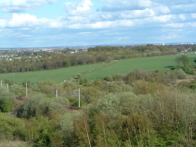
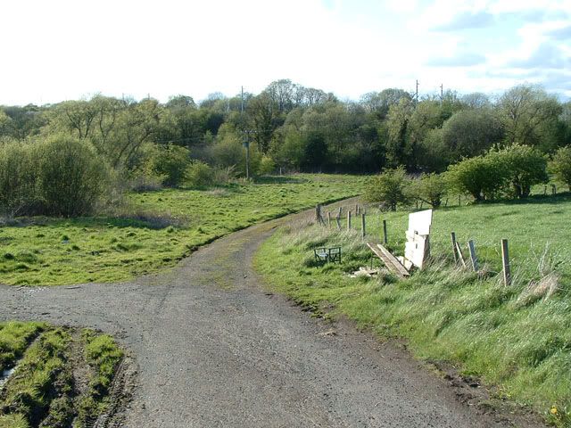
A closer shot of the tack to Fin Me Oot off Blantyre Farm Rd. You can see where the track widens at the bottom, and turns right to the flat, terraced area dug into the slope of the field. This is where the houses were. You can also just make out the bench at the bottom left of the track! Incidentally, the tree-covered hill in the distance, behind Blantyre Farm Rd, was an early example of regeneration, and was planted to cover up the remains of Blantyrefereme Brickworks and Colliery.
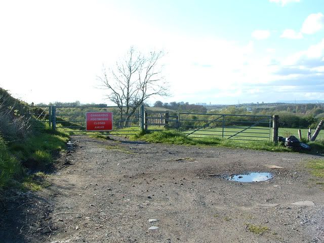
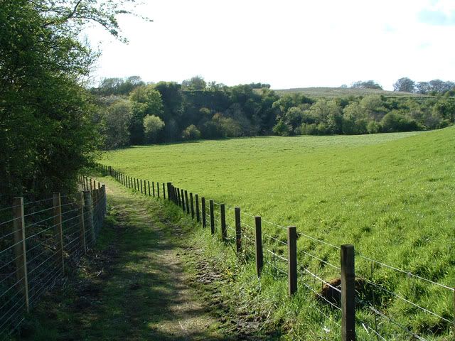
OK, switching to the opposite end now, this is the start of the track as seen from Blantyre Farm Rd - ignore the sign, which is still there, despite the bridge having been repaired.
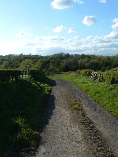
Making our way down the track from the gate in the previous pic now...
...and we reach the bench. This has been here in one form or another for at least 15 years I'd say, I think it was built by some old fellas who liked to sit and gab about the place. It's been vandalised numerous times, alas, and currently sports some rather deadly sharp nails sticking out at head height! The track here curves gently to the right and goes under the railway, whilst the branch to the left was where the houses themselves were.
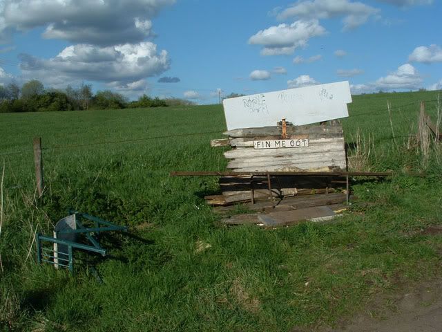
The bench itself - it used to say Caldervale above the Fin Me Oot sign.
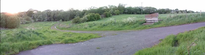
A wee panorama shot of the bench and the track that takes you under the railway.
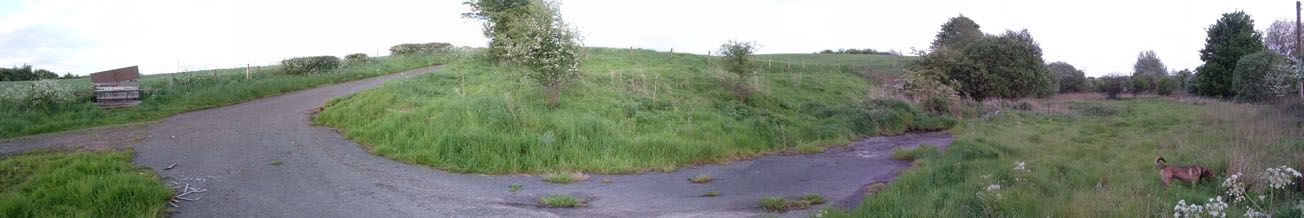
And another one showing how the flat terrace the houses were built on is dug into the slope of the field.
More soon...
Nice area for a walk though, if you enjoy your industrial, agricultural and military history!
The news that the place was once army barracks and the pic posted yesterday have kinda made me more eager to document it, though, and perhaps even try to find any archive material that might exist on it. Curiously, it appears on very few maps, and when it does, it's usually just two rectangular rows in line, with no other markings - perhaps the army thing is why it seems so secretive!
Anyways, here's a pictorial overview of what's there now, split into a few posts cos there's about 23 pics!
First view is a panormama I've posted elsewhere, taken from the top of the bing behind Newton Village. This gives a good overview of the area in the pics. This bing was the site of Newton Colliery, and there are remains of concrete, brick and railway structures scattered around it. I'd always presumed that Fin Me Oot was built to house workers from these pits, since this is where the path leading from it comes out - seems a rather odd place to provide a path to if no one actually works there! Anyways, on the left is the bend in the Clyde at Daldowie, snaking round past Clydeway Golf Range, which itself is built on the site of Haughead Colliery. The golf range is a long, shiny range of buildings to the left of the grassy fields in the middle distance. A line of trees leads from there to the railway line - this was another spur that served the colliery from the line between Uddingston and Newton stations, which you can see still running up the right of the pic. the lower levels of the bing are in the foreground of the pic, beyond which it drops very steeply indeed to the Rotten Calder, which flows from right to left in the pic, before joining the Clyde. If you look in the furthest away grassy field to the right of the railway line, you'll see the road to Fin Me Oot cutting across the field diagonally off Blantyre Farm Rd, which runs in front of the tree-covered hill behind that grassy field. Approach to Fin Me Oot from the point where the camera is is made by a path through the central clump of trees right in the middle of the pic.
A closer shot of the tack to Fin Me Oot off Blantyre Farm Rd. You can see where the track widens at the bottom, and turns right to the flat, terraced area dug into the slope of the field. This is where the houses were. You can also just make out the bench at the bottom left of the track! Incidentally, the tree-covered hill in the distance, behind Blantyre Farm Rd, was an early example of regeneration, and was planted to cover up the remains of Blantyrefereme Brickworks and Colliery.
OK, switching to the opposite end now, this is the start of the track as seen from Blantyre Farm Rd - ignore the sign, which is still there, despite the bridge having been repaired.
Making our way down the track from the gate in the previous pic now...
...and we reach the bench. This has been here in one form or another for at least 15 years I'd say, I think it was built by some old fellas who liked to sit and gab about the place. It's been vandalised numerous times, alas, and currently sports some rather deadly sharp nails sticking out at head height! The track here curves gently to the right and goes under the railway, whilst the branch to the left was where the houses themselves were.
The bench itself - it used to say Caldervale above the Fin Me Oot sign.
A wee panorama shot of the bench and the track that takes you under the railway.
And another one showing how the flat terrace the houses were built on is dug into the slope of the field.
More soon...
-
gap74 - Third Stripe
- Posts: 1532
- Joined: Thu Mar 18, 2004 12:33 am
![]() by gap74 » Fri Jun 17, 2005 11:16 am
by gap74 » Fri Jun 17, 2005 11:16 am
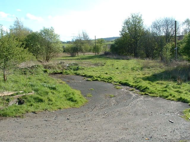
A more conventional shot of the flat terrace on which the houses stood. The road, as you can see, just stops, but beyond that, the grassy area actually masks large areas of concrete. Not sure if these are the floorpans of the houses or whatnot, or if maybe even the army rebuilt the place in a simpler form after demolishing the houses. The only structures to remain are on the left of this pic in the trees. There's a small brick hut thing, and what looks like a low retaining wall. To the right is a telegraph pole upon which you might see a jauntily angled sign!
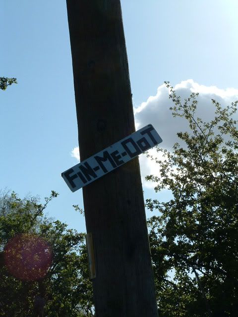
This being the sign in question...
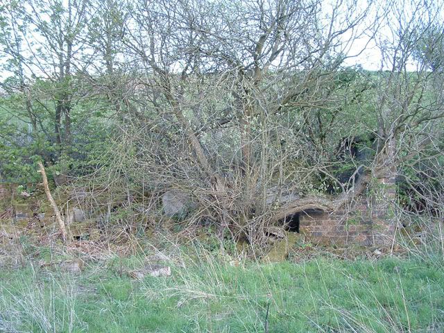
The remains of the brick hut structure, by far the closest thing to tangible remains on the site! No clues inside as to what purpose it served, think someone suggested a substation?
Right in the back corner of the village, a clothes pole and the remains of small iron fence uprights.
And a general view of the area where the houses were from the southern end of the site, looking back towards the bench.
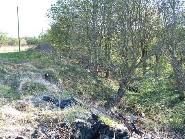
Along the western edge of the terraced area, the site drops down to a semi-circular flat plain enclosed by the Rotten Calder river. This is a fairly damp area, usually covered in wild garlic and bluebells, and is where I think the old pic posted yesterday was taken. Nowadays, it seems to get used as a dump, but note the curious dark structure in the trees at the bottom...
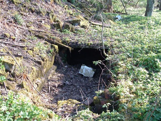
...which is this. Never been sure what this was, some kind of sewer or drain was my best guess, but now that we have an army connection, who knows!
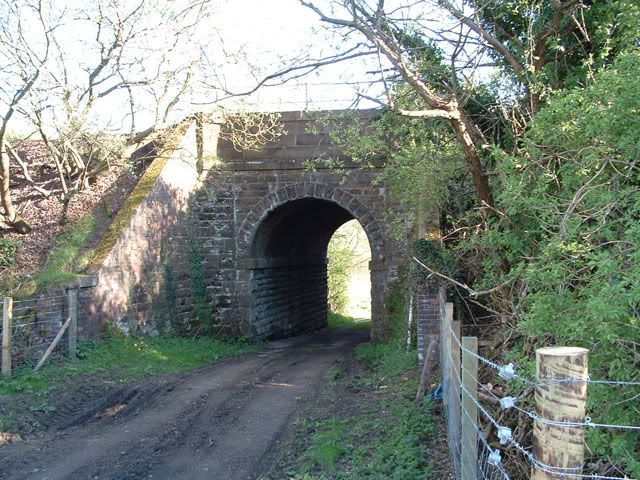
Heading off again now, we take the track under the railway, which goes under this rather smart little tunnel. This is the view from the opposite side looking back to Fin Me Oot.
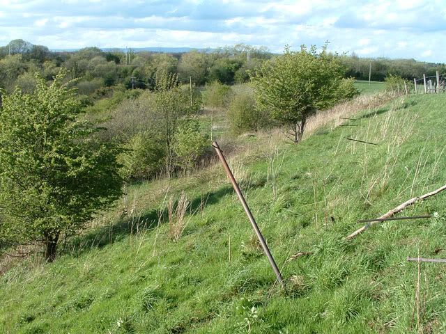
The track by now has become more of a path, which follows the railway line down towards the Rotten Calder. Note the cliffs I mentioned way back in the first pic, looming over the field in the distance.
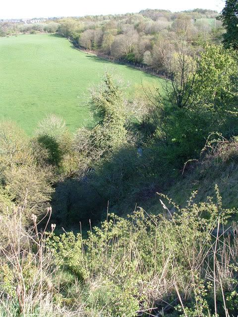
Jumping up to the cliffs for a sec, here's a view of the path from there. These cliffs are rather hairy, and subject to fairly makor subsidence, as evidenced by the large gully just in front of me as I took this pic!
More again shortly....
-
gap74 - Third Stripe
- Posts: 1532
- Joined: Thu Mar 18, 2004 12:33 am
![]() by gap74 » Fri Jun 17, 2005 11:28 am
by gap74 » Fri Jun 17, 2005 11:28 am
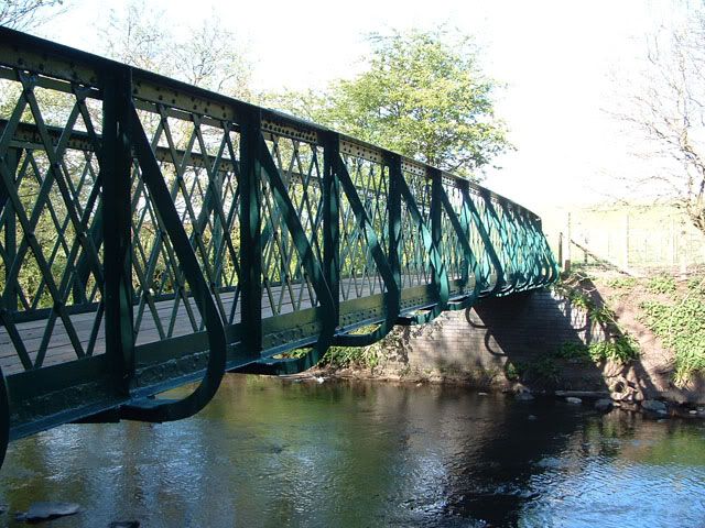
The path eventually crosses the Rotten Calder on this nice little bridge. Until recently, it had an enormous hole in the middle of it, and was rusting into the river, but they've done a not bad job of tidying it up.
The bridge crosses in the shadow of the railway embankment, which itself crosses the river on a fairly spooky canal-like tunnel.
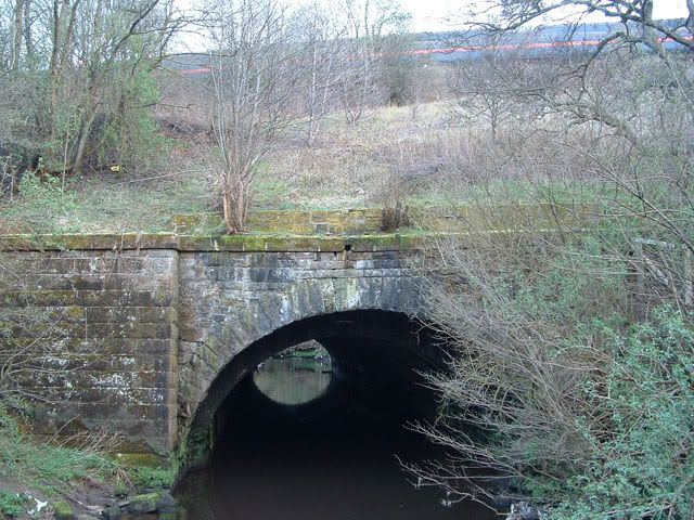
Closer up, the tunnel looks like this. An almost identical tunnel about a mile upstream carries the rail embankment between Newton and Blantyre stations over the same river.
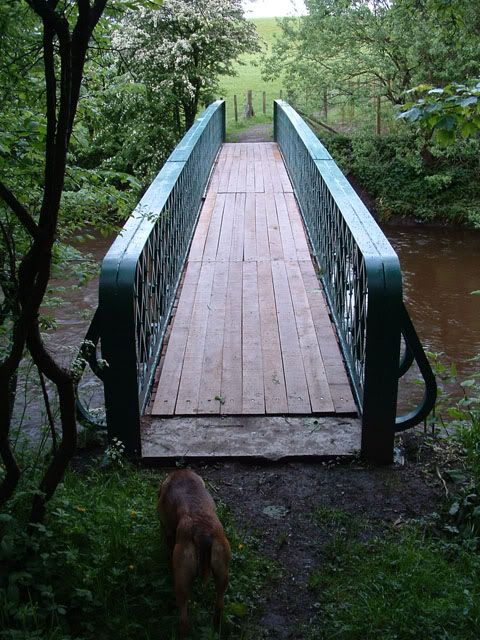
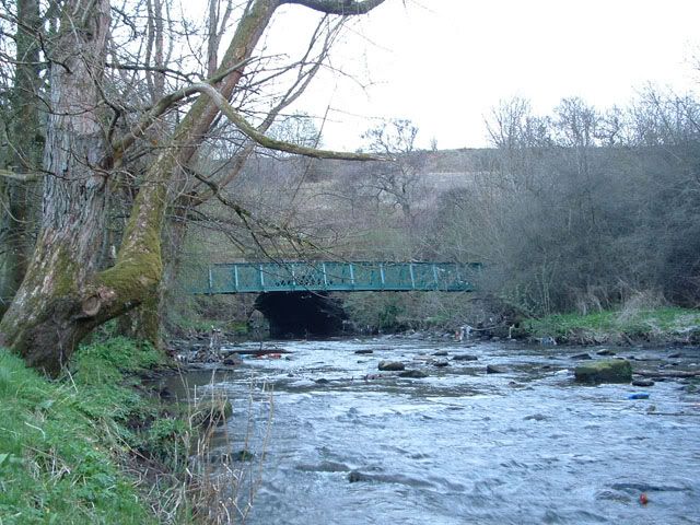
Another view of the bridge, not long after it had been repaired. The river is slightly in spate at this time, notice how rusty coloured it had become. I always thought it was called the Rotten Calder because, frankly, it stinks, but I read that it actually comes from the Gaelic for red - quite understandable, cos that's the colour it goes anytime it gets swollen.
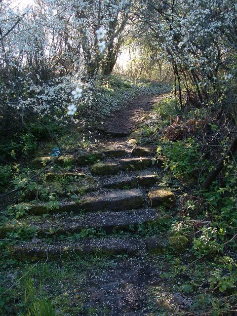
From the bridge, the path makes it way steeply up the slopes to the bing. At the start, it is stepped, but as you get further up, it gets paved by bricks, before finally just becoming a track. The stumps of an iron fence are on the right, presumably to stop drunken residents of Fin Me Oot falling down the cliffs on their way home!
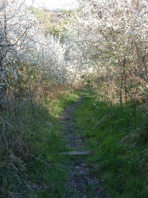
Further up the path. I was lucky enough to catch it in blossom on these days!
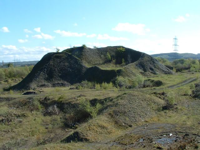
Finally, it emerges at this bing, which takes us back to the first pic. I was going to post a few pics of the colliery remains, but frankly I can't be arsed! So that's yer lot, folks.
Gary
-
gap74 - Third Stripe
- Posts: 1532
- Joined: Thu Mar 18, 2004 12:33 am
![]() by Apollo » Fri Jun 17, 2005 11:54 am
by Apollo » Fri Jun 17, 2005 11:54 am
Yes, no, and yes 
Quick snap of the map, gave enough detail so, not for the perfectionists, but here it is:

Walking through the pics, I can just about tie the two together in my head. Is that good or bad?
Quick snap of the map, gave enough detail so, not for the perfectionists, but here it is:
Walking through the pics, I can just about tie the two together in my head. Is that good or bad?
-
Apollo - Third Stripe
- Posts: 2283
- Joined: Sun May 09, 2004 10:26 pm
- Location: Glasgow


![]() by gap74 » Fri Jun 17, 2005 9:25 pm
by gap74 » Fri Jun 17, 2005 9:25 pm
Interesting - what monastic buildings were they referring to?
As I said, I'd always presumed that the place was built to house miners for the nearby pit, but the two storey buildings in the pic look perhaps more modern than I was expecting them to be - I'd be very surprised if they turned out to be older than 1900.
Now if that pic was taken in 1935, that would obviously pre-date the war. What's left on the ground today, though, looks like it possibly doesn't belong to those two storey houses. I wouldn't have expected them to have had the concrete floors that are still in situ, and what is left appears to be made of brick, whereas those houses look like they may be stone.
So I guess it could be that they were flattened and rebuilt during the war, but my dad remembers it existing, and he was born in 53, so I can't see people living in Nissen huts for 30 years! I'll ask him next time I see him if he remembers what the dwellings themselves looked like.
On the other hand, the AA gun emplacement along the road is shielded from Blantyre Farm Rd by a large embankment, which I'm fairly sure was built at the time of the emplacement itself. The entry for it in the sites and monuments register held by the RCAHMS mentions an accommodation camp:
So could this person be getting confused with this, I wonder? And how can we find out...?
Gary
As I said, I'd always presumed that the place was built to house miners for the nearby pit, but the two storey buildings in the pic look perhaps more modern than I was expecting them to be - I'd be very surprised if they turned out to be older than 1900.
Now if that pic was taken in 1935, that would obviously pre-date the war. What's left on the ground today, though, looks like it possibly doesn't belong to those two storey houses. I wouldn't have expected them to have had the concrete floors that are still in situ, and what is left appears to be made of brick, whereas those houses look like they may be stone.
So I guess it could be that they were flattened and rebuilt during the war, but my dad remembers it existing, and he was born in 53, so I can't see people living in Nissen huts for 30 years! I'll ask him next time I see him if he remembers what the dwellings themselves looked like.
On the other hand, the AA gun emplacement along the road is shielded from Blantyre Farm Rd by a large embankment, which I'm fairly sure was built at the time of the emplacement itself. The entry for it in the sites and monuments register held by the RCAHMS mentions an accommodation camp:
NS65NE 43 6818 5985
This four gun-emplacement battery is situated immediately E of the main Glasgow-London railway. Consisiting of four emplacements, ammunition lockers, command post and the GL mat (gun laying radar hexagon) to the NE. The accommodation camp was situated adjacent to the B758 public road.
Information from RCAHMS (DE) July 1997
This World War II heavy anti-aircraft battery is situated to the N of the railway line and W of Blantyre Farm Road. Consisting of six gun-emplacements, command post, magazines and a gun store all still extant, a spoil heap is now encroaching on the site and one or two other buildings are partly buried.
The battery was armed with four 4.5-inch guns.
J Guy 2001; NMRS MS 810/11, Part 3, 229-230; Vol.2 (appendix), 23
So could this person be getting confused with this, I wonder? And how can we find out...?
Gary
-
gap74 - Third Stripe
- Posts: 1532
- Joined: Thu Mar 18, 2004 12:33 am
![]() by Captain Brittles » Fri Jun 17, 2005 10:00 pm
by Captain Brittles » Fri Jun 17, 2005 10:00 pm
Post removed
Last edited by Captain Brittles on Fri Jul 01, 2005 10:57 pm, edited 1 time in total.
-
Captain Brittles - Third Stripe
- Posts: 531
- Joined: Fri Feb 25, 2005 1:05 am
- Location: The Gleneagles front
![]() by gap74 » Fri Jun 17, 2005 10:37 pm
by gap74 » Fri Jun 17, 2005 10:37 pm
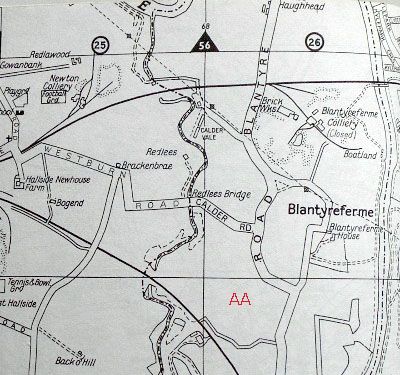
The concrete floors are actually still in situ, just hard to gauge the extent of them due to grass growing over them.
Borrowing the map above, I've marked the AA gun emplacement on it with, well, an AA!
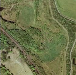
Here's an aerial pic of them as well, you can just make them out as wee grey rectangles just to the right of centre in this pic:
Gary
Borrowing the map above, I've marked the AA gun emplacement on it with, well, an AA!
Here's an aerial pic of them as well, you can just make them out as wee grey rectangles just to the right of centre in this pic:
Gary
-
gap74 - Third Stripe
- Posts: 1532
- Joined: Thu Mar 18, 2004 12:33 am
![]() by Apollo » Sat Jun 18, 2005 12:19 am
by Apollo » Sat Jun 18, 2005 12:19 am
Now why didn't I think of that 
Unfortunately, both locations fall just outside the area covered the Glasgow Photographic Atlas, so here's the link that puts Caldervale centre of the aerial pic (remember to fire up IE if you want to roam):
http://www3.getmapping.com/Preview.asp? ... 0&size=500
Unfortunately, both locations fall just outside the area covered the Glasgow Photographic Atlas, so here's the link that puts Caldervale centre of the aerial pic (remember to fire up IE if you want to roam):
http://www3.getmapping.com/Preview.asp? ... 0&size=500
-
Apollo - Third Stripe
- Posts: 2283
- Joined: Sun May 09, 2004 10:26 pm
- Location: Glasgow
Return to Glasgow Chat (Coffee Lounge)
Who is online
Users browsing this forum: No registered users and 6 guests