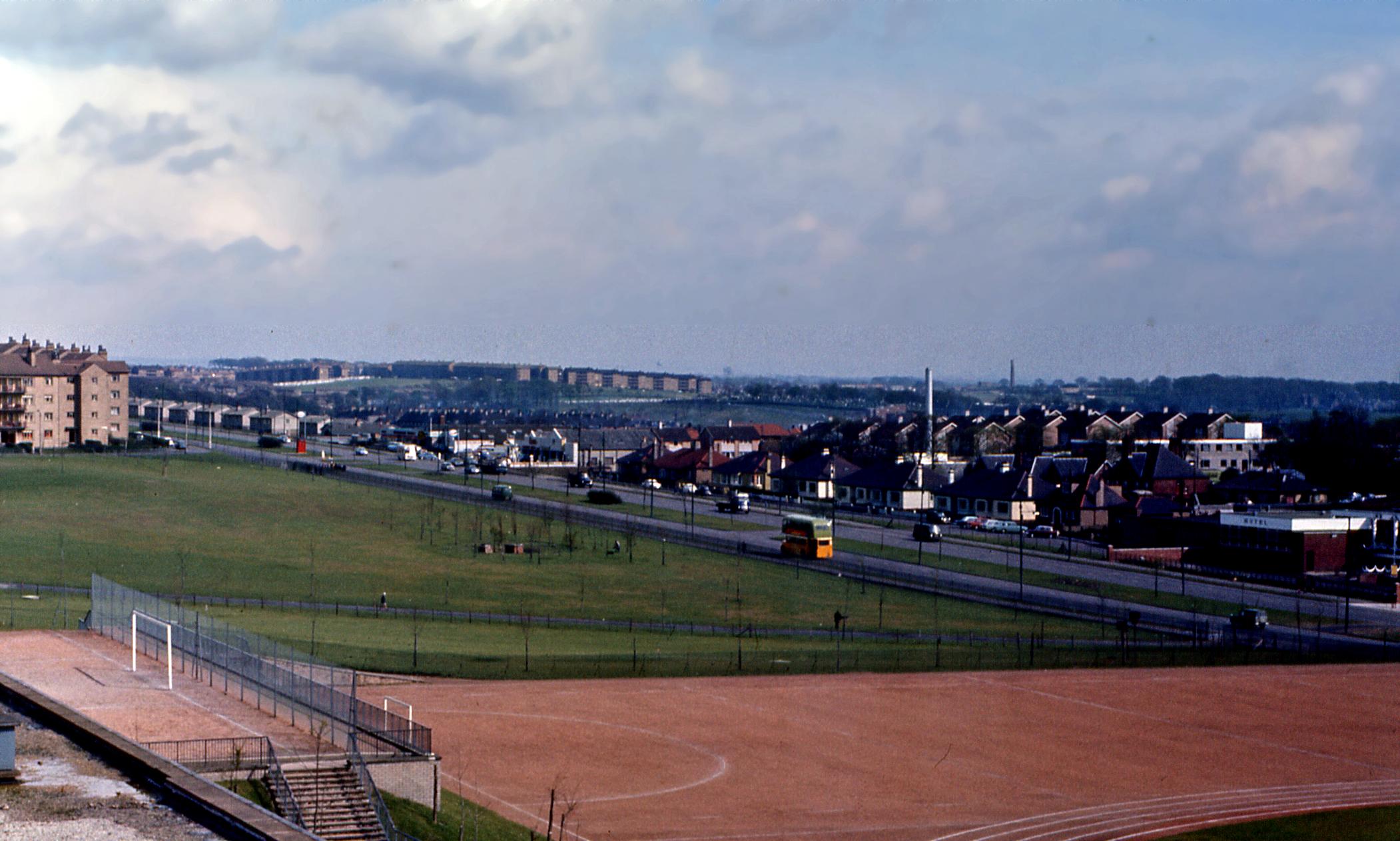
Looking South East from Cranhill in 1966
The following link is a picture on the Cranhill Wikipedia page which I believe was added only in the last couple of months.
http://upload.wikimedia.org/wikipedia/c ... lasgow.jpg
Having lived in Springboig for years I am perplexed by a couple of aspects of this picture and hope some kind, knowledgeable soul here in HiddenGlasgowLand could possible assist.
Looking behind the bus you can see two large chimneys. The white structure in the foreground is Lightburn Hospital but what is the second chimney to the right of that in the distance?
What would the red structure in the central reservation at the junction of Edinburgh Road and Carntyne Road have been?
This may seem an obvious question and using Google Earth's tracking path I am ninety percent sure but are the tenements in the left horizon at the Sandaig Road and Hallhill Road junction in Garthamlock? If that is the case then is the grassy to the bottom left of the far right tenement where the Croftspar estate built?
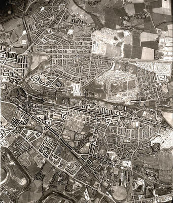
If you look over the white buildings of the Tompkin's Garage estate and the slate roof of the Springboig YMCA you see black roofs of what looks like upon first inspection tenamments. Now this doesn't look anything like the configuration of the present houses even though the following picture from The Glasgow Story of an RAF Ariel shot taken in early 1950 (only a year after the Springboig estate was completed) suggests they must be the present structures.
http://www.theglasgowstory.com/images/TGSE00504_m.jpg
As the above picture was taken sixteen years before the one at the top of my post they must be the current houses but how can they appear so different - even taking into account the renovations in the mid-eighties?
Finally - and this is a long shot - but would anyone know the story behind the world's major cities milepost that stood for years at what is now the Glasgow Private Hire offices (the right hand garage in the top picture)? I can't remember any other examples in Glasgow as a kid so have always wondered why one was placed here
Thanks in advance
Shuggy
http://upload.wikimedia.org/wikipedia/c ... lasgow.jpg
Having lived in Springboig for years I am perplexed by a couple of aspects of this picture and hope some kind, knowledgeable soul here in HiddenGlasgowLand could possible assist.
Looking behind the bus you can see two large chimneys. The white structure in the foreground is Lightburn Hospital but what is the second chimney to the right of that in the distance?
What would the red structure in the central reservation at the junction of Edinburgh Road and Carntyne Road have been?
This may seem an obvious question and using Google Earth's tracking path I am ninety percent sure but are the tenements in the left horizon at the Sandaig Road and Hallhill Road junction in Garthamlock? If that is the case then is the grassy to the bottom left of the far right tenement where the Croftspar estate built?
If you look over the white buildings of the Tompkin's Garage estate and the slate roof of the Springboig YMCA you see black roofs of what looks like upon first inspection tenamments. Now this doesn't look anything like the configuration of the present houses even though the following picture from The Glasgow Story of an RAF Ariel shot taken in early 1950 (only a year after the Springboig estate was completed) suggests they must be the present structures.
http://www.theglasgowstory.com/images/TGSE00504_m.jpg
As the above picture was taken sixteen years before the one at the top of my post they must be the current houses but how can they appear so different - even taking into account the renovations in the mid-eighties?
Finally - and this is a long shot - but would anyone know the story behind the world's major cities milepost that stood for years at what is now the Glasgow Private Hire offices (the right hand garage in the top picture)? I can't remember any other examples in Glasgow as a kid so have always wondered why one was placed here
Thanks in advance
Shuggy