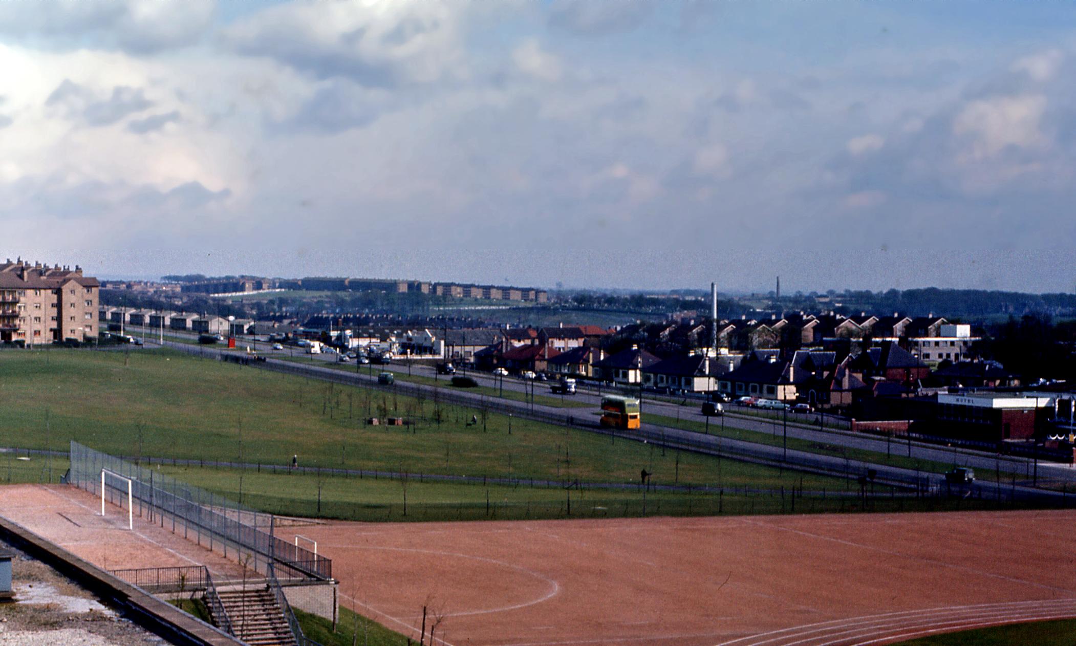
The following link is a picture on the Cranhill Wikipedia page which I believe was added only in the last couple of months.
http://upload.wikimedia.org/wikipedia/c ... lasgow.jpg
Having lived in Springboig for years I am perplexed by a couple of aspects of this picture and hope some kind, knowledgeable soul here in HiddenGlasgowLand could possible assist.
Looking behind the bus you can see two large chimneys. The white structure in the foreground is Lightburn Hospital but what is the second chimney to the right of that in the distance?
What would the red structure in the central reservation at the junction of Edinburgh Road and Carntyne Road have been?
This may seem an obvious question and using Google Earth's tracking path I am ninety percent sure but are the tenements in the left horizon at the Sandaig Road and Hallhill Road junction in Garthamlock? If that is the case then is the grassy to the bottom left of the far right tenement where the Croftspar estate built?
If you look over the white buildings of the Tompkin's Garage estate and the slate roof of the Springboig YMCA you see black roofs of what looks like upon first inspection tenamments. Now this doesn't look anything like the configuration of the present houses even though the following picture from The Glasgow Story of an RAF Ariel shot taken in early 1950 (only a year after the Springboig estate was completed) suggests they must be the present structures.
http://www.theglasgowstory.com/images/TGSE00504_m.jpg
As the above picture was taken sixteen years before the one at the top of my post they must be the current houses but how can they appear so different - even taking into account the renovations in the mid-eighties?
Finally - and this is a long shot - but would anyone know the story behind the world's major cities milepost that stood for years at what is now the Glasgow Private Hire offices (the right hand garage in the top picture)? I can't remember any other examples in Glasgow as a kid so have always wondered why one was placed here
Thanks in advance
Shuggy
The Hidden Glasgow Forums
To post in the forums you will need to first register. All new members are welcomed, with one caveat: You must behave and be nice AND SEARCH BEFORE POSTING!
Looking South East from Cranhill in 1966
Moderators: John, Sharon, Fossil, Lucky Poet, crusty_bint, Jazza, dazza
28 posts
• Page 1 of 2 • 1, 2
Looking South East from Cranhill in 1966
![]() by InkMan » Tue Jan 04, 2011 5:16 pm
by InkMan » Tue Jan 04, 2011 5:16 pm
Cleggy you snickering floppy eared hound when courage is needed, you're ne'er around.
Those medals you wear on your moth-eaten chest should be there for bungling at which you are best.
Those medals you wear on your moth-eaten chest should be there for bungling at which you are best.
-

InkMan - Second Stripe

- Posts: 322
- Joined: Sun Jul 13, 2008 12:47 pm
- Location: East Kilbride (For now!)
Re: Looking South East from Cranhill in 1966
![]() by Dexter St. Clair » Wed Jan 05, 2011 12:24 am
by Dexter St. Clair » Wed Jan 05, 2011 12:24 am
The wall was to stop clients of the six bed roomed hotel cum pub using the street as a short cut.
"I before E, except after C" works in most cases but there are exceptions.
-
Dexter St. Clair - Third Stripe

- Posts: 6252
- Joined: Tue Nov 16, 2004 9:54 pm
Re: Looking South East from Cranhill in 1966
![]() by scaryman2u » Wed Jan 05, 2011 1:06 am
by scaryman2u » Wed Jan 05, 2011 1:06 am
The red structure on Edinburgh Rd looks like a police box and if memory serves me right the Dalriada was a 7 bed roomed hotel-come pub.
-

scaryman2u - Third Stripe
- Posts: 959
- Joined: Sat Jun 24, 2006 2:22 pm
- Location: GLASGOW
Re: Looking South East from Cranhill in 1966
![]() by dimairt » Wed Jan 05, 2011 9:25 pm
by dimairt » Wed Jan 05, 2011 9:25 pm
This may seem an obvious question and using Google Earth's tracking path I am ninety percent sure but are the tenements in the left horizon at the Sandaig Road and Hallhill Road junction in Garthamlock? If that is the case then is the grassy to the bottom left of the far right tenement where the Croftspar estate built?
Sandaig Rd and Hallhill Rd are in Barlanark. Despite being a pupil of Cranhill Secondary, I don't recall the red thing on the Edinburgh Rd at all. I've e-mailed this to my brother who remembers this sort of detail.By the way,this isn't a new pic, it's been on-line for a few years.
There is /has been a similar sign-post in the Park Bar for years.
Le durachd,
Eddy
- dimairt
- Third Stripe
- Posts: 946
- Joined: Thu Jun 30, 2005 8:53 am
Re: Looking South East from Cranhill in 1966
![]() by neilmc » Wed Jan 05, 2011 11:41 pm
by neilmc » Wed Jan 05, 2011 11:41 pm
- neilmc
- Second Stripe
- Posts: 231
- Joined: Tue Sep 12, 2006 11:53 am
- Location: Glasgow, SW3
Re: Looking South East from Cranhill in 1966
![]() by Icecube » Thu Jan 06, 2011 11:20 pm
by Icecube » Thu Jan 06, 2011 11:20 pm
InkMan wrote:
Looking behind the bus you can see two large chimneys. The white structure in the foreground is Lightburn Hospital but what is the second chimney to the right of that in the distance?
What would the red structure in the central reservation at the junction of Edinburgh Road and Carntyne Road have been?
Shuggy
The other chimney stack was the one at Garrowhill brickworks at Barrachnie which must have been pulled down not long after this [brilliant] photo was taken. Using he zoom you can also faintly see [behind the Barlanark houses] the water tower at the Caterpillar factory in Tannochside and another one nearby at Viewpark.
Police boxes were normally blue but that one might have been painted red due to its location on the grass reservation.
As for the old sign - "Tokyo - 12,000mls" - who knows?
- Icecube
- Second Stripe
- Posts: 371
- Joined: Sun Jun 21, 2009 1:22 pm
Re: Looking South East from Cranhill in 1966
![]() by tickey » Fri Jan 14, 2011 9:04 pm
by tickey » Fri Jan 14, 2011 9:04 pm
as a child growin up in this area in the 70s we were always playin in the burn next to the dalriada at what was the skoda garage. the signpost i was told used to be the old boundary to glasgow thats why it was posted there at the start of edinburgh/carntyne rds. whether this is true or jus heresay im sure theres someone on here who should be able to clarify.
- tickey
- Just settling in

- Posts: 8
- Joined: Wed May 19, 2010 7:24 pm
Re: Looking South East from Cranhill in 1966
![]() by InkMan » Tue Jan 18, 2011 8:15 pm
by InkMan » Tue Jan 18, 2011 8:15 pm
Thanks for all the replies and tickey's explanation makes perfect sense considering the 1975 implementation of the Local Government (Scotland) Act 1973 saw the are transfer from the county of Lanark to Glasgow Ciry Council authority.
The black roofed tenements that I mentioned upon further inspection (as this was really pissing me off) must be those bordered by Larchgrove Road, Larchgrove Avenue and Barlanark Road. Should have picked that up earlier I suppose.
I find that here is something incredibly sad about this photograph. On the horizon there we have an estate that, like so many other areas populated by the (often necessary) housing clearances that lasted less than a lifetime. Similar to theses clearances which were still ongoing when this picture was taken the people in this estate were (in some cases once again) moved arbitrarily without much consideration of keeping families, friends or societies close. When you take into consideration the loss of the industry highlighted by the Barrachnie Brickworks and Pit then the lack of anything remotely resembling a replacement then it is no wonder that the area pictured - at times - continues to suffer from a poverty of wealth, education, health, confidence, aspiration, sustainable employment opportunities, social cohesion, amenities, affordable transport links, a society that looks down their nose at the mention of the east of Glasgow (an attitude that is prevalent in many in this City never mind the life-long Conservatives in Tory heartlands - who needs enemies with friends like that - and errrrrrr the chance of a quick pint in either the Dalriada or Stepps/Pheonix Bar ( ).
).
This is something that could be said about many Glasgow panoramas from 1966 but (a) I know the area well, (b) the image of the new housing stock rising above the centre horizon is very moving and (c) I read only recently the usual "well the health and low life expectancy issues which are amongst the worse in Europe are simply linked to a dependency on alcohol or drugs" which is strange as I have never taken the same attitude from articles concerning any other area because if they were then it would be rightly called bigoted, racist or inappropriate.
Sorry for my rant
Shuggy
The black roofed tenements that I mentioned upon further inspection (as this was really pissing me off) must be those bordered by Larchgrove Road, Larchgrove Avenue and Barlanark Road. Should have picked that up earlier I suppose.
I find that here is something incredibly sad about this photograph. On the horizon there we have an estate that, like so many other areas populated by the (often necessary) housing clearances that lasted less than a lifetime. Similar to theses clearances which were still ongoing when this picture was taken the people in this estate were (in some cases once again) moved arbitrarily without much consideration of keeping families, friends or societies close. When you take into consideration the loss of the industry highlighted by the Barrachnie Brickworks and Pit then the lack of anything remotely resembling a replacement then it is no wonder that the area pictured - at times - continues to suffer from a poverty of wealth, education, health, confidence, aspiration, sustainable employment opportunities, social cohesion, amenities, affordable transport links, a society that looks down their nose at the mention of the east of Glasgow (an attitude that is prevalent in many in this City never mind the life-long Conservatives in Tory heartlands - who needs enemies with friends like that - and errrrrrr the chance of a quick pint in either the Dalriada or Stepps/Pheonix Bar (
This is something that could be said about many Glasgow panoramas from 1966 but (a) I know the area well, (b) the image of the new housing stock rising above the centre horizon is very moving and (c) I read only recently the usual "well the health and low life expectancy issues which are amongst the worse in Europe are simply linked to a dependency on alcohol or drugs" which is strange as I have never taken the same attitude from articles concerning any other area because if they were then it would be rightly called bigoted, racist or inappropriate.
Sorry for my rant
Shuggy
Cleggy you snickering floppy eared hound when courage is needed, you're ne'er around.
Those medals you wear on your moth-eaten chest should be there for bungling at which you are best.
Those medals you wear on your moth-eaten chest should be there for bungling at which you are best.
-
InkMan - Second Stripe
- Posts: 322
- Joined: Sun Jul 13, 2008 12:47 pm
- Location: East Kilbride (For now!)
Re: Looking South East from Cranhill in 1966
![]() by RDR » Tue Jan 18, 2011 9:35 pm
by RDR » Tue Jan 18, 2011 9:35 pm
InkMan wrote:Thanks for all the replies and tickey's explanation makes perfect sense considering the 1975 implementation of the Local Government (Scotland) Act 1973 saw the are transfer from the county of Lanark to Glasgow Ciry Council authority.
The black roofed tenements that I mentioned upon further inspection (as this was really pissing me off) must be those bordered by Larchgrove Road, Larchgrove Avenue and Barlanark Road. Should have picked that up earlier I suppose.
I find that here is something incredibly sad about this photograph. On the horizon there we have an estate that, like so many other areas populated by the (often necessary) housing clearances that lasted less than a lifetime. Similar to theses clearances which were still ongoing when this picture was taken the people in this estate were (in some cases once again) moved arbitrarily without much consideration of keeping families, friends or societies close. When you take into consideration the loss of the industry highlighted by the Barrachnie Brickworks and Pit then the lack of anything remotely resembling a replacement then it is no wonder that the area pictured - at times - continues to suffer from a poverty of wealth, education, health, confidence, aspiration, sustainable employment opportunities, social cohesion, amenities, affordable transport links, a society that looks down their nose at the mention of the east of Glasgow (an attitude that is prevalent in many in this City never mind the life-long Conservatives in Tory heartlands - who needs enemies with friends like that - and errrrrrr the chance of a quick pint in either the Dalriada or Stepps/Pheonix Bar ( ::): ).
This is something that could be said about many Glasgow panoramas from 1966 but (a) I know the area well, (b) the image of the new housing stock rising above the centre horizon is very moving and (c) I read only recently the usual "well the health and low life expectancy issues which are amongst the worse in Europe are simply linked to a dependency on alcohol or drugs" which is strange as I have never taken the same attitude from articles concerning any other area because if they were then it would be rightly called bigoted, racist or inappropriate.
Sorry for my rant
Shuggy
No need to apolgise for your rant, you are quite right. Why are we doomed to repeat the failures of the past?
He advocated for the weak against the strong, the poor against the rich and labour against capital.
-

RDR - Third Stripe
- Posts: 1648
- Joined: Fri Apr 02, 2010 9:58 pm
- Location: West Coast
Re: Looking South East from Cranhill in 1966
![]() by Doorstop » Tue Jan 18, 2011 9:39 pm
by Doorstop » Tue Jan 18, 2011 9:39 pm
Seconded.
One man's rant is another's concise and astute point, very well made.
One man's rant is another's concise and astute point, very well made.
I like him ... He says "Okie Dokie!"
-

Doorstop - Third Stripe
- Posts: 6027
- Joined: Tue May 22, 2007 9:07 am
- Location: Guarding the Key to the Pie cupboard.
Re: Looking South East from Cranhill in 1966
![]() by Glesga_Steve » Tue Jan 18, 2011 10:37 pm
by Glesga_Steve » Tue Jan 18, 2011 10:37 pm
Re the photo from the first link, if you look at the group of trees near the bottom of Cranhill Park you'll see two small structures amidst them.
Does anyone know what the purpose of these structures was? Gold star to the first person with the correct answer.
PS I'll be very impressed if any of you know.
Does anyone know what the purpose of these structures was? Gold star to the first person with the correct answer.
PS I'll be very impressed if any of you know.
-

Glesga_Steve - Third Stripe
- Posts: 674
- Joined: Sat Mar 14, 2009 12:46 am
Re: Looking South East from Cranhill in 1966
![]() by Glesga_Steve » Tue Jan 18, 2011 10:50 pm
by Glesga_Steve » Tue Jan 18, 2011 10:50 pm
scaryman2u wrote:The red structure on Edinburgh Rd looks like a police box and if memory serves me right the Dalriada was a 7 bed roomed hotel-come pub.
The red structure was indeed a police box - the 1964 OS plan shows that one existed at that exact spot.
-
Glesga_Steve - Third Stripe
- Posts: 674
- Joined: Sat Mar 14, 2009 12:46 am
Re: Looking South East from Cranhill in 1966
![]() by RDR » Wed Jan 19, 2011 8:24 pm
by RDR » Wed Jan 19, 2011 8:24 pm
Glesga_Steve wrote:Re the photo from the first link, if you look at the group of trees near the bottom of Cranhill Park you'll see two small structures amidst them.
Does anyone know what the purpose of these structures was? Gold star to the first person with the correct answer.
PS I'll be very impressed if any of you know.
Was that not an anti aircraft gun implacement from WWII?
He advocated for the weak against the strong, the poor against the rich and labour against capital.
-
RDR - Third Stripe
- Posts: 1648
- Joined: Fri Apr 02, 2010 9:58 pm
- Location: West Coast
Re: Looking South East from Cranhill in 1966
![]() by Icecube » Wed Jan 19, 2011 10:42 pm
by Icecube » Wed Jan 19, 2011 10:42 pm
Glesga_Steve wrote:Re the photo from the first link, if you look at the group of trees near the bottom of Cranhill Park you'll see two small structures amidst them.
Does anyone know what the purpose of these structures was? Gold star to the first person with the correct answer.
PS I'll be very impressed if any of you know.
Can't be anything at all to do with drainage
I actually remember these little structures from way back - looking oot the bus windae - and wondering - but no too hard - what they might have been for. Anti-aircraft gun site? nope, they were in in fours and it isn't recorded anyway. Colliery related? maybe but I can't find a map to support that.
C'mon Steve nobody knows - except you
- Icecube
- Second Stripe
- Posts: 371
- Joined: Sun Jun 21, 2009 1:22 pm
Re: Looking South East from Cranhill in 1966
![]() by cell » Thu Jan 20, 2011 8:03 am
by cell » Thu Jan 20, 2011 8:03 am
There is a depression feature on the 1964 1:2500 OS map but not on the 1955, frustratingly it doesn't label it, my guess would be something connected to utilities that went in when much of the new housing was built, a valve station for sewage, gas or water? Go on put us out of our misery!
- cell
- Third Stripe
- Posts: 470
- Joined: Wed Mar 05, 2008 8:54 pm
28 posts
• Page 1 of 2 • 1, 2
Return to Glasgow Chat (Coffee Lounge)
Who is online
Users browsing this forum: No registered users and 26 guests