Page 2 of 2

Re: Old Maps.co.uk - Want to see more detail??

PostPosted: Sat Oct 02, 2010 3:37 pm
by Glesga_Steve
cell wrote:Thanks GS, just found the magic button, that will keep me quite for days!

Now if only we had OS grid reference read out at the cursor location?

I agree - that's the main thing that the site lacks.

I used to prefer the NLS website for historic maps but Old Maps has definitely overtaken it in recent months; the NLS site does show the NGR at the cursor point though so I still find it useful for certain things.

NLS Maps

PostPosted: Sat Feb 18, 2012 8:53 pm
by Glesga_Steve
For those of you who are interested in old maps (which is probably most of us), you'll be glad to hear that the NLS website now has the 2nd (and later) editions of the 25 inch to the mile OS maps.

As always with the OS maps on the NLS website, the clarity/quality is excellent.

Links...

25 inch to the mile, 2nd edition (1892-1949)

25 inch to the mile, 1st edition (1855-1882)

Maps of Scotland

Re: Old Maps.co.uk - Want to see more detail??

PostPosted: Sun Feb 19, 2012 9:35 am
by Dexter St. Clair
Thanks Steve. Well spotted.

Re: Old Maps.co.uk - Want to see more detail??

PostPosted: Sun Feb 19, 2012 12:37 pm
by Vinegar Tom
Aye Steve - the update is great. I have been having a look at the changes around where I live between the 1910 and 1934 surveys.

Re: Old Maps.co.uk - Want to see more detail??

PostPosted: Sun Feb 19, 2012 4:28 pm
by cell
Nice one Steve, that is really useful.

Re: Old Maps.co.uk - Want to see more detail??

PostPosted: Sun Feb 19, 2012 11:05 pm
by Vinegar Tom
Cheers Steve (and NLS of course) - finally tracked down the location of Burnside Loch. Nowhere near where I thought it was - the former boating pond is now football pitches - the boundaries of the site remain recognisable today from google maps satellite view!

map:
Image
Burnside loch by vinegartom40, on Flickr

oogle:
Image
Burnside loch2 by vinegartom40, on Flickr

Re: Old Maps.co.uk - Want to see more detail??

PostPosted: Mon Feb 20, 2012 1:43 am
by Glesga_Steve
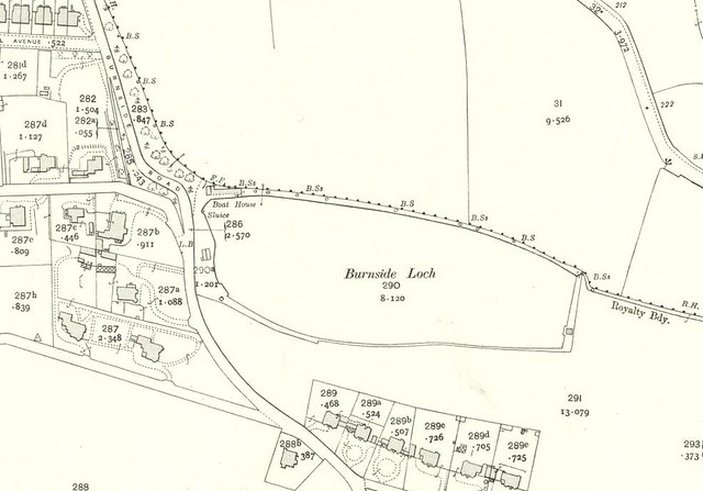
Vinegar Tom wrote:...finally tracked down the location of Burnside Loch. Nowhere near where I thought it was - the former boating pond is now football pitches...

I knew where the site of Burnside Loch was but I didn't know it had been used as a boating pond.

I'm certain I've seen other old maps that show the loch went dry in summer, which would suggest it was more akin to a marsh than a loch. If that's the case, it's surprising that it could support boating activities. I'm guessing that man-made changes were necessary to enable boating though, as the map extract you posted shows a sluice where the burn left the loch at its western end (I'm sure there was no indication of a sluice on the other old maps) - that indicates the depth of water in the loch was being controlled and the obvious supposition would be that the reason for doing so was to artificially raise the water level.

You may be interested to know that the burn still exists, though almost wholly (if not completely) in culverted form. It flows in a general westerly direction before joining with another other burn from slightly further south (i.e. the one that runs along the southern boundary of 42 Burnside Road) just before Fernhill Road. There is (or at least was, in recent years) a very short (no more than a couple of metres) open section in the rear garden of one of the properties on the north side of Crawfurd Gardens.

Quite a few burns/culverts can be found in that area (e.g. the Whitlaw Burn). The Scion Burn is one that I have an interest in at the moment - its source is located somewhere in the general vicinity of the eastern end of Blairbeth Road. It is completely culverted all the way down to the Clyde, with the exception of a very short (about 1 metre) open section behind 10 Glenlui Avenue. A few years ago, I managed to trace it as far upstream as an access chamber at the entrance to Blairbeth Terrace. Over recent months, Scottish Water and South Lanarkshire Council have jointly been CCTV surveying most of the stretch of the burn culvert from Blairtum Drive to the former Richmond Laundry site and have uncovered one or two interesting things, such as large uncharted culverts that join it (including one big enough to walk up if you crouch!).

Re: Old Maps.co.uk - Want to see more detail??

PostPosted: Mon Feb 20, 2012 12:03 pm
by cell
Just noticed they have also added the 7th series 1952-1961 of the 1" OS maps as well, hopfully they will continue to add and we will get some more post war high resolution OS maps.

This link lets you flick between different map series which some people might find useful.

http://geo.nls.uk/search/#zoom=9&lat=56.22741&lon=-3.37839&layers=B00000FFFFFFFTT

Re: Old Maps.co.uk - Want to see more detail??

PostPosted: Mon Feb 20, 2012 5:51 pm
by Icecube
Just be careful with dates printed on 25inch O.S. maps.
e.g. one I have just looked at has '1860' emblazoned across the top while at the bottom a more correct date of 1877 is printed. I say more correct because the one I looked at had features on it that were built well after 1860. Furthermore the NLS used the following information:
survey date 1858 (which was the original survey)
publication date 1864 (which may have been the first publication of the original survey)

The date given along the bottom beside "Zincongraphed and Published at the Ordance Survey Office, Southampton" will refer accurately to the revision (update) of the original survey that you are looking at on the screen and not the confusion referred to by the NLS which can only refer to the original.

Re: Old Maps.co.uk - Want to see more detail??

PostPosted: Thu Apr 25, 2013 1:10 pm
by Sharon
Past Maps, has had an update (thanks nodrog!), it works pretty smoothly. http://pastmap.org.uk/

Re: Old Maps.co.uk - Want to see more detail??

PostPosted: Sat Jun 22, 2013 1:38 pm
by cell
As Sharon says Pastmap has been greatly improved and well worth a visit
http://pastmap.org.uk/
Zoom into the map down to OS scale and select the “listed buildings” layer from the right, this brings up all the listed buildings in that area which can be clicked on to bring up the Historic Scotland record. If you select the Canmore layer you can click through to the RCAHMS record. Using either can bring up good info on any old buildings or sites that you come across during a wander.

Re: Old Maps.co.uk - Want to see more detail??

PostPosted: Sat Jun 22, 2013 8:01 pm
by HollowHorn
Yikes! Another two hours gone. :)

Re: Old Maps.co.uk - Want to see more detail??

PostPosted: Sun Jun 23, 2013 11:33 am
by Vinegar Tom
Aye, that is brilliant. A real time sucker.