Stop me if I'm wrong, is not this new
"Shields Rd Depot"
at St. Andrews Drive in Pollokshields not
running about four months behind schedule?
Cyclo-paths
My Youngsters are getting more confident
on their bikes, we're hoping to trundle down
some Paisley routes before summer's done.
The Hidden Glasgow Forums
To post in the forums you will need to first register. All new members are welcomed, with one caveat: You must behave and be nice AND SEARCH BEFORE POSTING!
The Glasgow, Paisley & Ardrossan Canal
Moderators: John, Sharon, Fossil, Lucky Poet, crusty_bint, Jazza, dazza
48 posts
• Page 3 of 4 • 1, 2, 3, 4
Re: The Glasgow, Paisley & Ardrossan Canal
![]() by MungoDundas » Tue Jun 15, 2010 9:51 pm
by MungoDundas » Tue Jun 15, 2010 9:51 pm
- MungoDundas
- Second Stripe

- Posts: 346
- Joined: Wed Jun 15, 2005 10:35 pm
Re: The Glasgow, Paisley & Ardrossan Canal
![]() by spaceshuttle » Wed Aug 18, 2010 5:03 pm
by spaceshuttle » Wed Aug 18, 2010 5:03 pm
You might like to consider re-opening the canal in theese days of high uneployment in Paisley and Johnstone I can think of nothing more inviting than a sail down the old canal in a wooden horse drawn barge. Finishing the journey the yougsters so deeply wanted to make.
By doing so with traditional building methods it would create much needed jobs and make Paisley a credit to Scotland leading the way in travel and tourism. Not to mention bring some hope and solice to those involved in later disasters.
By doing so with traditional building methods it would create much needed jobs and make Paisley a credit to Scotland leading the way in travel and tourism. Not to mention bring some hope and solice to those involved in later disasters.
Life is a moment in time to be enjoyed
- spaceshuttle
- Just settling in

- Posts: 9
- Joined: Tue Jun 15, 2010 1:11 pm
- Location: Johnstone
Re: The Glasgow, Paisley & Ardrossan Canal
![]() by Icecube » Sat Aug 21, 2010 9:12 pm
by Icecube » Sat Aug 21, 2010 9:12 pm
Thats a touching post and we hope you enjoy your next orbit.
- Icecube
- Second Stripe
- Posts: 371
- Joined: Sun Jun 21, 2009 1:22 pm
Re: The Glasgow, Paisley & Ardrossan Canal
![]() by Lucky Poet » Sat Aug 21, 2010 9:56 pm
by Lucky Poet » Sat Aug 21, 2010 9:56 pm
Ach, I've heard worse ideas.
All the world seems in tune on a Spring afternoon, when we're poisoning pigeons in the park.
-

Lucky Poet - -

- Posts: 4161
- Joined: Sat Jun 30, 2007 1:15 am
- Location: Up a close
Re: The Glasgow, Paisley & Ardrossan Canal
![]() by HollowHorn » Sat Aug 21, 2010 11:02 pm
by HollowHorn » Sat Aug 21, 2010 11:02 pm
I kwite liked it.
-

HollowHorn - Third Stripe

- Posts: 8921
- Joined: Mon May 23, 2005 9:59 pm
- Location: Paisley
Re: The Glasgow, Paisley & Ardrossan Canal
![]() by spaceshuttle » Mon Sep 06, 2010 1:05 pm
by spaceshuttle » Mon Sep 06, 2010 1:05 pm
Thankyou, the orbit I will enjoy most is the first one when virgin space brings space travel down to the price of Mr average and Mrs modest and I can gape at the canal from the moon. In the mean time a friend suggested that all it takes is a petition with enough signitures on it handed to the local MPs of the concerned constiuate boundries the Canal passed through. I see the Paisley to Johnstone line as an act of love I'm sure someone somewhere would be interested in a film about it. Lets face when the Lairds anounced they were hiring men to dig out a canal on which they planned to sail a boat the locals probably thought it was hilarious I know I was born and bred in Elderslie. I believe that anything is possible I have to My mum was the third person in Scotland to have open heart surgery they stuck her in a bath of cold water to stop her heart and a machine invented by Charles lindberg the first pilot to fly the Atlantic single handed kept her alive. So it is not intirele impossible in my humble opinion that the Canal could be rebuilt. I will never qualify as a navvy but lets face it there are far worse youth oppertunity projects going around this area at least the Canal would bring some much needed tourism into the town.
Life is a moment in time to be enjoyed
- spaceshuttle
- Just settling in
- Posts: 9
- Joined: Tue Jun 15, 2010 1:11 pm
- Location: Johnstone
Re: The Glasgow, Paisley & Ardrossan Canal
![]() by Cashbackboy » Tue Feb 01, 2011 2:37 pm
by Cashbackboy » Tue Feb 01, 2011 2:37 pm
Hi all
Not been here for a wee while, and came across this thread by accident. I've got some pictures of the site of the canal basin in Johnstone if anyone is interested, took them a couple of years ago.
http://www.travelandmixpix2.fpic.co.uk/c1652268.html
Cheers,
Graham
Not been here for a wee while, and came across this thread by accident. I've got some pictures of the site of the canal basin in Johnstone if anyone is interested, took them a couple of years ago.
http://www.travelandmixpix2.fpic.co.uk/c1652268.html
Cheers,
Graham
It took God six days to make the Earth, on the seventh day he made Andy Ritchie!
-

Cashbackboy - Busy bunny

- Posts: 12
- Joined: Fri Jun 02, 2006 6:50 am
- Location: Johnstone, Scotland
Re: The Glasgow, Paisley & Ardrossan Canal
![]() by HollowHorn » Tue Feb 01, 2011 8:41 pm
by HollowHorn » Tue Feb 01, 2011 8:41 pm
Great stuff, Graham, the Gordon plaque is quite a surprise! 
-
HollowHorn - Third Stripe
- Posts: 8921
- Joined: Mon May 23, 2005 9:59 pm
- Location: Paisley
Re: The Glasgow, Paisley & Ardrossan Canal
![]() by HollowHorn » Sun May 29, 2011 12:15 pm
by HollowHorn » Sun May 29, 2011 12:15 pm
Peter Burnet, or Black Peter as he was called in the district, was an American Negro, and an acquaintance of one of Tannahill's brothers. The relations of the poet ever afterwards showed him many attentions.
See the original pamphlet on Peter Burnet in Sharon's post below:
viewtopic.php?f=15&t=11249
-
HollowHorn - Third Stripe
- Posts: 8921
- Joined: Mon May 23, 2005 9:59 pm
- Location: Paisley
Paisley Canal Street Disaster
![]() by Gerrycalder » Fri Jun 22, 2012 10:37 am
by Gerrycalder » Fri Jun 22, 2012 10:37 am
Greeting,My great great grand father was awarded a gold medal for his heroics saving lifes at this disaster.
His name was James Denning and the medal was inscribed to him on the back reflecting the above.
I can find no records about this award ,but must have been a recorded event locally and possibly paid through the public purse.
Can anyone help?
Unfortunatley the medal was left as security with Major David Watts (for Car repair and petrol and overnight accomodation) at his home in Melton Mobray wilst trying to return to Paisley on a trip to London with Gerry Rafferty and Joe Egan trying to secure a record contract in 1966.
I have been unable to obtain its return since,but would like to confirm its provenance and possible picture for my families history
I do hope that you can help.
Regards
Gerry Calder
- Gerrycalder
- Just settling in
- Posts: 1
- Joined: Wed Jun 20, 2012 11:50 pm
Re: Paisley Canal Street Disaster
![]() by Godsgift » Fri Jun 22, 2012 5:49 pm
by Godsgift » Fri Jun 22, 2012 5:49 pm
Good grief. I was just reading about this last night and it goes back over 200 years. It was a Canal disaster where many drowned when a barge overturned, not a canal street disaster. I wouldn't know where you'd find info on the medal though. Good luck in your search though.
-

Godsgift - Second Stripe
- Posts: 146
- Joined: Wed Jan 25, 2012 10:52 pm
- Location: Co. Clare. West of Ireland
Re: The Glasgow, Paisley & Ardrossan Canal
![]() by Anorak » Mon Jan 13, 2014 11:44 am
by Anorak » Mon Jan 13, 2014 11:44 am
Took Josef's advice to revisit this thread after mentioning Glasgow's canal network elsewhere.
Josef mentioned that before the advent of the railways the Glasgow, Paisley & Johnstone Canal had
Rivers and canals certainly were the preferred mode of short distance passenger transport in the decades immediately before the introduction of the railways.

The canal passage boats offered a relatively fast, frequent service.
As well as the final destinations of Paisley and Johnstone, some of the boats met up with a horse-drawn omnibus to connect with Barrhead.
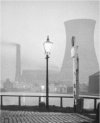
I've lifted this picture from my http://www.scotcities.com/railways/cumberlandst.htm web page showing the terminus of the Paisley Canal at Port Eglinton as it is now. Was investigating the station and the old rail lines at the time, rather than the canal.
The photograph was taken from the Eglinton Street flyover of the M74 extension when I managed to get a walk along the the elevated section before it was opened for road traffic. Unfortunately no future HG contributors will ever get the opportunity to share this view without getting either killed or (preferably) arrested!

The picture shows the overgrown site of the former canal and rail terminus at Port Eglinton alongside the railway line heading towards St Enoch Station. The remains of the platforms of Cumberland Street Station on the other side of Eglinton Street can be seen in the distance. You can also get a glimpse of the red sandstone station entrance at Salisbury Street.
Here is an old map showing the canal terminus on the edge of Eglinton Street before the railway came along. Cumberland Street runs west to east at the top of the map.

An aerial view of Port Eglinton before the start of the M74 construction when the trees on my photo were mere saplings!
The railway line to Central Station is running right to left, following the route of Eglinton Street towards the town. The line to St Enoch Station is running bottom to top, following the path of Cumberland Street.

I would have been on the flyover with my camera at the very bottom, middle, of the picture (marked with the red star).
Josef mentioned that before the advent of the railways the Glasgow, Paisley & Johnstone Canal had
for quite some time substantially cut the journey time from Paisley to Glasgow from somewhere in the region of hours to 45 minutes.
Rivers and canals certainly were the preferred mode of short distance passenger transport in the decades immediately before the introduction of the railways.
The canal passage boats offered a relatively fast, frequent service.
As well as the final destinations of Paisley and Johnstone, some of the boats met up with a horse-drawn omnibus to connect with Barrhead.
I've lifted this picture from my http://www.scotcities.com/railways/cumberlandst.htm web page showing the terminus of the Paisley Canal at Port Eglinton as it is now. Was investigating the station and the old rail lines at the time, rather than the canal.
The photograph was taken from the Eglinton Street flyover of the M74 extension when I managed to get a walk along the the elevated section before it was opened for road traffic. Unfortunately no future HG contributors will ever get the opportunity to share this view without getting either killed or (preferably) arrested!
The picture shows the overgrown site of the former canal and rail terminus at Port Eglinton alongside the railway line heading towards St Enoch Station. The remains of the platforms of Cumberland Street Station on the other side of Eglinton Street can be seen in the distance. You can also get a glimpse of the red sandstone station entrance at Salisbury Street.
Here is an old map showing the canal terminus on the edge of Eglinton Street before the railway came along. Cumberland Street runs west to east at the top of the map.
An aerial view of Port Eglinton before the start of the M74 construction when the trees on my photo were mere saplings!
The railway line to Central Station is running right to left, following the route of Eglinton Street towards the town. The line to St Enoch Station is running bottom to top, following the path of Cumberland Street.
I would have been on the flyover with my camera at the very bottom, middle, of the picture (marked with the red star).
- Anorak
- Second Stripe
- Posts: 163
- Joined: Tue Nov 20, 2007 12:19 am
Re: The Glasgow, Paisley & Ardrossan Canal
![]() by Alycidon » Mon Jan 13, 2014 12:53 pm
by Alycidon » Mon Jan 13, 2014 12:53 pm
Someone correct me if I am wrong, but I think that the location in the bottom photograph was once the only place in Scotland where a four track railway line crossed a four track railway line.
[img]http://www.jhowie.force9.co.uk/emu314carcream.gif[/img]
We must perform a Quirkafleeg!!!!
We must perform a Quirkafleeg!!!!
-
Alycidon - Third Stripe
- Posts: 1047
- Joined: Mon Apr 18, 2005 11:11 am
- Location: Eaglesham
Re: The Glasgow, Paisley & Ardrossan Canal
![]() by sjclancy » Thu Mar 13, 2014 4:38 pm
by sjclancy » Thu Mar 13, 2014 4:38 pm
I've just been looking back throught this thread and thought some of you might be interest in a walk I'm doing this Saturday for the RWH1697 Heritage & Creative Hub - Paisley Canal and the Ferguslie Thread Mills. Walk will start in the Hub in the Paisley Centre and head out to the Old Canal St Station for a journey along the line of the Canal to the Old Halftime School, then into the Mill Complex.
Full details are up on http://www.whatsonrenfrewshire.co.uk/event/007149-rwh1697-walking-tour:-paisley-canal-&-ferguslie-mill/ Starts at 11am, for up to 2hrs. Cost £4
Full details are up on http://www.whatsonrenfrewshire.co.uk/event/007149-rwh1697-walking-tour:-paisley-canal-&-ferguslie-mill/ Starts at 11am, for up to 2hrs. Cost £4
-

sjclancy - Busy bunny
- Posts: 31
- Joined: Sun Sep 23, 2007 8:01 pm
- Location: Paisley
Re: The Glasgow, Paisley & Ardrossan Canal
![]() by HollowHorn » Thu Mar 13, 2014 6:26 pm
by HollowHorn » Thu Mar 13, 2014 6:26 pm
Sorry, SJ, I'm w**king. 
Yes Bridie, you do.
-
HollowHorn - Third Stripe
- Posts: 8921
- Joined: Mon May 23, 2005 9:59 pm
- Location: Paisley
48 posts
• Page 3 of 4 • 1, 2, 3, 4
Return to Hidden Glasgow Projects
Who is online
Users browsing this forum: Google [Bot] and 23 guests