Page 4 of 28

PostPosted: Tue Jun 15, 2004 12:26 am
by crusty_bint
Great maps Birdie! When did the Buchannan Street tunnel closed?

Crusty

PostPosted: Tue Jun 15, 2004 1:12 am
by birdie
not 100% sure, although will probably have been in the 1960-1962 period with the Beeching cuts. sorry for the spelling mistake on the maps, it should say Kelvinside, not Kelivinside.

Birdie.

PostPosted: Tue Jun 15, 2004 1:00 pm
by birdie
These are a few pics of some tunnels around Glasgow from my last visit.

Mosesfield North and South portals

Image

Image


Looking towards the South portal of Crow Road

Image


Balgray South portal under a restuarant. Tunnel is very dry throughout and a good covering of ballast.

Image


Tamshill North portal. This is probably underneath foundations for a house now, as it was ready to be filled in on my visit. Ruchill tunnel had already been filled in when this picture was taken.

Image


Provan Gasworks North portal. When this picture was taken, the tunnel was inaccessible, due to about 6 feet of water at the mouth. Visited the tunnel 3 months later and all the water has disappeared...wierd.

Image

Birdie

PostPosted: Tue Jun 15, 2004 1:30 pm
by birdie
To help answer caine's question, this is a zoomed in map of Bridgeton, showing where the offices are. There is a gate to the car park there, which is often shut at the weekends. The gate to the tunnels was padlocked a while ago, but was open in Feb 2004.

Image

Birdie.

PostPosted: Tue Jun 15, 2004 1:53 pm
by james73
Where are the Mosesfield and Tamshill tunnels? And I take it the Balgray
South portal is the one under the restuarant on Great Western Road, the
former Kelvinside station? That image shows, presumably, the platform
and track area.


James H

PostPosted: Tue Jun 15, 2004 2:00 pm
by james73
james73 wrote:Where are the Mosesfield and Tamshill tunnels? And I take it the Balgray
South portal is the one under the restuarant on Great Western Road, the
former Kelvinside station? That image shows, presumably, the platform
and track area.


James H


Just seen the maps on the previous page :oops:


James H

PostPosted: Tue Jun 15, 2004 2:16 pm
by james73
crusty_bint wrote:Great maps Birdie! When did the Buchannan Street tunnel closed?

Crusty


The station was closed November 1966. The south tunnel portal is still
visible, although is now hidden behind new flats. The area of the north
portal in Pinkston Road was 'landscaped' in the early 1980's and only a
small round brick building with a door gives the location away.

http://www.hiddenglasgow.com/rail/BuchananTunnel.htm


James H

PostPosted: Tue Jun 15, 2004 2:21 pm
by birdie
Kelvinside is wierdly listed as the tunnel under the present day Hyndland station, which is not really anywhere near Kelvinside estate. No idea where the name Balgray came from either, not sure if it's the name of any street nearby. These were the names of the tunnels according the 1962 sectional appendix, which someone had passed on to me.

Birdie

PostPosted: Wed Jun 16, 2004 12:57 am
by Pgcc93
Former Kelvinside Station in the mid 1970's now Stazione Bar/Restraunt.

Note the partially demolished stairwell's. The stair rods and treads have been removed to prevent access as the station was situated in a deep cutting. You can just about make out the undulations on the trackbed where the rails have been lifted.

Image

The name Balgray refers to the land on which the course of the railway ran through/under. There was a farm or dwelling called South Balgray circa 1860's close to where Kelvinside Station was built.

PostPosted: Wed Jun 16, 2004 10:46 am
by james73
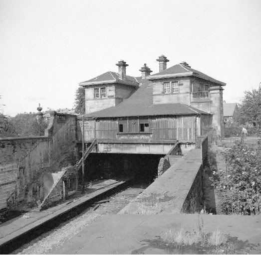
Pgcc93 wrote:Former Kelvinside Station in the mid 1970's now Stazione Bar/Restraunt.

Note the partially demolished stairwell's. The stair rods and treads have been removed to prevent access as the station was situated in a deep cutting. You can just about make out the undulations on the trackbed where the rails have been lifted.

Image

The name Balgray refers to the land on which the course of the railway ran through/under. There was a farm or dwelling called South Balgray circa 1860's close to where Kelvinside Station was built.


Great picture. Looks suspiciously like the staircases were covered wooden
affairs, judging by the indentations in the retaining walls.


James H

PostPosted: Wed Jun 16, 2004 10:56 pm
by birdie
Thanks for the info on Balgray. After I seen the reply, I remember looking on oldmaps.co.uk a while back and noticed Balgray on there.

Cheers for that

Birdie

PostPosted: Wed Jun 16, 2004 11:43 pm
by birdie
This is an extract from an 1865 map from oldmaps.co.uk. It shows how Balgray tunnel got it's name.
You may notice that the Royal Lunatic Isylum is now more commonly known as Gartnavel Hospital.

Birdie.

Image

PostPosted: Wed Jun 16, 2004 11:56 pm
by Pgcc93
your estimation of the tunnel looks pretty accurate going by the old maps.

PostPosted: Thu Jun 17, 2004 12:07 am
by birdie
Just to add a bit more, this is the north (or East to be exact) portal of Balgray. It's right at the end of a new cul-de-sac and unfortunately I don't have the name of it. The picture's a bit blurred, because it was chucking it down at the time.

Birdie.

Image

PostPosted: Thu Jun 17, 2004 12:18 am
by Pgcc93
It emerges at Balcarres Avenue in Kelvindale formerly known as West Balgray then onward to Maryhill to the North and the GCR via Botanic Gardens Station etc.