tunnels

Moderators: John, Sharon, Fossil, Lucky Poet, crusty_bint, Jazza, dazza

Re: tunnels

Postby Pgcc93 » Sun Mar 02, 2008 6:01 pm

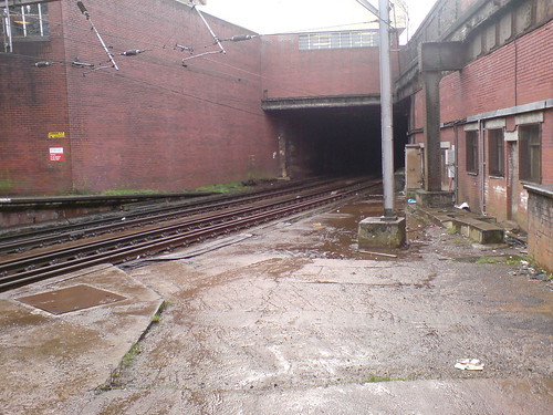
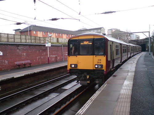
Timchilli wrote:Looking at the video, I'm assuming this is Glasgow Cross?

Is the light flooding in from the streetlevel cover?

Tim


That's the very spot TC, I wonder if it'll ever reopen one day if Crossrail ever goes ahead
User avatar
Pgcc93
Third Stripe
Third Stripe
 
Posts: 4104
Joined: Thu Jul 24, 2003 8:12 pm
Location: Hotel Du Vin

Re: tunnels

Postby dougie79 » Mon Mar 03, 2008 1:08 pm

Have been meaning to visit the old London Road station for ages, so I took advantage of having a weekend off and went a wander, took some pics so I hope you like them.

Image

After a nice climb down we got to the old platform

Image

Looking towards the parkhead tunnel

Image

Pretty bad flooding wasnt getting to walk through there today.

Image

Hope they do reopen this line.

Image

Looking towards the current bridgeton station.

Image

Further investigation required, the bridgeton tunnel split has been bricked up.

Image

Bridgeton station with the london road line connecting behind the right hand wall.

Image

Remains of old flooring.

Image
More of that flooring

Image

Looking over from Bridgeton station.

Image

Our train home.

Image

One last word of advice ::):
Underground Overground wandering free
User avatar
dougie79
Second Stripe
Second Stripe
 
Posts: 251
Joined: Mon May 07, 2007 8:43 pm
Location: Linthouse

Re: tunnels

Postby Return of UUU » Sun Mar 16, 2008 1:20 am

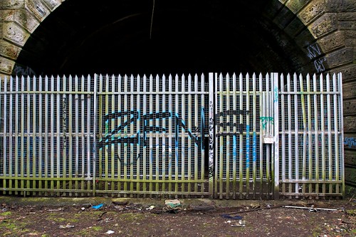
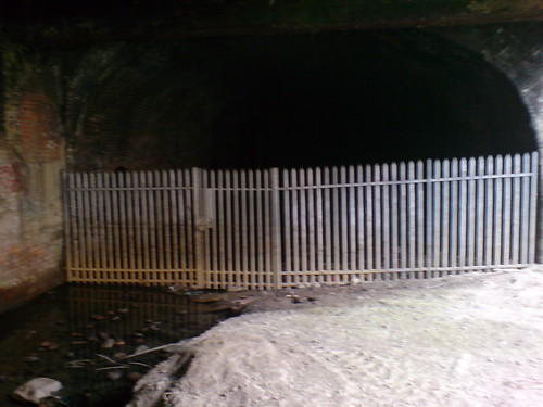
scotgio wrote:I found this site the other day, and having seen the images of the botanics station was very interested in visiting, as well as the tunnel entrance under Gibson Street.

I went out today, and much to my dismay the fence appears to be in pretty good shape!
I couldn't get in the Kirklee entrance, this is what I found:

Image


I was there today (showing my sons the old lines) and it has acquired razor wire along the top of the fence. I thought it seemed new and shiny, but that means it is "2 week old new and shiny"!

AKH
Return of UUU
Busy bunny
Busy bunny
 
Posts: 13
Joined: Mon Apr 18, 2005 9:15 pm
Location: Glasgow

Re: tunnels

Postby harki » Sat May 03, 2008 9:32 pm

see below
Last edited by harki on Sat May 03, 2008 9:35 pm, edited 1 time in total.
Colin H
harki
Just settling in
Just settling in
 
Posts: 8
Joined: Fri Apr 13, 2007 8:20 am

Re:

Postby harki » Sat May 03, 2008 9:34 pm

birdie wrote:These are some map scans of Glasgow showing some disused tunnels in the area. They may be helpful in your explorations.

Birdie

Image

Image


Regarding the tunnel at Chapel Street on the map page 3.... the southern portal behind the Gala Bingo is filled in!
Colin H
harki
Just settling in
Just settling in
 
Posts: 8
Joined: Fri Apr 13, 2007 8:20 am

Re: tunnels

Postby BenCooper » Fri Dec 26, 2008 11:54 pm

So, I went to Bridgeston Station today for a wee look around - the platform is pretty much the same:

Image

The tunnel is flooded, but it's not too deep:

Image

Further along, the remains of car that got surprisingly far into the tunnel:

Image

I also went along the Bridgeton Central branch line - there's a bunch more pictures in my Flickr set...
www.transientplaces.co.uk
BenCooper
Second Stripe
Second Stripe
 
Posts: 183
Joined: Mon May 26, 2008 4:06 pm

Re: tunnels

Postby engineer » Tue Dec 30, 2008 11:08 pm

just missed out on a walk along the london road tunnel, might manage it next year.
apparently plans are afoot to refurbish it.
User avatar
engineer
Third Stripe
Third Stripe
 
Posts: 790
Joined: Fri Apr 08, 2005 9:33 pm
Location: media quarter

Re: tunnels

Postby glasgowken » Wed Dec 31, 2008 1:38 am

Nice photos all, it's quite bizarre to see that car there 8O
GK
User avatar
glasgowken
Third Stripe
Third Stripe
 
Posts: 4477
Joined: Mon Oct 03, 2005 12:59 am
Location: Glasgow

Re: tunnels

Postby fullfatmilk » Thu Mar 12, 2009 9:32 pm

Hi folks

I took a couple of pictures of the dis-used railway tunnel just off the Gallowgate the other day.

This is the link on google maps:

http://maps.google.co.uk/maps?f=q&source=s_q&hl=en&geocode=&q=&ie=UTF8&ll=55.856055,-4.232376&spn=0.001493,0.006845&t=h&z=18

I notice that it's been completely cleared off the trees that previously grew in it but i don't know how long ago that was?

Image

Image
fullfatmilk
Busy bunny
Busy bunny
 
Posts: 30
Joined: Mon Jan 28, 2008 10:33 pm
Location: Glasgow

Re: tunnels (apology)

Postby fullfatmilk » Thu Mar 12, 2009 11:57 pm

Previous image posting error resolved! (sorry)
fullfatmilk
Busy bunny
Busy bunny
 
Posts: 30
Joined: Mon Jan 28, 2008 10:33 pm
Location: Glasgow

Re: tunnels

Postby rotten milk » Fri Mar 13, 2009 12:13 am

remember seeing summat on RAILSCOT:

http://www.railbrit.co.uk/location.php? ... %20Central

not sure it's exactly the same bit, but near enough - talking 2 yrs ago

i take it the single tunnel looks towards bridgeton, the two tunnels head for (left) the union line roundabout college goods, (right) the dive-under that joined up at high st.

EDIT: found the link for your bit:

http://www.railbrit.co.uk/location.php? ... 20Junction
hey, d'ye think it's ootside yir in?
rotten milk
Second Stripe
Second Stripe
 
Posts: 107
Joined: Sat Feb 07, 2009 12:32 am
Location: the far east

Re: tunnels

Postby fullfatmilk » Fri Mar 13, 2009 12:37 am

thanks for the links to the images :)

the single tunnel entrance passes under the Gallowgate, through the north of the Calton, under Abercromby Street and is visible again behind the Health Centre, beside Kerr Street.

http://maps.google.com/?ie=UTF8&ll=55.852848,-4.227397&spn=0.003939,0.009613&t=h&z=17

It's then underground again, (previously) connecting with Bridgeton Train Station where Dalmarnock Road and London Road almost meet.
fullfatmilk
Busy bunny
Busy bunny
 
Posts: 30
Joined: Mon Jan 28, 2008 10:33 pm
Location: Glasgow

Re: tunnels

Postby fullfatmilk » Fri Mar 13, 2009 12:47 am

Rotten,

there was a link on the site you listed to station at 'Parkhead Stadium'

http://www.railbrit.co.uk/imageenlarge/imagecomplete.php?id=13490

i can't place it, do you (or anyone) know if it's visible via google maps?

EDIT:

s'ok - think i find found it?
http://maps.google.com/?ie=UTF8&ll=55.848205,-4.202925&spn=0.003939,0.009613&t=h&z=17

Always had some notion that it was on the south side of London Road @ Celtic Park somewhere?

Also found out this info to:
"PARKHEAD Railway station served the east end of Glasgow for much of the last century. Opening in 1897 it was renamed Parkhead Stadium in 1952 because of its proximity to Celtic's ground. The station was situated in a cutting overlooked by what is now called Whitby Street but which was then known as Winston Street in honour of Winston Churchill who had married a neice of Lord Newlands who was a well known benefactor in the area. Newlands primary school at Parkhead Cross was built by him and bequeathed to the people of the area in perpetuity. In July 1914 King George V, Queen Mary and their entourage disembarked here for a royal visit to Beardmore's Parkhead Works. It was a victim of Beeching's rail reform and closed in late 1964. In 1989 it was filled in and landscaped. In the background can be seen the floodlights of Celtic park which were first switched on in Oct 1959 and at the time were reputed to be the highest in the world standing at 208 feet above the pitch. The photo was taken in June 1963."


Image
fullfatmilk
Busy bunny
Busy bunny
 
Posts: 30
Joined: Mon Jan 28, 2008 10:33 pm
Location: Glasgow

Re: tunnels

Postby rotten milk » Fri Mar 13, 2009 1:22 am

i think 'parkhead stadium' refers to the tunnel mouth
(centre of pic here)
http://maps.google.co.uk/maps?ie=UTF8&l ... 8&t=h&z=17

there was a 'parkhead' station, to the right, in front of 'W whitby st.', see the clump o' trees? zoom out and you can follow the(former) line of the Glasgow central railway from carmyle and tollcross

diagram : http://www.railbrit.co.uk/Glasgow_Centr ... /frame.htm (parkhead station is called parkhead south)

this line ran under london road and joined the (present) line that ran under dalmarnock road, at bridgeton cross. this is the line that runs into glasgow central low level

incidentally on your first pics, if you went under gallowgate (and sydney street) the first open bit was the site of gallowgate central.

EDIT - just seen your reply - i was fannying about posting my reply! ::):
hey, d'ye think it's ootside yir in?
rotten milk
Second Stripe
Second Stripe
 
Posts: 107
Joined: Sat Feb 07, 2009 12:32 am
Location: the far east

Re:

Postby Charlie Endell » Sat Apr 25, 2009 6:53 pm

BTJustice wrote:On the subject of Cathcart station and the kiosk, I posted these in the past present thread a while ago;

Image

Image

What was the purpose of this part of the station (I take it the doorway leads up to what is now the roof of Beechings)? My flat looks out across the railway onto the roof of Beechings, hence my curiousity. I hadn't even noticed that there used to be a second bridge at Cathcart until I saw the old photograph.
User avatar
Charlie Endell
First Stripe
First Stripe
 
Posts: 66
Joined: Sat Nov 01, 2008 3:27 pm
Location: Cathcart (exiled from Soho)

PreviousNext

Return to Hidden Glasgow Projects

Who is online

Users browsing this forum: No registered users and 22 guests