
Posted:
Thu Feb 16, 2006 11:01 pmby james73
Thanks for them. Any more?
James H
Posted:
Fri Feb 17, 2006 6:47 amby McShad
Trossachs and Lomond motorway..... that would be such a travesty
Posted:
Fri Feb 17, 2006 11:45 amby motman
I remember 'A Highway Plan for Glasgow' in the 60s and borrowing it from a uni library in Oakfield Avenue when I was at Hillhead. We made models of the Kingston Bridge and the cutting at Charing X as part of a school project. (fiddly matchsticks to represent the bridge columns and all that).
It is truly frightening that most of the contents of that book are still achievable today - although I suspect that the projected traffic volumes may need a wee tweaking upwards

There just has to be some mad planner somewhere siting there rubbing his hands just waiting to be let loose when the 21st century's equivelant of CDAs are announced.

Re: Glasgow Highway Plans - c1965
Posted:
Fri Feb 17, 2006 1:27 pmby Toaster
Fascinating to see this stuff in such detail - previously I'd only seen general maps of the planned motorway network. It's hard to imagine the Hamilton Expressway going right past the People's Palace, Aikenhead Road as a motorway, a big tunnel under Queen's Park...
Posted:
Mon Feb 20, 2006 4:49 pmby Alasdair
The funny thing is that a lot of it DID happen.
Many of the blue lines on the map (except for Great Western Road) show where a motorway now is. Many of the red lines on the map indicate where an expressway now is (Clydeside, Springburn, East Kilbride, Cumbernauld). The difference is that the planners daren't call them 'motorways' because they don't have hard shoulders, but they're still heavy-polluting roads that cut through communities.
Most of the other lines on the map (e.g. the 'Kilmarnock Expressway', Maryhill Road, Great Western Road, old A8) are now 'urban free ways' where cars aren't allowed to park. With a few big exceptions near the city centre, thank goodness, and in East Dunbartonshire, where the planners didn't really get their way at all.
I don't know, but although they used the terms 'motorway', 'expressway' and 'bypass' too freely, most of what was in these plans has now been achieved. It's a shame, but even now there are probably some scary maps in existence which plan to tear up the city and green belt with more roads.
Posted:
Mon Feb 20, 2006 11:21 pmby scallopboy
I'm guessing in the 1960's the road planners never accounted for traffic 2 adults working and the kids living at home with cars because they can't afford to move out and all working in different directions. I guess they may have though by the 21st Century we'd all be wearing silver suits and taking our helicopters to work.
Posted:
Sun Mar 12, 2006 8:58 pmby HollowHorn
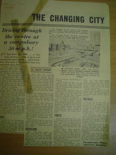
Found this on Flicker, save & magnify for an interesting wee read.
Posted:
Mon Mar 13, 2006 1:49 pmby AMcD
Posted:
Mon Mar 13, 2006 2:22 pmby swavmcav
What on earth is the "decked insustrial" area that is to be "the most compact" in the world.
It seems to indicate that construction was well under way at the time of writing.
Any idea?
Posted:
Mon Mar 13, 2006 4:58 pmby AMcD
The Skypark site at Finnieston?
Posted:
Mon Mar 13, 2006 11:11 pmby red_kola
I think that was designed as retail and housing though. It became more office space after it
failed as a shopping centre but was never industrial. I'd go with the Skypark (or whatever it used to be called) too.
Posted:
Tue Mar 14, 2006 2:46 amby crusty_bint
No, AMCD is right in suggesting that it was Skypark hinted at in the article, and Gordon is right in suggesting thqt its in Anderston: not Finnieston.
 :
: