Bombs over Glasgow in WW2

Moderators: John, Sharon, Fossil, Lucky Poet, crusty_bint, Jazza, dazza

Postby Socceroo » Tue Jan 03, 2006 6:50 pm

A wee bit off topic, but still to do with Glasgow during the War :

Winston Churchill shakes the hand of Mr Thompson of Sandyhills on 17th January 1941, during his visit of the Glasgow area.

Image

Glasgow, was particularly in the latter part of the war, in part due to it's geography, seen as an excellent centre for the rest and relaxation of allied troops.

Below is a photo of troops washing and shaving upon arrival in Glasgow at the well appointed washrooms in Central Station. (1944)

Image

Also available in Central Station at that time was the Barber's Shop, where you could get a shave or a haircut. (1944)

Image
User avatar
Socceroo
Third Stripe
Third Stripe
 
Posts: 1369
Joined: Thu Sep 08, 2005 8:51 pm
Location: Mount Flo, Glasgow

Postby retired tiger » Sun Jan 08, 2006 8:44 pm

Socceroo wrote:GLASGOW PREPARES FOR WAR
Here is one of Glasgow's war time precautions which i came across but was not previously aware of. The picture below shows the Bomb damage precautions which were put in place of the Forth and Clyde Canal. Photograph's below were taken at the Firhill Basin.

To the left is essentially a sheet pile Dam to narrow the width of the Canal to be closed in an emergency. Between the Concrete blocks an emergency Lock gate could be placed to dam the Canal if it was bombed where it sits higher than areas of the city and could cause substantial flooding if bombed.

Image

These Emergency Lock gate positions / Canal narrowings were, as you can see from the picture below (circa late 1960's), in place for some time after the war.

I do not know if there is remnants of these fixtures still in place at Firhill Basin and at Speirs Wharf which were two of the locations, or if they were removed during the Canal refurbishment around the millenium.

Image


Been out for a walk along the canal today, passed the items pictured at Firhill Basin, they're all there almost exactly as shown. Speirs Wharf towpath is fence off for repairs to the canal side stone work.
User avatar
retired tiger
Second Stripe
Second Stripe
 
Posts: 314
Joined: Wed Jul 27, 2005 11:26 pm
Location: beside the judges

Postby gwendle » Mon Jan 09, 2006 7:33 pm

The_Clincher wrote:I've heard accounts of Kilmun St in Maryhill being decimated during WW2 with the sky being "black" with Luftwaffe planes.

Maybe some on here will be able to give you more info....i will gather anecdotal evidence in due course and post my findings on here. :)


Hello people. Just new here and thought I would help with this one. My gran was a child at the time and told me she lived in Cumlodden Drive and the bomb was heading directly for their house on its wee parachute, but luckily for her a freak gust blew it down towards Kilmun Street where it hit the school.
User avatar
gwendle
First Stripe
First Stripe
 
Posts: 76
Joined: Mon Jan 09, 2006 7:05 pm

BOMBS OVER GLASGOW

Postby Socceroo » Fri Jan 13, 2006 10:05 am

Some help would appreciated here guys.

I have now with the help from HG forum..mers, various books, The Mitchell and the Imperial War Museum got about 60 - 70 major bomb sites in Glasgow that can be fairly accurately plotted on a map.

Question is what is the best map to use? I was thinking along the lines of an OS Landrager type map of about 1:25,000 scale or it's Crown Office predecessor, better still a 1:50,000 series. Obviously it would need to be Glasgow and it should really be between the period 1940 - 1960, i don't think the city changed too much between these dates.

I am thinking that maps from the period 1940 - 45 might be a bit scarce.

Anyone got any info where i can buy a paper copy or buy a online version which could be downloaded?

Cheers Socceroo :)
User avatar
Socceroo
Third Stripe
Third Stripe
 
Posts: 1369
Joined: Thu Sep 08, 2005 8:51 pm
Location: Mount Flo, Glasgow

Re: BOMBS OVER GLASGOW

Postby My Kitten » Fri Jan 13, 2006 12:32 pm

Socceroo wrote:I am thinking that maps from the period 1940 - 45 might be a bit scarce.

Anyone got any info where i can buy a paper copy or buy a online version which could be downloaded?

Cheers Socceroo :)


I'm having the same problem with the clydebank bombings :(
User avatar
My Kitten
Third Stripe
Third Stripe
 
Posts: 6105
Joined: Sun Feb 15, 2004 10:10 am

Postby AlanM » Fri Jan 13, 2006 12:37 pm

I assume you've already tried http://www.alangodfreymaps.co.uk
Who needs a six pack....when you've got a keg!!!
Image
User avatar
AlanM
Third Stripe
Third Stripe
 
Posts: 1827
Joined: Wed Sep 07, 2005 8:59 am
Location: Knightswood

Postby Sir Roger DeLodgerley » Fri Jan 13, 2006 1:37 pm

User avatar
Sir Roger DeLodgerley
Third Stripe
Third Stripe
 
Posts: 423
Joined: Fri Oct 08, 2004 10:05 am
Location: Bedside Manor, Wilts.

Postby My Kitten » Fri Jan 13, 2006 1:56 pm

What I'm really looking for is a downloadable map that I can highlight the streets. Stumped!
User avatar
My Kitten
Third Stripe
Third Stripe
 
Posts: 6105
Joined: Sun Feb 15, 2004 10:10 am

Postby Apollo » Fri Jan 13, 2006 3:43 pm

If you mean you want a downloadable map that you can pan and zoom in the same way you do with the likes of maps. google or similar, then you're wasting your time if you just want something to do a bit of Glasgow in the same way.

These, and their non-online partners such as the maps that come with GPS or products like Route66 build their display on the fly, like html displaying in browser, and need the whole application to function.

I've done this for some projects, and all I did was either use the mapping application to save a jpg (or other suitable graphic, as I prefer to work with a lossless format and save only the final version in a lossy format) of the area required (which may mean pasting more than one depending on the required resolution) or use a screen grab to obtain the required area.

Once you've got the graphic, you can add layers or edit it to show the roads and locations of interest.
User avatar
Apollo
Third Stripe
Third Stripe
 
Posts: 2283
Joined: Sun May 09, 2004 10:26 pm
Location: Glasgow

Postby Apollo » Fri Jan 13, 2006 4:33 pm

Her's an alternate offering that might be of interest.

Geobloggers is currently off-line, but supposedly due to return in a few days, or I'd have given you an example here. For anyone that didn't try it, Geobloggers allowed you to host pics in Flickr, and pin them on to a Google map, so visitors could see where an item was sited, and open the link to see the image.

No point in me describing more, the detail may be different when it returns, but you can imagine how this could be used to group together and display pics from a project (create a user account for each project).

The creator's been snapped up by Yahoo, but reckons he'll continue to run Google maps and Microsoft too, so users can have a choice of what suits their local area best as he's aware some of them don't favour Europe.
User avatar
Apollo
Third Stripe
Third Stripe
 
Posts: 2283
Joined: Sun May 09, 2004 10:26 pm
Location: Glasgow

Postby Socceroo » Sat Jan 14, 2006 12:34 pm

Thanks for all the Map suggestions folks, i remember seeing http://www.old-maps.co.uk myself a while ago as suggested by Roger DeLodgerley. Their site's down for maintenance just now but should be back up soon.

Crusty's pointed me towards a particular map that they do which fits what i'm looking for.

I like the idea that Appllo was suggesting about the possibility of an online Project Map such as geobloggers or similar where various individuals on the HG Community could contribute to a project. Sounds cool, we'll need to keep an eye on that one.

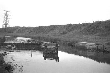
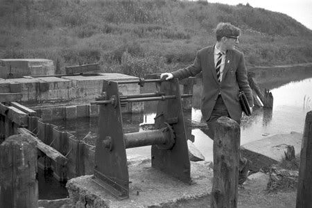
Thanks also to Retired Tiger for confirming that the Emergency Lock Gate Piers are still in place at Firhill Basin.

Image

I think these are the Piers as seen on Google Earth.

I contacted the Imperial War Museum about four weeks ago via e-mail, they have been excellent, they are all for getting the information out there "lest we forget" i suppose.

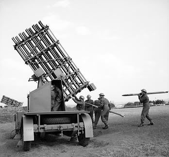
Anyway, whilst looking at the Bombings etc i have came across quite a lot of info on Glasgow's war time defences. A surprising amount of Ack Ack guns and rockets ringed Glasgow following the 1941 raid's on Clydeside.

They came too late to act as a deterrent for the March 1941 raids but the rockets in particular were placed in "prominent sites to let the Luftwaffe know they were there".

I have got a fairly detailed list of sites of the Aircraft defences in and around Glasgow now. I am waiting on more specific Grid References to map out. Who knows perhaps there will be some more remnants worth visiting other than the well documented ones such as Mugdock?
User avatar
Socceroo
Third Stripe
Third Stripe
 
Posts: 1369
Joined: Thu Sep 08, 2005 8:51 pm
Location: Mount Flo, Glasgow

Postby escotregen » Sun Jan 15, 2006 2:27 pm

Socceroo was your reference to anti-aircraft rockets (rather than guns) just incidental or have you some info on these in the first part of WW2? I have now and again read of some vague references to rockets, but these seem to have been highly experimental... or the ones that became common after 1942 (i.e. 'Stalin Organs' etc.)
escotregen
Third Stripe
Third Stripe
 
Posts: 1073
Joined: Tue Jan 13, 2004 3:35 pm
Location: glasgow

Postby Socceroo » Sun Jan 15, 2006 2:55 pm

Image

Escoty, here is a photograph of a "Z" Rocket Battery. They were two sites in Glasgow at Aitkenhead Road and at Balornock which later moved to Blackhill.

They were not experimental as such. They were actually credited with shooting down an enemy aircraft over the city, which would have meant that they would have been operational by March 1943, which is the date given to the last recorded Luftwaffe Air Raid over Glasgow.

However, some of the research i have been doing is coming up with conflicting information with regards to which Anti Aircraft Companies were in the city at various times during the war.

I have got some other photo's that i'll post later showing the UP or "Z" Batteries as they became known in action. They were pretty fearsome weapons.
User avatar
Socceroo
Third Stripe
Third Stripe
 
Posts: 1369
Joined: Thu Sep 08, 2005 8:51 pm
Location: Mount Flo, Glasgow

Postby retired tiger » Sun Jan 15, 2006 3:05 pm

Image

Apolgies for size of pic, just experementing with photobucket, seems better than flicker for not making pics too wee. Anyway for those that don't know the above is where the Glasgow branch of the Forth and Clyde Canal is being re-joined to Port Dundas. Can't wait to see a Puffer back in the Port.
User avatar
retired tiger
Second Stripe
Second Stripe
 
Posts: 314
Joined: Wed Jul 27, 2005 11:26 pm
Location: beside the judges

Postby escotregen » Sun Jan 15, 2006 4:04 pm

Socceroo thanks for that info, very revealing. As you say, these fearsome things were clearly more than just experimental.
escotregen
Third Stripe
Third Stripe
 
Posts: 1073
Joined: Tue Jan 13, 2004 3:35 pm
Location: glasgow

PreviousNext

Return to Hidden Glasgow Projects

Who is online

Users browsing this forum: No registered users and 26 guests