The Hidden Glasgow Forums
To post in the forums you will need to first register. All new members are welcomed, with one caveat: You must behave and be nice AND SEARCH BEFORE POSTING!
The Approach To Glasgow Central Station 1960
Moderators: John, Sharon, Fossil, Lucky Poet, crusty_bint, Jazza, dazza
30 posts
• Page 2 of 2 • 1, 2
Approaches to Glasgow Central 1960
![]() by Duchess » Tue Jul 05, 2005 11:36 am
by Duchess » Tue Jul 05, 2005 11:36 am
Great pic but are you sure it/s 1960? I seem to remember the new signalling was in place by that time and the old bridge and signalbox closed although the framework existed for many years after.
- Duchess
- Just settling in

- Posts: 2
- Joined: Mon Jul 04, 2005 3:44 am
- Location: Glasgow
![]() by Alycidon » Tue Jul 05, 2005 4:03 pm
by Alycidon » Tue Jul 05, 2005 4:03 pm
According to Ewan Crawford's site the new signalling was comissioned on the 2nd of January 1961 and going by the new ballast and ground signals in position I would say that the preparatory work was well underway when the picture was taken so 1960 would be perfectly correct. The bridge was not dismantled until 1966 as shown by the pictures available on the RCAHMS site
http://www.rcahms.gov.uk/scotland_screenres_800/669043.jpg
http://www.rcahms.gov.uk/scotland_screenres_800/669043.jpg
-
Alycidon - Third Stripe

- Posts: 1047
- Joined: Mon Apr 18, 2005 11:11 am
- Location: Eaglesham
The approach to Glasgow Central - 1894
![]() by Alycidon » Thu Jul 07, 2005 8:52 pm
by Alycidon » Thu Jul 07, 2005 8:52 pm
Here is how it was before the new bridge was built.

-
Alycidon - Third Stripe
- Posts: 1047
- Joined: Mon Apr 18, 2005 11:11 am
- Location: Eaglesham


![]() by Schiehallion » Sat Jul 09, 2005 1:10 pm
by Schiehallion » Sat Jul 09, 2005 1:10 pm
The map is from the 1892-4 ordnance survey. Have a look at the 1857-8 map and you'll see Alston Street and the buildings that were there before Glasgow Central was built.
http://www.nls.uk/digitallibrary/map/ea ... ml#glasgow
http://www.nls.uk/digitallibrary/map/ea ... ml#glasgow
-
Schiehallion - Third Stripe
- Posts: 1625
- Joined: Sat Mar 20, 2004 9:32 pm
What else to like.
![]() by Dexter St. Clair » Sat Jul 09, 2005 4:53 pm
by Dexter St. Clair » Sat Jul 09, 2005 4:53 pm
I like the way it shows the pubs. McSorley's , The Vintners, what's the one next to it on Clyde Street. And the one on Wood lane. I take it that is the Argyll Bar under the Bridge.
-
Dexter St. Clair - Third Stripe
- Posts: 6252
- Joined: Tue Nov 16, 2004 9:54 pm
![]() by Schiehallion » Sat Jul 09, 2005 5:26 pm
by Schiehallion » Sat Jul 09, 2005 5:26 pm
You'll notice in Alycidon's 1892 map the west side extension (up at platforms 9, 10, 11, 12 & 13) hasn't yet been built and there's a church where the carriage drive now is. The platforms are numbered the other way round and that would need to change when the station was extended.
Also the original roof stopped short at Argyle St and the Heilanman's Umbrella would've been an open bridge. The end of platform stairs (which are still there today) took you down and out the station into Argyle St under the bridge.
In this picture, the original glass roof which stopped short of Argyle St can easily be seen as the ridges run north/south.
-
Schiehallion - Third Stripe
- Posts: 1625
- Joined: Sat Mar 20, 2004 9:32 pm


![]() by Schiehallion » Sat Jul 09, 2005 9:06 pm
by Schiehallion » Sat Jul 09, 2005 9:06 pm
gap74 wrote:Small pic, but the original bridge over Argyle St can be seen in this pic - the only pic of it I think I've ever come across where it's open.
Gary
Nice one Gary - I've never seen the bridge like that before!
-
Schiehallion - Third Stripe
- Posts: 1625
- Joined: Sat Mar 20, 2004 9:32 pm
![]() by crusty_bint » Sat Jul 09, 2005 10:28 pm
by crusty_bint » Sat Jul 09, 2005 10:28 pm
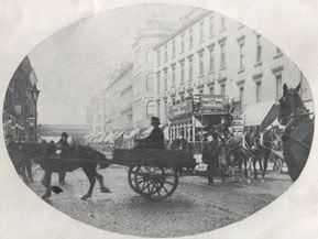
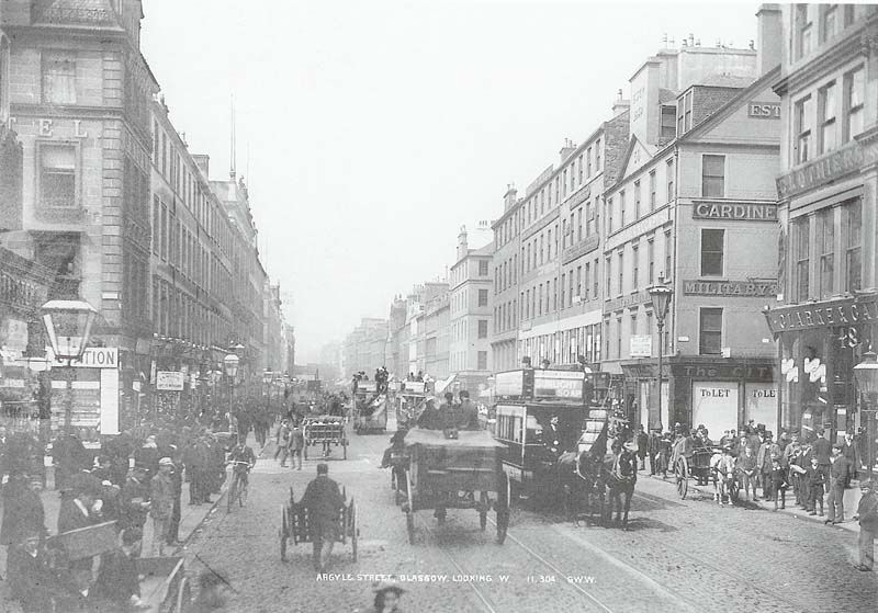
Heres a larger pic, unfortunately the bridge is just a smidge more distant: c.1880 (Miller St on the right, Debenhams on the left)
- crusty_bint
- -

- Posts: 4425
- Joined: Thu Jan 29, 2004 3:52 pm
- Location: Glasgow


![]() by crusty_bint » Sun Jul 10, 2005 12:48 am
by crusty_bint » Sun Jul 10, 2005 12:48 am
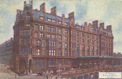
Cracker innit  I'd imagine the station it refers to would have been St Enoch Station which was just behind it
Anyone care to do a present shot?
Anyone care to do a present shot?
- crusty_bint
- -
- Posts: 4425
- Joined: Thu Jan 29, 2004 3:52 pm
- Location: Glasgow


30 posts
• Page 2 of 2 • 1, 2
Return to Hidden Glasgow Projects
Who is online
Users browsing this forum: No registered users and 41 guests