Page 1 of 2
Queen St Station Quarry

Posted:
Fri Apr 08, 2005 10:50 amby Seamey
My history lecture stated that the space where Queen Street station is was once a quarry - yes I know another one. The shape does look plausible - anyone know any details?
Posted:
Fri Apr 08, 2005 11:10 amby Sir Roger DeLodgerley
Yup, that agrees with what I read about the origins of Queen Street station. Unfortunately the book I read it in is at home and I'm at work. I'll dig it out and post details later.
Posted:
Fri Apr 08, 2005 6:07 pmby Sir Roger DeLodgerley
What a twat. I got home only to find that the book in question was in the office all along. Gollocks.


Sorry about being such a fanny. I did find the following in the history of Glasgow's Railways:
"Queen Street station was a pitifully cramped affair cowering in an old sandstone quarry below Dundas Street."
Posted:
Fri Apr 08, 2005 6:34 pmby dazza
There were three major quarries in the Queen Street station area: Cracklinghouse, Provanside and Ewings. Cracklinghouse was in operation between the early 1700's - 1790 (approx.) whereafter it was filled in to make way for Buchanan Street. Provanside, which probably existed from medieval times, was filled in around 1840. James Ewing sold his quarried ground to Edinburgh & Glasgow Railway in 1837, which then became Queen St Station.
Posted:
Sun Apr 10, 2005 2:58 pmby Schiehallion
Posted:
Mon Apr 11, 2005 9:34 amby kokotheclown
Does that mean that the low level at Queen St isnae really a tunnel?
Is the high level actually built on top like the second floor of a building?
Posted:
Mon Apr 11, 2005 5:40 pmby james73
kokotheclown wrote:Does that mean that the low level at Queen St isnae really a tunnel?
Is the high level actually built on top like the second floor of a building?
Thats exactly what it's like. The low level is at ground level and the high
level is built on top of it.
James H
Posted:
Mon Apr 11, 2005 8:46 pmby johnnyanglia
I was told that the stone from the quarry was used to build Glasgow Cathedral
Re: Queen St Station Quarry
Posted:
Mon Mar 04, 2013 9:44 pmby HollowHorn
Found this sketch of the five quarries, I've not seen it before:
(You may have to shoogle up the page an inch or two)
http://books.google.co.uk/books?id=F2gp ... CE0Q6AEwBQ
Re: Queen St Station Quarry
Posted:
Mon Mar 04, 2013 11:48 pmby Guacho
Good find

Re: Queen St Station Quarry
Posted:
Tue Mar 05, 2013 4:50 pmby cell
This 1832 map might be of interest, it shows the quarries and "proposed street" which threw me for a bit.
http://maps.nls.uk/towns/reform/view/?id=2592#zoom=5&lat=18972&lon=22556&layers=BT
Re: Queen St Station Quarry
Posted:
Thu Jun 27, 2013 1:42 pmby k_stewa
Hi everyone,
I've been trying to find an answer to this question for ages! I was wondering what Queen Street Station was beforehand as there appears to be two doorways on North Hanover Street (see images attached). It's really interesting to discover it used to be a quarry but if anyone can shed some light as to where these doors may have lead to, I would very much appreciate it.
Many thanks,
Kim
door_exterior_web.jpg
door_interior_web.jpg
Re: Queen St Station Quarry
Posted:
Thu Jun 27, 2013 1:57 pmby Mori
Could be the Grain Store.


also some info here on the quarry
The Glasgow Story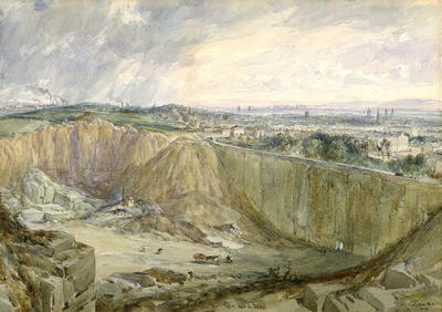
Re: Queen St Station Quarry
Posted:
Thu Jun 27, 2013 3:36 pmby k_stewa
Wow, thanks Mori! That sounds about right. Where did you get those first two images? I'm looking to use this information in a short film and would like to include them.
Thanks again,
Kim
Re: Queen St Station Quarry
Posted:
Thu Jun 27, 2013 6:08 pmby Mori
k_stewa wrote:Wow, thanks Mori! That sounds about right. Where did you get those first two images? I'm looking to use this information in a short film and would like to include them.
Thanks again,
Kim
Hi Kim
The map you can aquire from
http://maps.nls.uk/geo/explore/ and the image you can get from
rcahmsHope this helps.