The Hidden Glasgow Forums
To post in the forums you will need to first register. All new members are welcomed, with one caveat: You must behave and be nice AND SEARCH BEFORE POSTING!
A Street Under Argyle Street
Moderators: John, Sharon, Fossil, Lucky Poet, crusty_bint, Jazza, dazza
Re: The street under Central Station?
![]() by conor lingus » Wed Nov 05, 2008 2:28 pm
by conor lingus » Wed Nov 05, 2008 2:28 pm
- conor lingus
- Just settling in

- Posts: 6
- Joined: Fri Oct 31, 2008 11:18 am
- Location: Yoker
Re: The street under Central Station?
![]() by Dexter St. Clair » Wed Nov 05, 2008 7:43 pm
by Dexter St. Clair » Wed Nov 05, 2008 7:43 pm
-
Dexter St. Clair - Third Stripe

- Posts: 6252
- Joined: Tue Nov 16, 2004 9:54 pm
Re: The street under Central Station?
![]() by dazza » Wed Nov 05, 2008 11:36 pm
by dazza » Wed Nov 05, 2008 11:36 pm
I included that link in my reply, darling.
-

dazza - -

- Posts: 1933
- Joined: Sun Dec 07, 2003 4:25 pm
Re: The street under Central Station?
![]() by Mori » Wed Nov 05, 2008 11:37 pm
by Mori » Wed Nov 05, 2008 11:37 pm
Glasgow's Forgotten Village

-

Mori - Third Stripe
- Posts: 3434
- Joined: Wed May 04, 2005 1:05 pm
- Location: Glasgow
Re: The street under Central Station?
![]() by Anorak » Thu Nov 06, 2008 10:51 am
by Anorak » Thu Nov 06, 2008 10:51 am
There was no village demolished to make way for Central Station.
Grahamston had been razed a long time before the 1870’s.
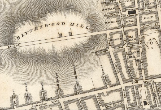
Here’s a map from 1783 showing Grahamston.

It appears as a small settlement to the west of the expanding city of Glasgow.
Buchanan Street is the only recognisable city centre street in the vicinity.
By the 1850’s, some 20 years before the development of Central Station, the situation is much different.

By this time Grahamston had long gone, been replaced by the city centre blocks bounded by Argyle Street, Hope Street, Gordon Street and Union Street.
You can even see the street under Central Station, Alston Street!
By the 1890’s the last part of the former site of Grahamston was ready for redevelopment for the expansion of Central Station.

I prepared this map for entirely different thread, showing the development of Glasgow Railway Termini.
It shows the buildings soon to be demolished for the station extension.
Looks like typical Victorian block to me with the street layout of the surviving buildings being much the same as they were in the 1850’s map.
The maps clearly show that the little village of Grahamston was not demolished to make way for Central Station, there was in fact a City Centre street on the site.
I wouldn’t rely on any of the information from the Grahamston Story publication to answer the original query
- Anorak
- Second Stripe

- Posts: 163
- Joined: Tue Nov 20, 2007 12:19 am
Re: The street under Central Station?
![]() by Ronnie » Thu Nov 06, 2008 5:36 pm
by Ronnie » Thu Nov 06, 2008 5:36 pm
Anorak wrote:I wouldn’t rely on any of the information from the Grahamston Story publication to answer the original query
OK, which of the sources of the book are questionable, which of the conclusions are unsupported, and which historical sources are you using to condemn the book?
-

Ronnie - Third Stripe
- Posts: 1983
- Joined: Sat Jan 17, 2004 11:22 pm
- Location: Glasgow
Re: The street under Central Station?
![]() by Anorak » Thu Nov 06, 2008 7:51 pm
by Anorak » Thu Nov 06, 2008 7:51 pm
That would have shut me up and left me satisfied that I was wrong!
I would have regarded any subsequent development in the area as urban encroachment, rather than the village expanding to take in office blocks, warehouses and pubs. Which dictionary did you use for your definition of “village”?
Photographs of the buildings being demolished in the 1870’s to make way for the construction of the station tell us absolutely nothing about the old Grahamston village.
The contemporary maps, backed up by old Post Office Directories and Valuation Rolls will show exactly what was demolished in the affected streets while Central Station was being developed.
I’m always willing to be proved wrong, it happens regularly.
Here is a quote from the Grahamston Story website:
“The area taken up by the station covered the eastern and middle portions of the Grahamston site but the western side of the village, including St Columba’s Church, remained intact until the turn of the century, when the remainder of the village was demolished to make way for a station extension.”
Have a look at the 1890’s map of the area referred to in the quote. Where exactly is “the remainder of the village” ?
- Anorak
- Second Stripe
- Posts: 163
- Joined: Tue Nov 20, 2007 12:19 am
Re: The street under Central Station?
![]() by Mori » Thu Nov 06, 2008 8:52 pm
by Mori » Thu Nov 06, 2008 8:52 pm
Chronicles of Grahamston or something along that line.
-
Mori - Third Stripe
- Posts: 3434
- Joined: Wed May 04, 2005 1:05 pm
- Location: Glasgow
Re: The street under Central Station?
![]() by Lucky Poet » Thu Nov 06, 2008 9:13 pm
by Lucky Poet » Thu Nov 06, 2008 9:13 pm
(It came from <here>.)
While the blank spaces don't necessarily mean there was nothing there, it suggests the area was a building site, or about to be one. It's curious that Hope Street isn't shown though, only a vague line...
-

Lucky Poet - -
- Posts: 4161
- Joined: Sat Jun 30, 2007 1:15 am
- Location: Up a close
Re: A Street Under Argyle Street
![]() by Anorak » Fri Nov 07, 2008 10:03 am
by Anorak » Fri Nov 07, 2008 10:03 am
The whole premise of the Grahamston Story is very doubtful to say the least.
Does anyone really believe that a city centre village existing at the end of the 18th century was still in place at the end of the 19th century when the demolition squads moved in to make way for Central Station?
It’s easier to believe in streets under Argyle Street, Santa Claus and the Tooth Fairy!!
- Anorak
- Second Stripe
- Posts: 163
- Joined: Tue Nov 20, 2007 12:19 am
Re: A Street Under Argyle Street
![]() by Anorak » Fri Nov 07, 2008 1:10 pm
by Anorak » Fri Nov 07, 2008 1:10 pm
Are we to believe that the development of the city streets is rather different around Union Street and Alston Street because it is part of Ronnie’s “urban village” and the rest is just Glasgow city centre?
Looks very much like the development of the city centre, a small part of which was on the site of a flattened old settlement once known as Grahamston.
If I was to a walk along Gordon Street from Borders bookshop to Central station with my 1850’s map, I’d be leaving Glasgow behind and entering some mythical village?
- Anorak
- Second Stripe
- Posts: 163
- Joined: Tue Nov 20, 2007 12:19 am
Re: A Street Under Argyle Street
![]() by Lucky Poet » Fri Nov 07, 2008 10:26 pm
by Lucky Poet » Fri Nov 07, 2008 10:26 pm
In the interests of balance, or to be a dick depending on your point of view, according to the 1783 map Grahamston lay along an already-defined Argyle Street, and what looks like field boundaries ran off to the north at similar angles to the later street layout; so do many of the indicated buildings. It doesn't say what these buildings were like - they might have been thatched cottages for all I know, but if they were more substantial it could well be that much of the older settlement was absorbed into the city as it moved west, rather than obliterated, with the individual buildings replaced later on as wealth grew and tastes changed. Calling it a village is maybe a bit of artistic license?
-
Lucky Poet - -
- Posts: 4161
- Joined: Sat Jun 30, 2007 1:15 am
- Location: Up a close
Re: A Street Under Argyle Street
![]() by Anorak » Sat Nov 08, 2008 9:23 am
by Anorak » Sat Nov 08, 2008 9:23 am
You are much too kind!
- Anorak
- Second Stripe
- Posts: 163
- Joined: Tue Nov 20, 2007 12:19 am
Re: A Street Under Argyle Street
![]() by Anorak » Sun Nov 09, 2008 1:11 am
by Anorak » Sun Nov 09, 2008 1:11 am
I was pleasantly shocked to find this quote in the Grahamston Story website:
“Mr Glasgow himself, the late Jack House, declared that the existence of Grahamston was 'a load of old cobblers'. Cobbles maybe, but not cobblers, as Gorbals-born author Norrie Gilliland has discovered in a painstakingly researched book about the village that time, and Glaswegians, forgot.'
Brian Swanson, The Daily Express
November 2002”
I think that, as would be expected, Jack got it right !!!!
- Anorak
- Second Stripe
- Posts: 163
- Joined: Tue Nov 20, 2007 12:19 am
Re: A Street Under Argyle Street
![]() by Mori » Sun Nov 09, 2008 2:31 pm
by Mori » Sun Nov 09, 2008 2:31 pm
-
Mori - Third Stripe
- Posts: 3434
- Joined: Wed May 04, 2005 1:05 pm
- Location: Glasgow
Return to Hidden Glasgow Projects
Who is online
Users browsing this forum: No registered users and 6 guests