I know the road dips... I agreed that it dipped... what I said was that the tunnel was on a higher level than the queen street on.
I have a large OS map of the area at my mums house... it should shed some further light on this.
I'm not entirely convinced they would infile that amount of area.
Oh, and I know what you mean about the smell... I was once told about a warehouse for soaps etc being burried under ground and that causes the smell
The Hidden Glasgow Forums
To post in the forums you will need to first register. All new members are welcomed, with one caveat: You must behave and be nice AND SEARCH BEFORE POSTING!
Buchanan Street Station (Not Subway)
Moderators: John, Sharon, Fossil, Lucky Poet, crusty_bint, Jazza, dazza
![]() by james73 » Thu Sep 22, 2005 10:47 am
by james73 » Thu Sep 22, 2005 10:47 am
McShad wrote:Oh, and I know what you mean about the smell... I was once told about a warehouse for soaps etc being burried under ground and that causes the smell
The area shown on the right hand side of this image is the suspected cause
of the rotten egg smell. It has been completely filled in. Behind the
train you can see the abutments of the bridge that carried a freight line over
the mainline, and behind that you can just make out the Pinkston Road bridge.

Is there a date for this pic BTW?
James H
- james73
- Third Stripe

- Posts: 2035
- Joined: Wed Dec 17, 2003 4:08 pm
- Location: urbanglasgow.co.uk - come & join us.....
![]() by Alycidon » Thu Sep 22, 2005 12:16 pm
by Alycidon » Thu Sep 22, 2005 12:16 pm
James
Will get the caption details from the book tonight. Meanwhile I have done an oldmaps/getmapping composite of the area, see below. The photograph would appear to have been taken from Fountainwell Drive, and the noxious pond would now appear to be the playing field
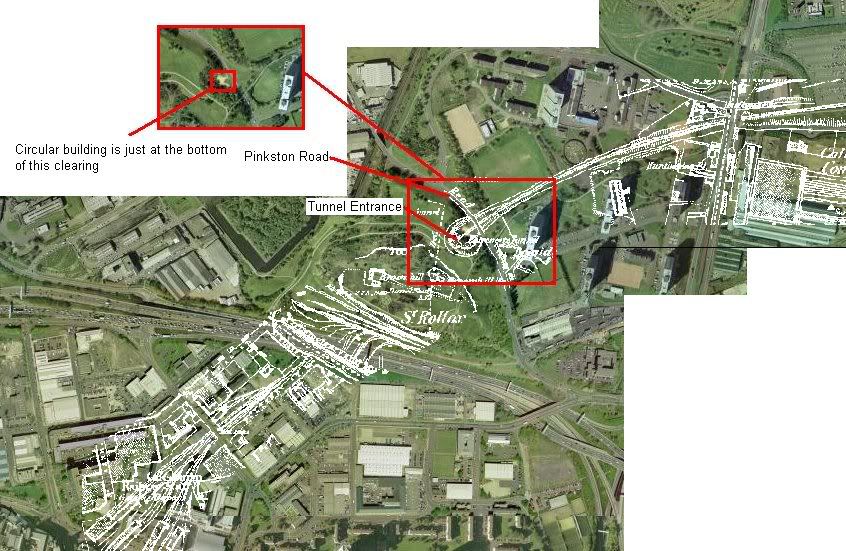
Will get the caption details from the book tonight. Meanwhile I have done an oldmaps/getmapping composite of the area, see below. The photograph would appear to have been taken from Fountainwell Drive, and the noxious pond would now appear to be the playing field
-
Alycidon - Third Stripe
- Posts: 1047
- Joined: Mon Apr 18, 2005 11:11 am
- Location: Eaglesham
![]() by McShad » Thu Sep 22, 2005 12:50 pm
by McShad » Thu Sep 22, 2005 12:50 pm
Excellent work man!
But something confuses me. With what I can make out as the old tunnel exit doesnt line up with what we suspect as the location of the exit now (That circle building)
You can make out where Fountainwell Road curves round and meets with Pinkston Road.... thats where out suspected Tunnel exit is
It's bloody confusing....
-

McShad - Third Stripe
- Posts: 1813
- Joined: Thu Sep 08, 2005 5:53 pm
- Location: Ibrox, Glasgow
![]() by Alycidon » Thu Sep 22, 2005 1:13 pm
by Alycidon » Thu Sep 22, 2005 1:13 pm
Have another look at the picture, I have annotated it with an inset showing the clearing without the old maps overlay. I think that this shows that the circular building is definately above the northern portal of the tunnel
-
Alycidon - Third Stripe
- Posts: 1047
- Joined: Mon Apr 18, 2005 11:11 am
- Location: Eaglesham
![]() by Alycidon » Thu Sep 22, 2005 2:03 pm
by Alycidon » Thu Sep 22, 2005 2:03 pm
More info, would also fit the Bombs over glasgow topic!!

The Railway line cuts across the middle of the photograph, with the tunnel mouth about half an inch from the LH edge and about two and a half inches from the top.
JBH
The Railway line cuts across the middle of the photograph, with the tunnel mouth about half an inch from the LH edge and about two and a half inches from the top.
JBH
-
Alycidon - Third Stripe
- Posts: 1047
- Joined: Mon Apr 18, 2005 11:11 am
- Location: Eaglesham
![]() by AlanM » Thu Sep 22, 2005 7:10 pm
by AlanM » Thu Sep 22, 2005 7:10 pm
Vladimir wrote:I still cant understand how the Germans were able to take these photos before the war. Did nobody find it kind of suspicious
Look at the text at the top right of the picture, this was taken during the war, April 1943.
Alan
-

AlanM - Third Stripe
- Posts: 1827
- Joined: Wed Sep 07, 2005 8:59 am
- Location: Knightswood

![]() by Alycidon » Thu Sep 22, 2005 7:44 pm
by Alycidon » Thu Sep 22, 2005 7:44 pm
Is there a date for this pic BTW?
James
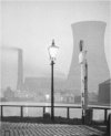
The Caption for the photo should have been "Class A4 Pacific no 60007 "Sir Nigel Gresley" leaves Glasgow Buchanan Street Tunnel with the northbound "St. Mungo" express for Aberdeen on August 29th 1964
-
Alycidon - Third Stripe
- Posts: 1047
- Joined: Mon Apr 18, 2005 11:11 am
- Location: Eaglesham
![]() by McShad » Thu Sep 22, 2005 8:57 pm
by McShad » Thu Sep 22, 2005 8:57 pm
ok, sorry... I retract previous statement as a brain cloud had overcome me... I just drove passed the area again.
I'm just back from spending a few hours at my mums house looking through the stuff we gathered in 1999 and the stuff on the internet.
The house we are interested in was 1 of 2 mansion houses on Parlie road... there only was 2 of them, originally built for the surgeon generals of the lunatic asylum, then bought by the railways for the station masters etc. Wickedly enough, the mitchell has got a picture of 328... we are after pictures and information on 336, its next door neighbour.
My mum has 2 pictures taken from North Fredrick street of 336... and a few years ago, the mitchell library really really really wanted a copy of them as they are very rare and much better quality of their picture of 328. I also shows the glorious gardens and the billboards which surrounded the front of the garden.
As for the location of where those houses stood, we did work it out. If it wasnt for the queen street tunnel airvent, we would never have worked it out. Doesnt help with killermont street being moved!!!
Number 328 lies under the extended North Hanover street (which used to climb further then dip back to Parlie road and terminate... now runs to Dobbies Loan)
As for 336... the top right corner of the bus station has a little building with toilet facilities and a waiting area for tour buses... thats where it stood. I have an accitate map of the area and a same scale modern map... line them up using the queen street tunnel and air vent as reference and it proves it.
I would scan the picture of 336 in, but my mum won't let me for various reasons... which I understand and will respect
-
McShad - Third Stripe
- Posts: 1813
- Joined: Thu Sep 08, 2005 5:53 pm
- Location: Ibrox, Glasgow
![]() by Alycidon » Fri Sep 23, 2005 11:26 am
by Alycidon » Fri Sep 23, 2005 11:26 am
Vladimir wrote:
I still cant understand how the Germans were able to take these photos before the war. Did nobody find it kind of suspicious
Alan Wrote
Look at the text at the top right of the picture, this was taken during the war, April 1943.
Aha! does it not seem strange that a Luftwaffe Map should have the date printed in English?? At the top left hand side of the map in German it says "Aufnahme vom 02.10.39" which roughly translates as the photogaphed date. I can only surmise that the 1943 date is when the map came into Allied hands, perhaps recovered from a bomber that was shot down.
-
Alycidon - Third Stripe
- Posts: 1047
- Joined: Mon Apr 18, 2005 11:11 am
- Location: Eaglesham
![]() by Pgcc93 » Thu Oct 27, 2005 10:07 pm
by Pgcc93 » Thu Oct 27, 2005 10:07 pm
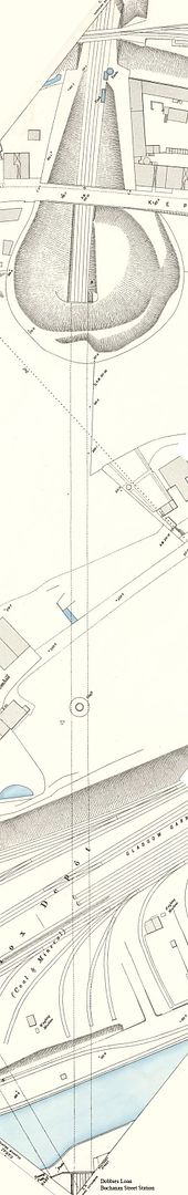
The tunnel in more detail.
Note the trig point beside the airshaft which would have been positioned on the highest point as seen in james73's pics earlier in the thread.
St.Rollox Railway Depot and the canal were situated above the southern tunnel entrance long since cleared to make way for the M8 motorway.
Just wish Google Earth would update the central Glasgow imagery as this would make an ideal overlay.
Last edited by Pgcc93 on Sat Mar 04, 2006 10:05 pm, edited 1 time in total.
-
Pgcc93 - Third Stripe
- Posts: 4104
- Joined: Thu Jul 24, 2003 8:12 pm
- Location: Hotel Du Vin
![]() by Alex Glass » Sat Mar 04, 2006 5:07 pm
by Alex Glass » Sat Mar 04, 2006 5:07 pm
partickular wrote:On the subject of that pub, I recall an isolated old spit'n'sawdust pub surrounded by ad-hoc car parks that existed on these sites around that time. I think it was called Bar 82, and always seemed to be popular howf. It remained in use until the mid 80s before the concert hall was built. Was this the same one as in the picture, or was it another? If you walked straight south from the new bus station, across the car parks where Parliamentary road was previously, heading straight down Dundas St heading for Queen St Stn, you'd pass it on your left. I was never in it (I was a teenager at the time), but it always looked a real old fashioned joint. Anyone else remember it?
Sorry to be behind the times with this post but thought it might interest some of you.
The Bar 82 is the pub in the photo although at the time of the photo being the mid 70's it was then called Matthew Reid's. The reason for the change in name I beleive was because it was 1982 when it finally had to provide facilities for women. Prior to the change in the licensing laws allowing later opening hours there was also a requirement for pubs to remove their male only status. This ensured that all pubs were open to everyone. Because of the size of Matt Reid's they claimed they had to refuse entry to women because the pub was too small. They did not have a lounge or the capacity to install a ladies toilet. Finally in 1982 the law was enforced and they had to construct a toilet at the back of the bar for ladies. If anyone has ever been in Matt Reid's I am sure you will agree there it was a tiny place.
My dad called this pub his local until it was demolished to make way for the Royal Concert Hall which as every one knows was completed in 1990.
It was a Man's Pub and they even had a notice on the front door "No Ladies"
-

Alex Glass - Third Stripe
- Posts: 2589
- Joined: Wed Jan 25, 2006 8:36 pm
- Location: Glasgow
Return to Hidden Glasgow Projects
Who is online
Users browsing this forum: No registered users and 72 guests