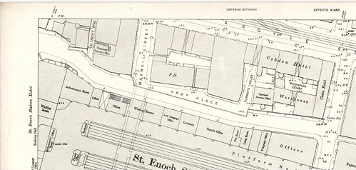
Rucola wrote:Knightmare wrote:I'm a bit confused. Can someone please clarify:- Did the trains arriving at St Enoch come in from the West ie under what is now the St Enoch Centre, or did they arrive from the south?
If you go and stand in the car park on the east side of Stockwell Street and compare it with the map above, you can still see quite clearly where the trains went — to the east over the arches that now house Mono cafe-bar and a t-shirt shop, and to the south up above the brick wall next to the Westering Winds pub. Where the bus stop now is on Stockwell St was underneath a bridge.
Rucola's post got me curious as I wasn't enirely sure what he meant, so I decided to check things out.
I've walked and parked in that area hundreds of times too but never really thought about why those bridges and viaducts were there and where it all went to.
Looking south towards the Westering Winds pub...

Then looking east from the same spot towards one of the bridges...

Under the same bridge looking north up King Street...

Other side of the same bridge looking south (towards the High Court/Clyde)...

This is the bridge which took the trains over the Clyde (viewed from the Albert bridge)...

Looking north from Saltmarket to bridge which took trains east...

Looking towards the same Saltmarket bridge from Osborne Street...

Junction of King St/Osborne St at T-Shirt Shop...

It all more or less makes sense if you look at the map.
Anything in the area that is now the King Street carpark is long gone as well as anything west of Stockwell Street.
All the other bits are still there. Wonder what it's like up on those bridges and viaducts?
From ground level it looks really overgrown. Look at those trees in the last picture!