Kerbstones
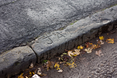
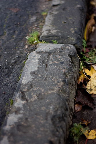
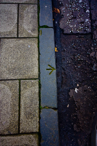
I've recently noticed that some older kerbstones round my way (West End) have letters carved into them - usually what looks like a T or a J, sometimes wee arrows. Does anyone know what these signify?
To post in the forums you will need to first register. All new members are welcomed, with one caveat: You must behave and be nice AND SEARCH BEFORE POSTING!
http://www.hiddenglasgow.com/forums/
http://www.hiddenglasgow.com/forums/viewtopic.php?f=15&t=10350
Shazbat wrote:I've recently noticed that some older kerbstones round my way (West End) have letters carved into them - usually what looks like a T or a J, sometimes wee arrows. Does anyone know what these signify?
Vinegar Tom wrote: I'm pretty sure they are marks made by the stonemasons who carved the kerbstones, to allow payment by piecework. Letters carved by those who could and symbols by those who couldn't read ??
Shazbat wrote:I've recently noticed that some older kerbstones round my way (West End) have letters carved into them - usually what looks like a T or a J, sometimes wee arrows. Does anyone know what these signify?
busdriver wrote:Shazbat wrote:I've recently noticed that some older kerbstones round my way (West End) have letters carved into them - usually what looks like a T or a J, sometimes wee arrows. Does anyone know what these signify?
These are bench marks used by Surveyors in conjunction with information from the Ordance Survey and are used as a reference to determine heights above mean sea level.
Further information from: http://tinyurl.com/3xpq84g
Vinegar Tom wrote: