The Hidden Glasgow Forums
To post in the forums you will need to first register. All new members are welcomed, with one caveat: You must behave and be nice AND SEARCH BEFORE POSTING!
Past Present
Moderators: John, Sharon, Fossil, Lucky Poet, crusty_bint, Jazza, dazza

![]() by JamesMc » Sat Apr 23, 2005 7:24 pm
by JamesMc » Sat Apr 23, 2005 7:24 pm
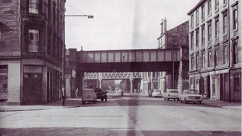
Cumberland st in the Gorbals, looking West 1965
2005

Difficult to get the proper angle as there is a wee wall and fence with shrubbery in the way, but you get the idea.
2005
Difficult to get the proper angle as there is a wee wall and fence with shrubbery in the way, but you get the idea.
I see dead buildings...
-

JamesMc - Second Stripe

- Posts: 286
- Joined: Sun Jul 11, 2004 3:41 pm
- Location: Glasgow
![]() by JamesMc » Sat Apr 23, 2005 7:30 pm
by JamesMc » Sat Apr 23, 2005 7:30 pm
A playpark in the Gorbals, early 1900's
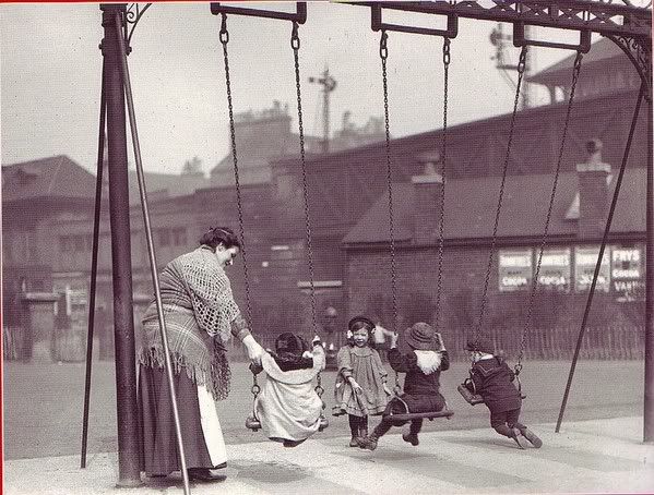
2005 - The railway bridge now defunct, the old station building now the Brazen Head pub. The swingpark a car park for a social club.\
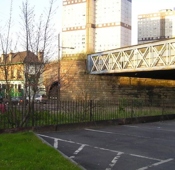
Both old pictures again from Eric Eunson's fantastic "The Gorbals - An Illustrated History"
2005 - The railway bridge now defunct, the old station building now the Brazen Head pub. The swingpark a car park for a social club.\
Both old pictures again from Eric Eunson's fantastic "The Gorbals - An Illustrated History"
I see dead buildings...
-
JamesMc - Second Stripe
- Posts: 286
- Joined: Sun Jul 11, 2004 3:41 pm
- Location: Glasgow
![]() by Schiehallion » Sat Apr 23, 2005 7:50 pm
by Schiehallion » Sat Apr 23, 2005 7:50 pm
JamesMc wrote:Cumberland st in the Gorbals, looking West 1965
2005
Difficult to get the proper angle as there is a wee wall and fence with shrubbery in the way, but you get the idea.
Is this the same scene? The corner of the pavement in the past pic is about 12 yards further from the bridge. Also the more distant bridge is supported by pillars in the old pic?
-
Schiehallion - Third Stripe

- Posts: 1625
- Joined: Sat Mar 20, 2004 9:32 pm
![]() by stinkpad » Sat Apr 23, 2005 8:04 pm
by stinkpad » Sat Apr 23, 2005 8:04 pm
Schiehallion wrote:Is this the same scene? The corner of the pavement in the past pic is about 12 yards further from the bridge. Also the more distant bridge is supported by pillars in the old pic?
Yes, the bridge in the background has been demolished - the one you can see in the today pic is obscured by the old one in the older pic.
-

stinkpad - Third Stripe
- Posts: 403
- Joined: Mon Jan 19, 2004 1:42 pm
- Location: Cathcart
![]() by lordsleek » Sat Apr 23, 2005 8:05 pm
by lordsleek » Sat Apr 23, 2005 8:05 pm
hope jamesmc doesnt mind me answering for him. the scene is the same but the road has been widened and the far away bridge has been replaced completely
Last edited by lordsleek on Sat Apr 23, 2005 8:07 pm, edited 1 time in total.
-

lordsleek - Third Stripe
- Posts: 477
- Joined: Tue Feb 15, 2005 11:43 am
- Location: Uddingston
![]() by JamesMc » Sat Apr 23, 2005 8:18 pm
by JamesMc » Sat Apr 23, 2005 8:18 pm
Yes, it is indeed the same scene. I can see where the confusion came from though, and thanks to stinkpad and lordsleek for clearing some of that up. As Lordsleek said, Hospital st at this point has has been widened and re-angled.Where the tenements on the left stood has been curtailed.
The bridge. I am a wee bit unclear on this one myself. It does look like a different bridge. The one there in the present does have pillar support on the far side, rusted so a bit hard to make out. The old bridge clearly has support on the nearest side.
Now stinkpad, do you think there were two separate bridges? Or has the bridge just been modified?
I see dead buildings...
-
JamesMc - Second Stripe
- Posts: 286
- Joined: Sun Jul 11, 2004 3:41 pm
- Location: Glasgow
![]() by JamesMc » Sat Apr 23, 2005 8:41 pm
by JamesMc » Sat Apr 23, 2005 8:41 pm
Lets see if this sheds any light. An aerial shot of the area from 1962.
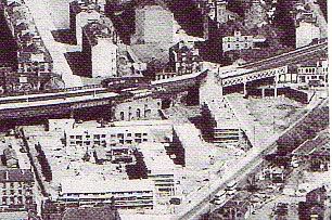
Clearly the bridge we can see has a flat top edge. Is that an arched top edge just to the left poking up above the flat one? Come to think of it, there is a big bit of blank wall immediately next to where the bridge is now that isn't in keeping with the rest of the shop buildings.
Clearly the bridge we can see has a flat top edge. Is that an arched top edge just to the left poking up above the flat one? Come to think of it, there is a big bit of blank wall immediately next to where the bridge is now that isn't in keeping with the rest of the shop buildings.
I see dead buildings...
-
JamesMc - Second Stripe
- Posts: 286
- Joined: Sun Jul 11, 2004 3:41 pm
- Location: Glasgow
![]() by stinkpad » Sat Apr 23, 2005 9:11 pm
by stinkpad » Sat Apr 23, 2005 9:11 pm
JamesMc wrote:Clearly the bridge we can see has a flat top edge. Is that an arched top edge just to the left poking up above the flat one? Come to think of it, there is a big bit of blank wall immediately next to where the bridge is now that isn't in keeping with the rest of the shop buildings.
Yup, used to pass it all the time on the bus, the gap where the bridge used to join has been bricked up.
-
stinkpad - Third Stripe
- Posts: 403
- Joined: Mon Jan 19, 2004 1:42 pm
- Location: Cathcart
![]() by Targer » Sun Apr 24, 2005 2:52 pm
by Targer » Sun Apr 24, 2005 2:52 pm
From the photo. by JamesMc I see they (GCC) started to demolish the area even in 1962? I thought the demolition program started late say 1965. I knew this area well and its to bad its changed...for ever.
- Targer
- Second Stripe
- Posts: 181
- Joined: Fri Jan 10, 2003 9:20 pm
- Location: Ontario,Canada
![]() by escotregen » Sun Apr 24, 2005 6:31 pm
by escotregen » Sun Apr 24, 2005 6:31 pm
Schiehallion, as always for me the value of these great everyday photographs is the little incindentals. On the middle extreme right there is a Morris Minor, and behind it is that a Hillman Imp? If so it would have been relatively new and trendy at that time.
The Belisha beacon that appears to stick right out the top of the Morris Minor seems very tall? I thought they were just for Zebra crossings and that those ones were not as tall - in the photograph it doesn't seem to be the location for a Zebra.
Moving over to the extreme left hand side, see the guy at the lampost and further up outside the shop? Just guys hingin' aboot in a nonedescript street - nowadays New Labour would have an ASBO out on you and have you evicted from the neighbourhood for doing such a thing.
Still on the left hand side; behind the wee van I think that is a cart (as in horse and cart) albeit a fancy one with 'rubber' wheels - still a common sight in mid 60s Glasgows.
Another, for me, surprising detail is in the far horizon beyond the pillared bridge. There seems to be the structure of the awful brutalist multi storey block that is still there today. I'm surprised that (assuming it is the multi) that it was there at that time... possibly still being built?
Anyway I better stop here or else Cumbo and Fossil will be joking again at my expense about my long postings
- escotregen
- Third Stripe
- Posts: 1073
- Joined: Tue Jan 13, 2004 3:35 pm
- Location: glasgow


![]() by james73 » Sun Apr 24, 2005 11:23 pm
by james73 » Sun Apr 24, 2005 11:23 pm
JamesMc wrote:Yes, it is indeed the same scene. I can see where the confusion came from though, and thanks to stinkpad and lordsleek for clearing some of that up. As Lordsleek said, Hospital st at this point has has been widened and re-angled.Where the tenements on the left stood has been curtailed.
The bridge. I am a wee bit unclear on this one myself. It does look like a different bridge. The one there in the present does have pillar support on the far side, rusted so a bit hard to make out. The old bridge clearly has support on the nearest side.
Now stinkpad, do you think there were two separate bridges? Or has the bridge just been modified?
There were two seperate bridges as that section of the viaduct had four tracks
on it. After the closure of St Enoch it was reduced to two tracks, so a few
bridges were either removed or modified, and sections of the brick
viaduct demolished.
James H
- james73
- Third Stripe
- Posts: 2035
- Joined: Wed Dec 17, 2003 4:08 pm
- Location: urbanglasgow.co.uk - come & join us.....
Return to Hidden Glasgow Projects
Who is online
Users browsing this forum: Google [Bot] and 38 guests