Page 2 of 28

PostPosted: Thu Oct 30, 2003 3:38 pm
by caine
where was the underground room jim? my mates girlfriends sister works for the land services dept for the council, i could get her to check if there were any old buildings down there for you if you want. she's done it for us before. useful contact :wink:

Underground room(s)

PostPosted: Thu Oct 30, 2003 8:18 pm
by jim
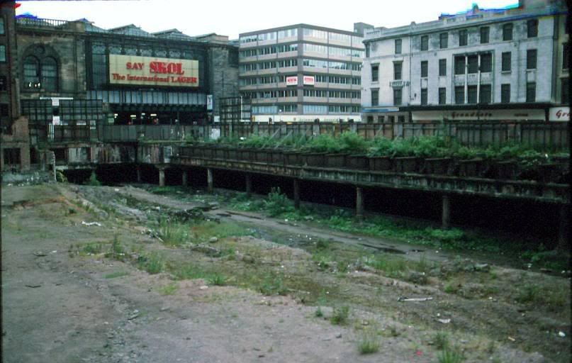
Its really just a hole in the ground next to the back entrance to the big carpark at the top of Duke St, just near the old facade. As you start up this road look to your left, after a few yards you will notice the hole. Seems to extend quite far underground. You can just glimpse a doorway leading on into the darkness . . .
I'm assuming these are old railway sidings and therefore it has something to do with that? Any light you can shed on this would be great.

PostPosted: Fri Oct 31, 2003 9:32 am
by caine
i'll see what i can do :wink:

Fraggle rock

PostPosted: Fri Oct 31, 2003 1:36 pm
by cataclyzm
Hi,

Well; it's a tenuous link I know, but I definitely remember fraggle rocks, inhabitants living underground in subterranean cave like things.

Eek...it was only a joke.

Robert.

PostPosted: Fri Oct 31, 2003 3:12 pm
by caine
::): fair enough mate! i thought it was something else some one had found tucked away some where else!

but yeah, the fragles had a cool wee cave place going on eh?! :D

PostPosted: Thu Nov 27, 2003 5:00 pm
by Mudoken
in the ilegal tunnel-rave's are there any toilets?

and alchohl?

PostPosted: Thu Nov 27, 2003 5:24 pm
by Some Guy
Mudoken wrote:in the ilegal tunnel-rave's are there any toilets?

and alchohl?


The toilet is generally the nearby field and it's a case of bring your own booze!

It's a risky enough business without being stung for selling booze without a licence!!!!!

Tunnel under Maryhill shopping centre

PostPosted: Wed Jan 07, 2004 3:27 pm
by Seamey
Someone mentioned the railway tunnel heading north of Maryhill Road under Ruchill. However there is also a tunnel under the shopping centre itself. When the centre was being built (early 80s) there were provisional plans for reopening the Maryhill railway line and there was to be a railway station across the road - where the Bingo carpark is.

You certainly used to be able to see the tunnel from the bottom of the carpark at Garrioch Road.

Seamey

Re: Tunnel under Maryhill shopping centre

PostPosted: Wed Jan 07, 2004 5:43 pm
by james73
Seamey wrote:Someone mentioned the railway tunnel heading north of Maryhill Road under Ruchill. However there is also a tunnel under the shopping centre itself. When the centre was being built (early 80s) there were provisional plans for reopening the Maryhill railway line and there was to be a railway station across the road - where the Bingo carpark is.


Just at the point it used to cross the River Kelvin, that line came from
Kelvinbridge/Botanic Gardens/Kirklee and was met with another line
which began at what was Partick West station. This line travelled north
over Dumbarton Road and entered a tunnel (stil there) and re-appeared
near Crow Road (I think there was a station at Crow Road too). It then
passed under the current line at the site of the present Hyndland station,
headed north under Great Western Road, into another tunnel under
Kelvinside, before emerging near the Kelvin.

The two seperate bridges over the river are still in situ, and had formed a
junction prior to entering Maryhill station. You're right about the shopping
centre - they built a tunnel (only single track I think) under it in case it
was to be re-opened as either rail or a tram line.

Someone in another thread mentioned the section of this line that passed
through Maryhill and under the Canal. I'm not sure the current state of
play with those tunnels, but I suspect they may be blocked off. The line
had carried on to Possil, before looping around the north of the city
through Springburn and Barmulloch before heading south past the
Provan gas works, past the Forge & Celtic Park, before heading down
to Rutherglen junction. There's little of this section left as most of it was
on high embankments, bridges and viaducts - virtually all gone now.


James H

PostPosted: Sat Jan 10, 2004 12:16 am
by applemaca
Hi,
Heard a story about more platforms at central L/Level.

True or False? 8O

PostPosted: Sat Jan 10, 2004 2:17 am
by james73
applemaca wrote:Hi,
Heard a story about more platforms at central L/Level.

True or False? 8O


True. There's another 'island' platform to the north of the current low level
platform. When you're entering the station on a train you can see something
at the side of the station. Originally, there was 4 tracks in the low level
station prior to it's closure in 1964. They *could* reopen the other platform
and use it to terminate services from Lanarkshire, although this seems
unlikely as they have a turnback siding at the SECC station.


James H

PostPosted: Sat Jan 10, 2004 7:52 pm
by Pgcc93
applemaca wrote:Hi,
Heard a story about more platforms at central L/Level.

True or False? 8O


As James 73 says there is indeed a disused island platform on the North side of the East bound low level. But as for reopening it would be doubtfull as part of it is now the basement for the Westergate building situated at the corner of Argyle Street and Hope Street and it contains plant and services equipment at present.
I checked the old platform out a few years back in an, Ahem! official works capacity. I can confirm that only part of it still exists at the eastern end and has the recognisable support pillars as in the 'In Use' platforms. The track bed was not of regular ballast but covered in a red blaise material, perhaps this came about during the building of the Westergate site.
IIRC there is a pic on the net of the vacant site circa 1977 showing the vacant land at Hope Street which also shows the exposed low level area prior to reopening. I'll post the Url: if I can find it.

PGCC

Tunnels

PostPosted: Sat Jan 10, 2004 8:06 pm
by Pgcc93
Here's a pic of the afore mentioned reply re: the Disused Low Level Platforms. Thanks to the folks at Eastbank MRC. Hope this helps.

The platform in question looks partialy demolished in the picture, but you'll get the idea.

Image

Re: Tunnels

PostPosted: Sat Jan 10, 2004 8:51 pm
by james73
So, the support pillars in that picture are the actual 'middle-of-the-platform'
supports on the disused platform? I have that picture (and have had it
for a while) and had assumed that when they built that Westergate building
in the early 1980's, they had left the space beneath it, as was the case
with the original single story victorian buildings which stood there previously?


James H

Tunnels

PostPosted: Sat Jan 10, 2004 9:39 pm
by Pgcc93
Hi James,
I may have caused a little confusion regarding the old platform.

The platform supports that are visible in the pic are the ones that are on
the existing L/L platforms. The ones I have seen on the 'Old Platform' ln situ are on the far left of the picture and situated inside the eastbound tunnel,hence not shown The old supports would have continued had they not been removed prior to the picture being taken.

If you can get a hold of O S Nock's The Caledonian Railway there is a cross section drawing of the Platforms on the Low Level on P.115 Try your local library or the Mitchell. Although not fully illustrated it might give a rough idea as to it's layout.

PGCC