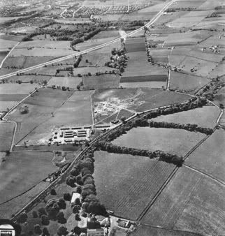
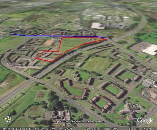
Looks as though it was situated just to the west of Wellhouse Rd (blue line), the demolition patches (red trapezoid) on the google earth image:
To post in the forums you will need to first register. All new members are welcomed, with one caveat: You must behave and be nice AND SEARCH BEFORE POSTING!
Moderators: John, Sharon, Fossil, Lucky Poet, crusty_bint, Jazza, dazza
![]() by crusty_bint » Mon Jan 16, 2006 9:23 pm
by crusty_bint » Mon Jan 16, 2006 9:23 pm

![]() by escotregen » Mon Jan 16, 2006 10:16 pm
by escotregen » Mon Jan 16, 2006 10:16 pm

![]() by crusty_bint » Mon Jan 16, 2006 10:26 pm
by crusty_bint » Mon Jan 16, 2006 10:26 pm
![]() by Socceroo » Mon Jan 16, 2006 10:29 pm
by Socceroo » Mon Jan 16, 2006 10:29 pm

![]() by crusty_bint » Mon Jan 16, 2006 10:34 pm
by crusty_bint » Mon Jan 16, 2006 10:34 pm
![]() by crusty_bint » Mon Jan 16, 2006 10:37 pm
by crusty_bint » Mon Jan 16, 2006 10:37 pm
![]() by AlanM » Mon Jan 16, 2006 10:40 pm
by AlanM » Mon Jan 16, 2006 10:40 pm
crusty_bint wrote:N6 Khyber Pass - Craigend... which Craigend do you know??? There's a Craigend beside Garthamlock nestled under the water towers, think thats it? I think thats also the highest hill in Glasgow so might have been a good place furr a fun?


![]() by crusty_bint » Mon Jan 16, 2006 10:44 pm
by crusty_bint » Mon Jan 16, 2006 10:44 pm
![]() by AlanM » Mon Jan 16, 2006 10:45 pm
by AlanM » Mon Jan 16, 2006 10:45 pm
![]() by escotregen » Mon Jan 16, 2006 10:58 pm
by escotregen » Mon Jan 16, 2006 10:58 pm
![]() by Apollo » Wed Jan 18, 2006 1:18 am
by Apollo » Wed Jan 18, 2006 1:18 am
My Kitten wrote:What I'm really looking for is a downloadable map that I can highlight the streets. Stumped!

![]() by radar » Thu Jan 19, 2006 1:47 am
by radar » Thu Jan 19, 2006 1:47 am

![]() by motman » Thu Jan 19, 2006 1:54 pm
by motman » Thu Jan 19, 2006 1:54 pm

![]() by Socceroo » Thu Jan 19, 2006 5:04 pm
by Socceroo » Thu Jan 19, 2006 5:04 pm
Return to Hidden Glasgow Projects
Users browsing this forum: No registered users and 20 guests